Class 9: Social science: contemporary India-I: textbook in geography for class IX, 2006
- Chapter 1 - India: Size and Location
Introduction
1. India's Historical Significance
- Ancient civilization.
- Significant contributor to world history.
2. Socio-Economic Progress
- Multifaceted progress over the last five decades.
3. Key Achievements
- Agriculture
- Industry
- Technology
- Overall economic development.
Map
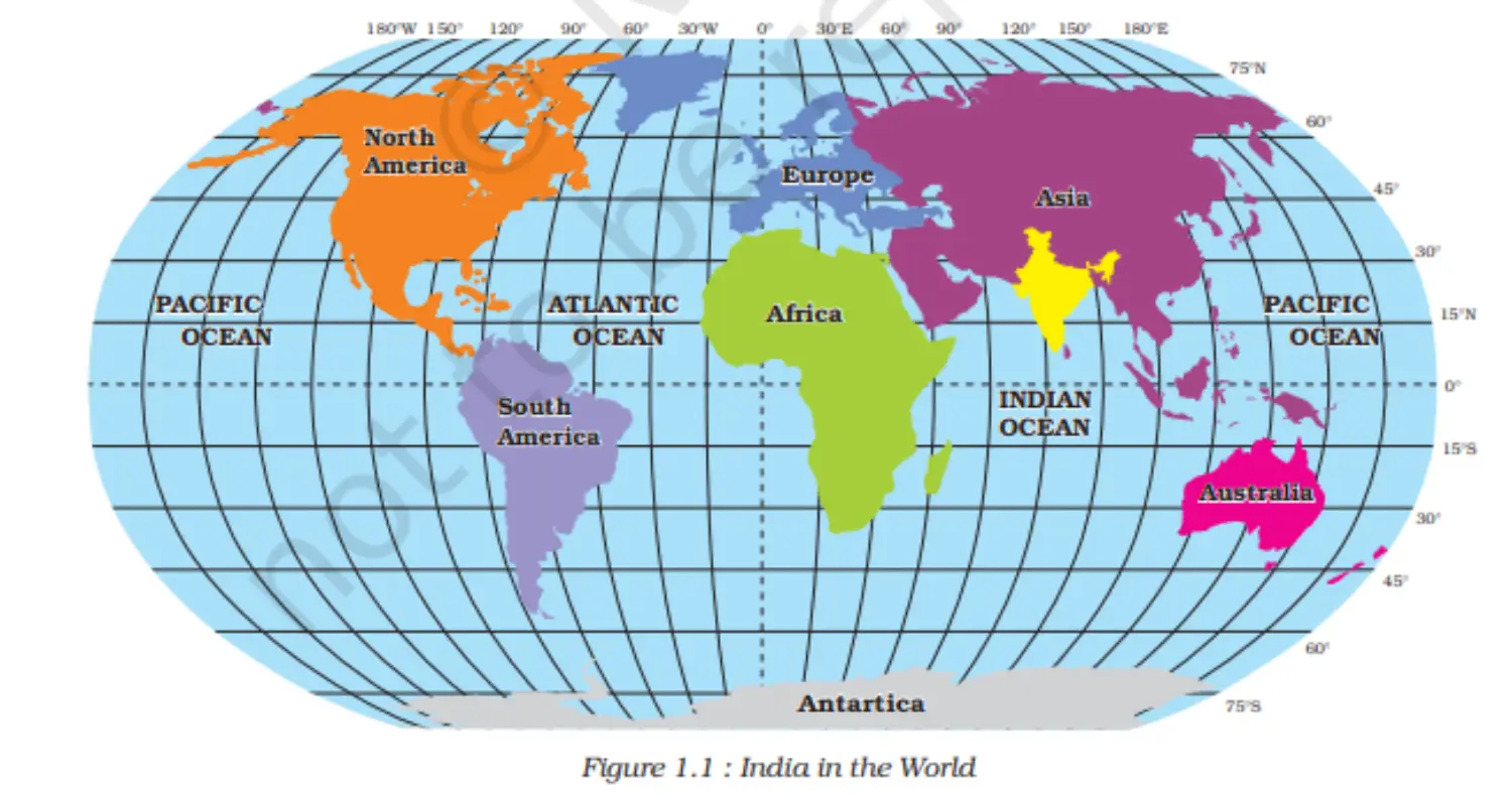
Location
1. Location of India
- Situated entirely in the Northern hemisphere.
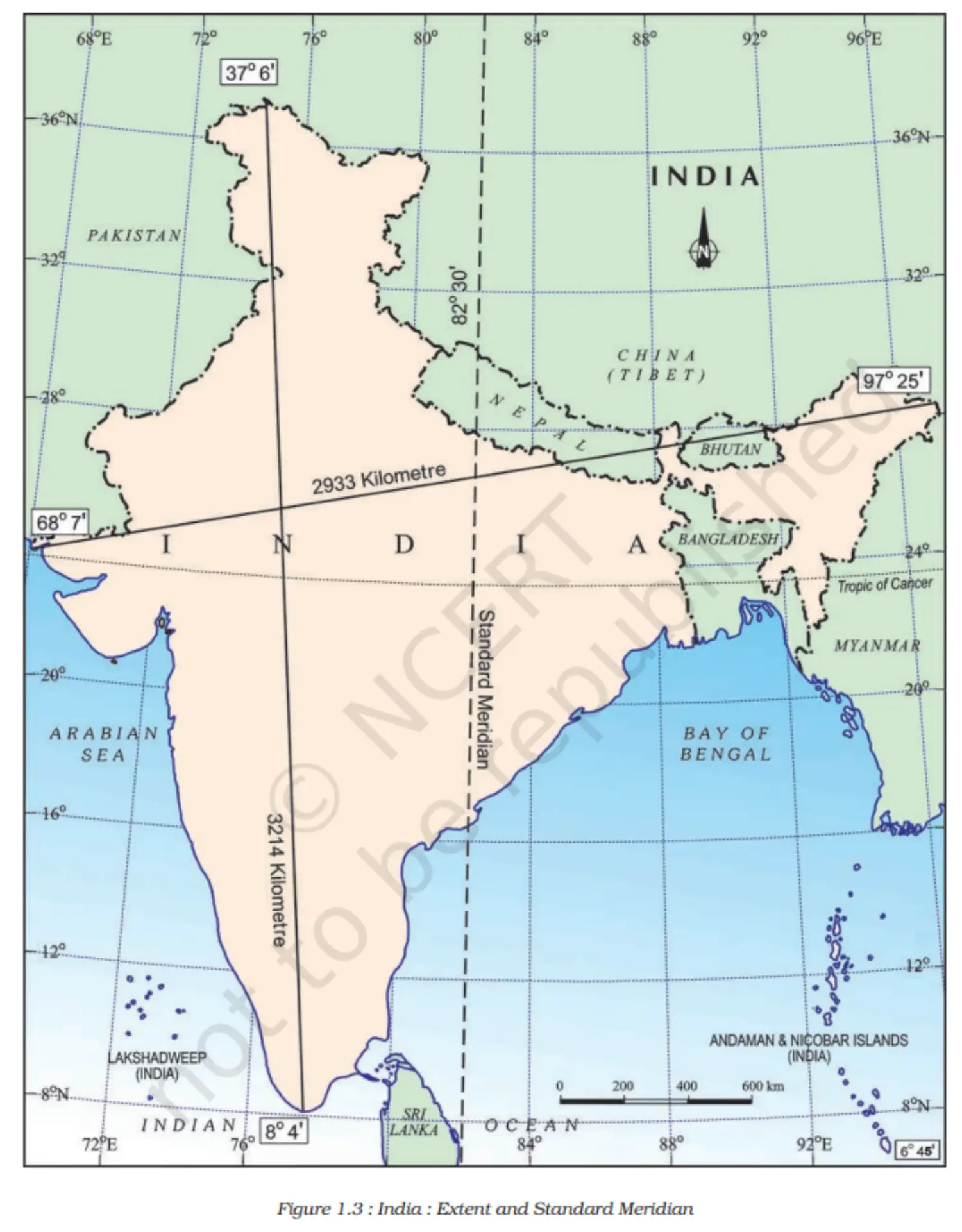
- Mainland latitude: 8°4'N to 37°6'N
- Mainland longitude: 68°7'E to 97°25'E
2. Tropic of Cancer
- Passes through India at 23° 30'N.
- Divides India into approximately two equal parts.
3. Islands of India
- Southeast of mainland: Andaman and Nicobar islands (Bay of Bengal)
- Southwest of mainland: Lakshadweep islands (Arabian Sea)
- (Note: Check atlas for exact extent of these islands.)
Size
1. Size and Global Position of India
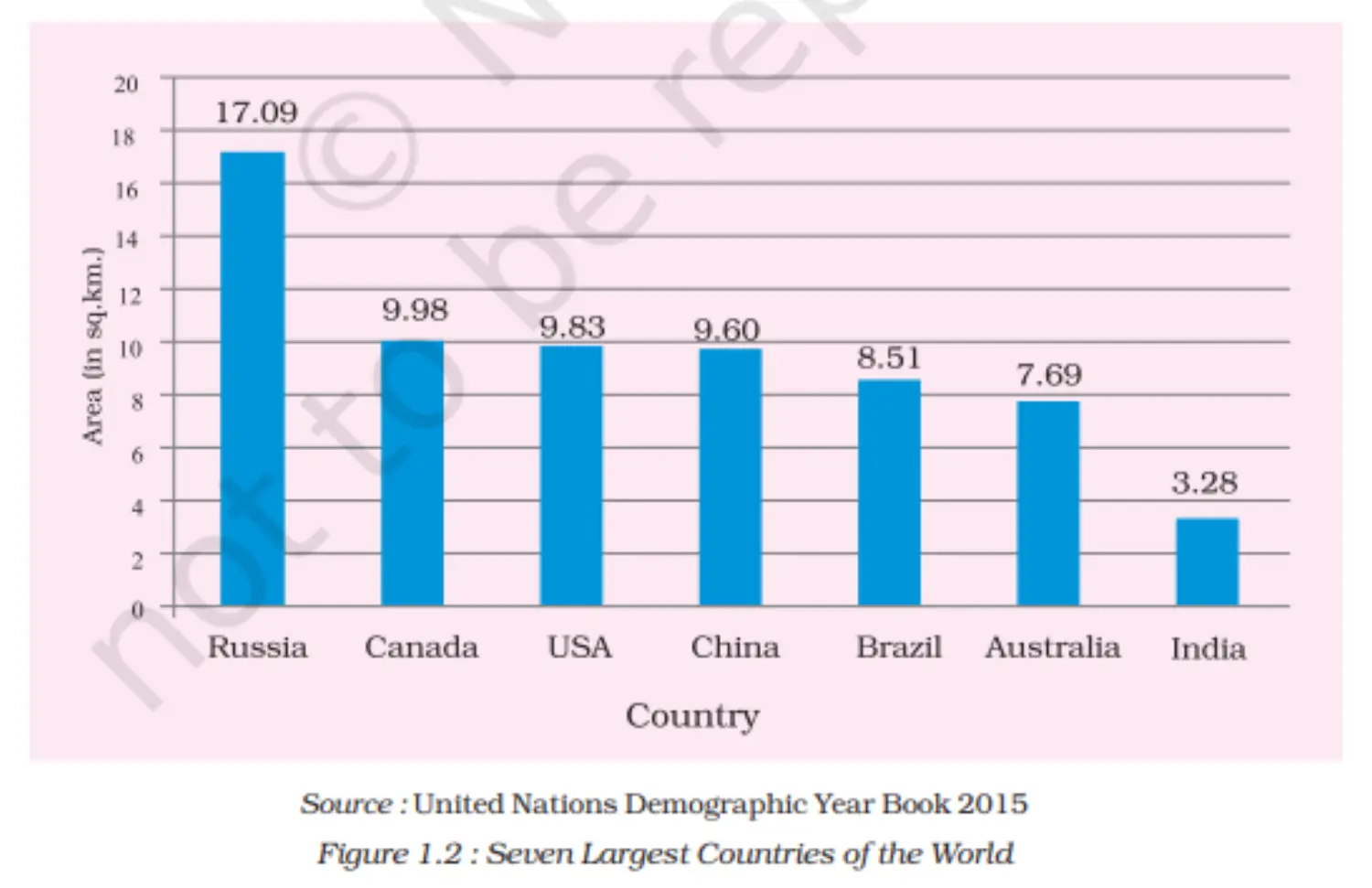
- Area: 3.28 million square km.
- Accounts for 2.4% of the world's geographical area.
- Ranks 7th in terms of size globally.
2. Boundaries and Coastline
- Land boundary: 15,200 km.
- Total coastline (including islands): 7,516.6 km.
3. Geographic Features
- Bordered by young fold mountains in the northwest, north, and northeast.
- Tapers southwards, dividing the Arabian Sea (west) and Bay of Bengal (east).
4. Extent and Time Zone
Latitudinal and longitudinal extent is approximately 30°.
East-west extent appears shorter than north-south extent.
Time difference of two hours from Gujarat to Arunachal Pradesh.
Standard time is based on 82°30'E meridian through Mirzapur, Uttar Pradesh.
Latitudinal extent affects the duration of day and night.
Graph
India and the World
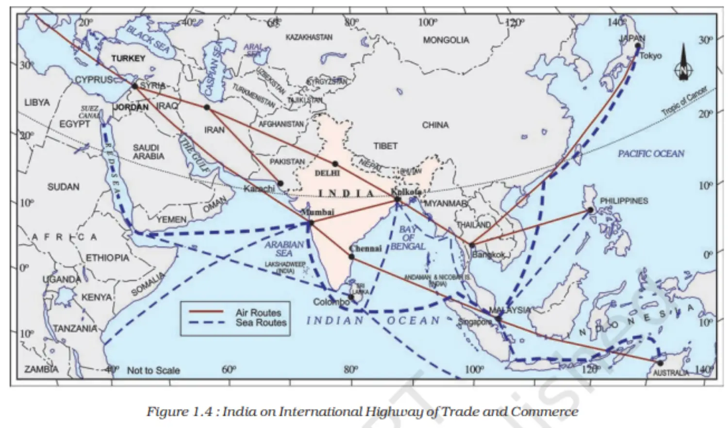
1. India's Strategic Position
- Central location between East and West Asia.
- The southward extension of the Asian continent.
2. Importance in Maritime Routes
- Trans-Indian Ocean routes connect Europe and East Asia, giving India a strategic advantage.
- Deccan Peninsula's protrusion facilitates connections with West Asia, Africa, Europe, Southeast, and East Asia.
- India has the longest coastline on the Indian Ocean, leading to the ocean's naming after the country.
3. Historical Contacts
- Land route interactions are older than maritime contacts.
- Northern mountain passes served as ancient travel routes.
- These routes enabled exchange of ideas and commodities.
4. Cultural and Commodity Exchange
Exported: Upanishads, Ramayana, Panchtantra stories, Indian numerals, decimal system, spices, and muslin.
Imported: Greek sculpture influence, dome, and minaret architectural styles from West Asia.
Map 1
Map 2
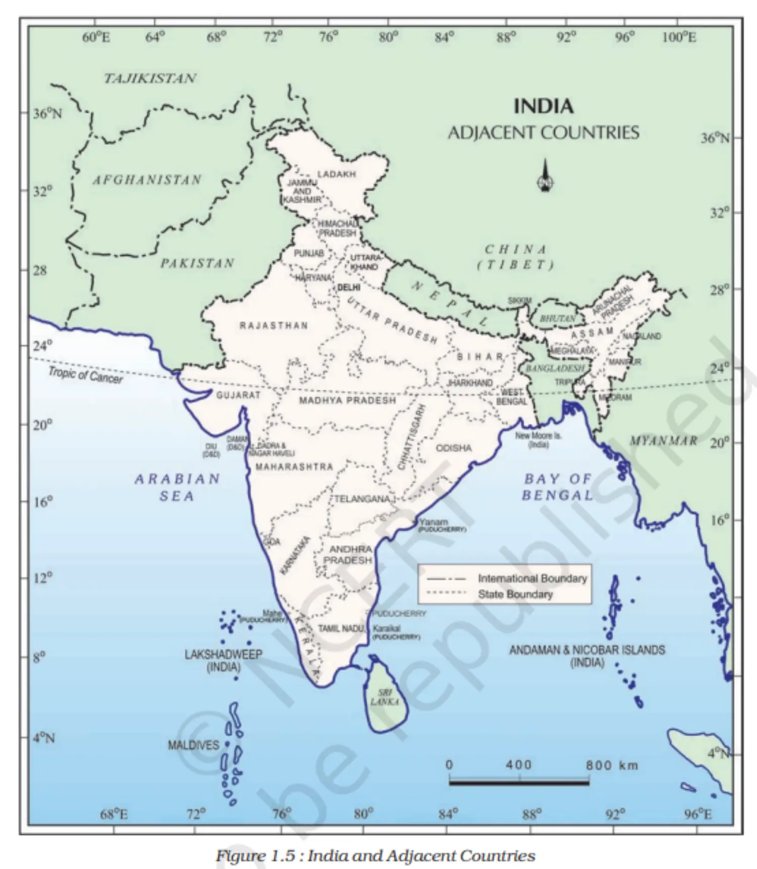
India’s Neighbors
1. India's Geographical Position
- Strategic position in South Asia.
- Comprises 28 states and eight Union Territories.
2. Land Neighbours
- Northwest: Pakistan and Afghanistan.
- North: China (Tibet), Nepal, and Bhutan.
- East: Myanmar and Bangladesh.
3. Maritime Neighbours
- Sri Lanka: Separated by Palk Strait and the Gulf of Mannar.
- Maldives: South of Lakshadweep Islands.
4. Historical Links
India has significant geographical and historical ties with neighboring countries.
Stands distinct in the Asian continent.
Map
Additional Concepts
1. Suez Canal and India
- Opened in 1869.
- Reduced India's distance from Europe by 7,000 km.
2. Pre-1947 Indian States Classification
- Provinces:
- Directly ruled by British officials appointed by the Viceroy.
- Princely States:
- Ruled by local, hereditary rulers.
- Acknowledged British sovereignty in exchange for local autonomy.
3. School Bhuvan Portal
- Map-based learning platform.
- Raises awareness about India's natural resources, environment, and sustainable development.
- Initiative of Bhuvan — NRSC/ISRO.
- Chapter 2 - Physical Features of India
Introduction
- Landforms in India:
- Variety: India boasts a diverse range of landforms including mountains, plains, deserts, plateaus, and islands.
- Peninsular Plateau:
- Age: One of the oldest landmasses on Earth.
- Stability: Considered one of the most stable land blocks.
- Composition: Made up of igneous and metamorphic rocks; features gently rising hills and broad valleys.
- Himalayas:
- Age: Among the youngest landforms.
- Stability: Geologically unstable zone.
- Features: Youthful topography with high peaks, deep valleys, and rapid rivers.
- Northern Plains:
- Formation: Created from alluvial deposits.
- Landforms in India:
Major Physiographic Divisions
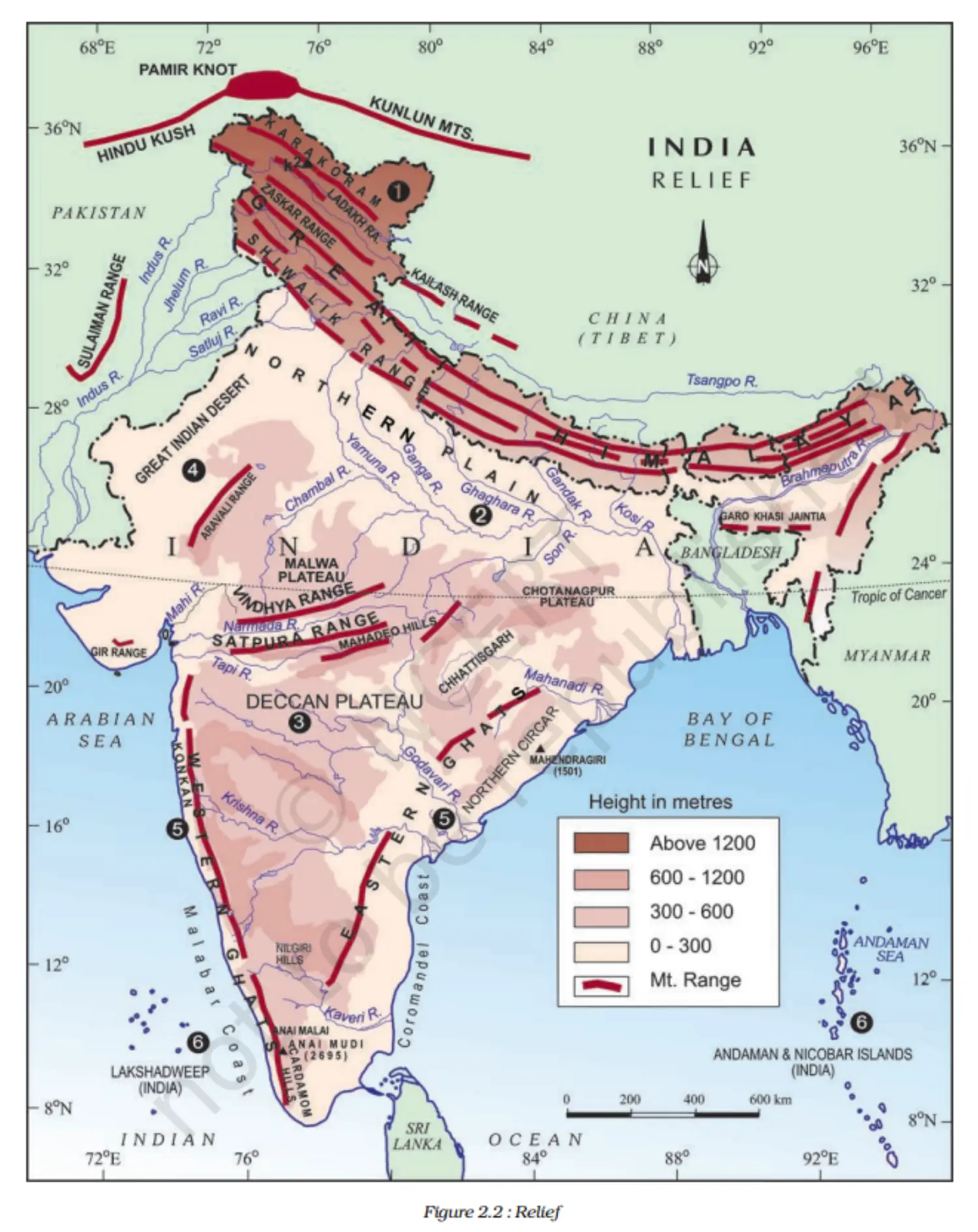
1. Major Physiographic Divisions of India:
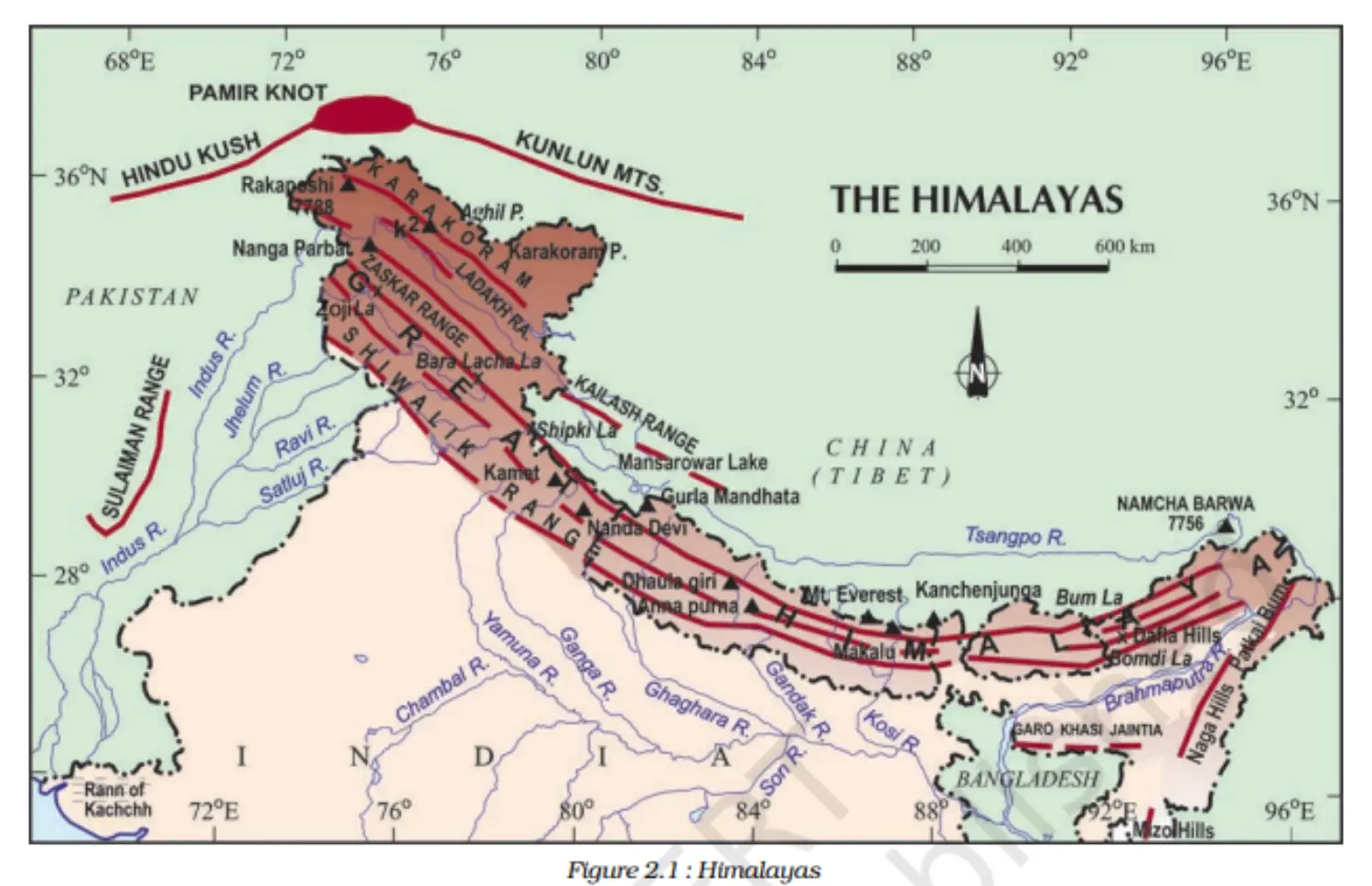
(1) The Himalayan Mountains: Young, fold mountains that run from the Indus to the Brahmaputra in a west-east direction.
- Comprises three parallel ranges with various valleys in between.
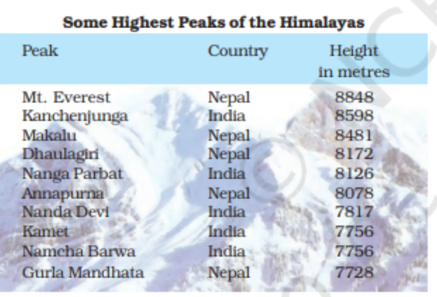
- Great or Inner Himalayas (Himadri): Most continuous with an average height of 6,000 metres.
- Lesser Himalaya (Himachal): Rugged mountain system with an altitude between 3,700 and 4,500 metres.
- Shiwaliks: Lowest range with an altitude between 900 and 1100 metres.
(2) The Northern Plains: Formed by the interplay of the Indus, Ganga, and Brahmaputra rivers. Fertile and agriculturally productive.
(3) The Peninsular Plateau: Ancient landmass comprising the Central Highlands and the Deccan Plateau.
- Central Highlands: Lies north of the Narmada River with the Vindhyan range as a notable feature.
- Deccan Plateau: Triangular landmass south of the Narmada River, flanked by the Western and Eastern Ghats.
(4) The Indian Desert: Sandy Plain in the west, characterized by sand dunes and low rainfall.
(5) The Coastal Plains: Narrow strips along the Arabian Sea and Bay of Bengal.
- Western Coastal Plains: Includes Konkan, Kannad, and Malabar coasts.
- Eastern Coastal Plains: Features large deltas formed by rivers like Mahanadi, Godavari, Krishna, and Kaveri.
(6) The Islands:
- Lakshadweep Islands: Near Kerala, formed of coral islands.
- Andaman and Nicobar Islands: Elongated chain in the Bay of Bengal, significant for biodiversity.
Map 1
Table
Map 2
Additional Concepts
1. Terminology and Geographic Features
- (1) Doab:
- Derived from: ‘do’ (two) + ‘ab’ (water)
- Significance: Land between two rivers.
- (2) Punjab:
- Derived from: ‘Punj’ (five) + ‘ab’ (water)
- Significance: Region of five rivers.
- (3) Majuli:
- Location: Brahmaputra River.
- Notable for: Being the largest inhabited riverine island globally.
- (4) Chilika Lake:
- Location: Odisha, south of the Mahanadi delta.
- Notable for: Being India's largest saltwater lake.
- (5) Barren Island:
- Location: Andaman and Nicobar Islands.
- Notable for: Housing India's only active volcano.
- (1) Doab:
- Chapter 3 - Drainage
Introduction
1. Drainage Concepts
- (1) Drainage: Describes the river system of an area.
- (2) Formation: Small streams converge to form the main river which drains into larger water bodies (e.g., lake, sea, ocean).
- (3) Drainage Basin: Area drained by a single river system.
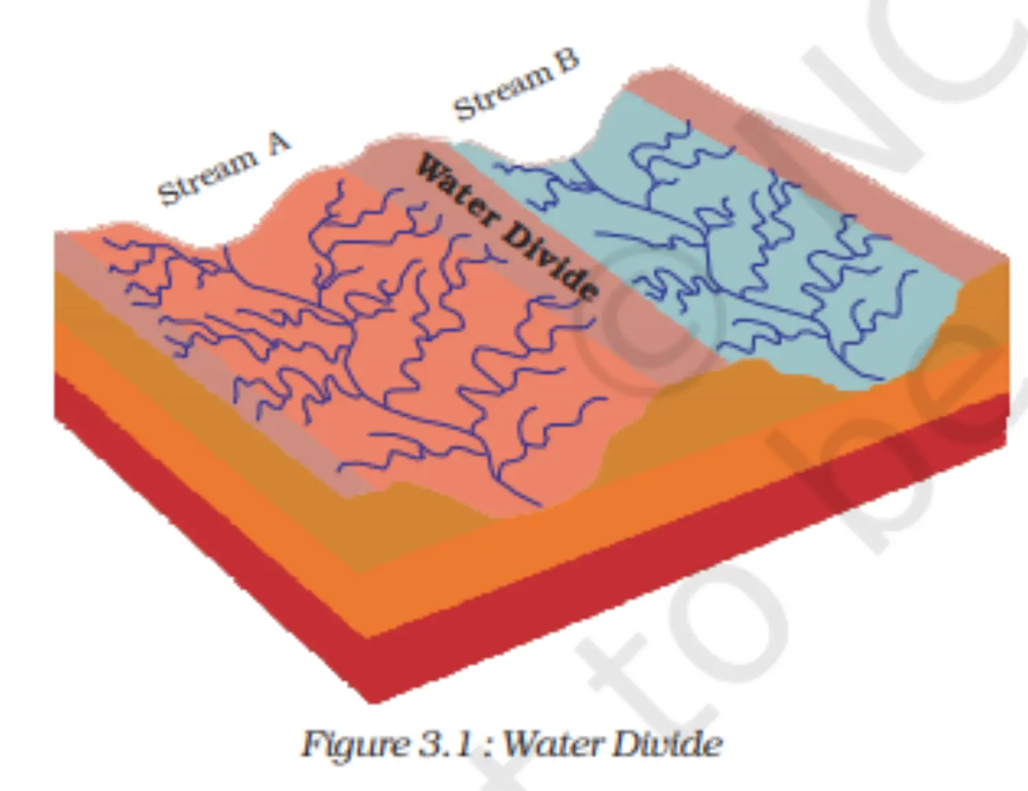
- (4) Water Divide: Elevated areas (like mountains or uplands) that separate two drainage basins.
Drainage systems in India
- Controlled by India's relief features.
- (1) Himalayan Rivers:
- Perennial (water throughout the year).
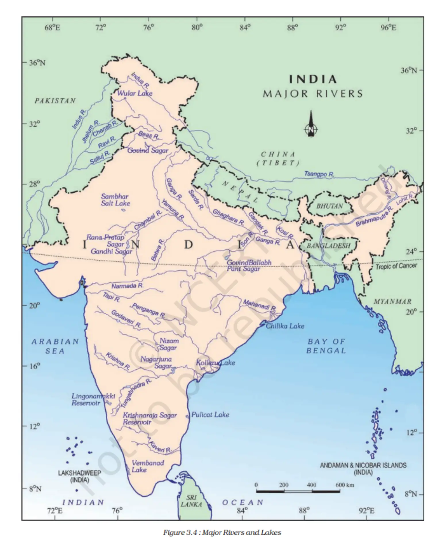
- Major rivers: Indus, Ganga, Brahmaputra.
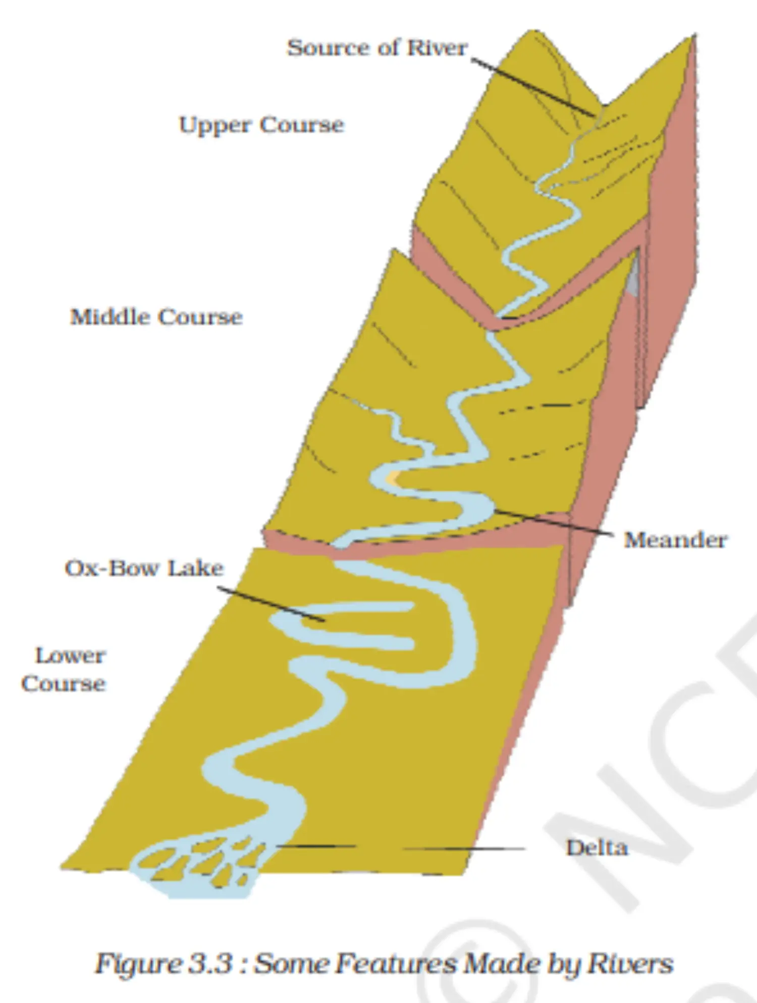
- Characteristics: Long courses, erosional activity, meanders, oxbow lakes, deltas.
- (2) Peninsular Rivers:
- Seasonal (dependent on rainfall).
- Major rivers: Mahanadi, Godavari, Krishna, Kaveri.
- Characteristics: Shorter courses, deltas (for east-flowing rivers), and estuaries (for west-flowing rivers).
2. Indus River System
- Origin: Tibet (near Lake Mansarovar).
- Enters India: Ladakh.
- Tributaries: Zaskar, Nubra, Shyok, Hunza, Satluj, Beas, Ravi, Chenab, Jhelum.
- Length: 2900 km.
3. Ganga River System
- Headwaters: Bhagirathi (Gangotri Glacier).
- Major Tributaries: Yamuna, Ghaghara, Gandak, Kosi, Chambal, Betwa, Son.
- Features: Meanders, oxbow lakes, delta (Sundarban Delta).
4. Brahmaputra River System
- Origin: Tibet (east of Mansarowar lake).
- Enters India: Arunachal Pradesh.
- Characteristics: Braided channels, riverine islands, frequent flooding.
5. Peninsular Rivers
West-flowing: Narmada, Tapi, Sabarmati, Mahi, Bharathpuzha, Periyar.
East-flowing: Godavari, Mahanadi, Krishna, Kaveri.
Image
Image
Map
Lakes
1. Lakes in India
- (1) Introduction:
- Famous lakes: Dal Lake in Kashmir, lakes in tourist spots like Nainital.
- Lakes enhance tourist attractions.
- (2) Characteristics:
- Vary in size and nature.
- Some are permanent, while others are seasonal (e.g., in semi-arid regions).
- (3) Formation:
- Glacial activity: Most freshwater lakes in the Himalayan region.
- Wind, river action, human activities.
- Oxbow lakes: Formed by meandering rivers.
- Lagoons: Formed by spits and bars (e.g., Chilika Lake, Pulicat Lake).
- Tectonic activity: e.g., Wular Lake (largest freshwater lake in India).
- Human-made: Due to the damming of rivers, e.g., Guru Gobind Sagar from Bhakra Nangal Project.
- (4) Importance:
- Flood control.
- Maintaining even river flow.
- Hydel power generation.
- Climate moderation.
- Aquatic ecosystem support.
- Enhancing natural beauty and tourism.
- (1) Introduction:
Role of Rivers in the Economy
- (1) Historical Significance:
- Rivers have always played a pivotal role in human history.
- Riverbanks have been prime locations for ancient settlements, now evolved into major cities.
- (2) Essential Resource:
- Rivers provide water, a fundamental natural resource for numerous human activities.
- (3) Economic Importance:
- Irrigation: Vital for agriculture, especially in regions with inconsistent rainfall.
- Navigation: Rivers serve as natural waterways for transportation.
- Hydro-power Generation: Rivers are sources for generating renewable energy.
- Settlements: Many major cities globally have evolved from settlements near rivers.
- (4) Special Mention:
- In countries like India, rivers are especially significant due to the agricultural prominence in the economy.
- (1) Historical Significance:
River Pollution
1. River Pollution Causes
- (1) Increased Demand: Growing needs from domestic, municipal, industrial, and agricultural sectors.
- (2) Draining Rivers: Excessive water withdrawal reduces river volumes.
- (3) Sewage & Effluents: Untreated sewage and industrial wastes are discharged into rivers, affecting water quality.
- (4) Reduced Self-cleansing: Pollution hampers a river's natural ability to cleanse itself. For instance, the Ganga could naturally dilute pollutants within 20 km of large cities, but urbanization affects this ability.
2. Consequences & Remedies
- (1) Elevated Pollution Levels: Due to unchecked urbanization and industrialization.
- (2) Action Plans: Various initiatives launched to combat river pollution.
- (3) Health Impact: Polluted river water poses health risks.
- (4) Importance of Fresh Water: Reflect on the implications of a life without fresh water.
Additional Concepts
1. Global & National River Facts
- (1) Amazon River: Boasts the world's largest drainage basin.
- (2) Indus Water Treaty (1960):
- India is entitled to only 20% of the Indus River system's water.
- Used for irrigation in Punjab, Haryana, and parts of Rajasthan.
- (3) Namami Gange Programme:
- Launched in June 2014 by the Union Government.
- Aims: Pollution abatement and Ganga river rejuvenation.
- (4) Sundarban Delta:
- Named after the Sundari tree.
- World's largest and fastest-growing delta.
- Habitat for the Royal Bengal tiger.
- (5) River Names:
- Brahmaputra: Tsang Po in Tibet, Jamuna in Bangladesh.
- (6) Narmada Conservation:
- An initiative by the Madhya Pradesh government: Namami Devi Narmade.
- (7) Kaveri River:
- Features India's second-largest waterfall: Shivasamudram Falls.
- Hydroelectric power from this benefits several regions including Mysuru and Bengaluru.
- (8) Global Water Statistics:
- Earth's surface is 71% water.
- 97% of it is salt water.
- Of the 3% freshwater, 75% is ice.
- (9) Lakes:
- Large lakes are termed seas (e.g., Caspian, Dead, and Aral seas).
2. National River Conservation Plan (NRCP)
- (1) Initiation:
- Started with the Ganga Action Plan (GAP) in 1985.
- (2) Expansion:
- By 1995, it expanded to include other rivers under NRCP.
- (3) Main Objective:
- Enhance river water quality through pollution abatement.
- Chapter 4 - Climate
Introduction
1. Introduction to Climate
- (1) Climate vs. Weather: Climate is the average weather condition over a long period (>30 years). Weather is the atmospheric state at a particular time.
- (2) Elements: Temperature, atmospheric pressure, wind, humidity, and precipitation.
- (3) Seasons: Derived from general monthly atmospheric conditions. E.g., winter, summer, rainy.
2. Indian Climate Characteristics
- (1) Monsoon Type: Predominant in South and Southeast Asia.
- (2) Regional Variations: Despite a unified pattern, there are discernible differences across regions.
3. Temperature in India
- (1) Summer: Up to 50°C in Rajasthan; around 20°C in Pahalgam, J&K.
- (2) Winter: As low as -45°C in Drass, J&K; around 22°C in Thiruvananthapuram.
4. Precipitation in India
- (1) Forms: Snowfall in the Himalayas, rainfall in the rest of the country.
- (2) Amount: Over 400 cm in Meghalaya; less than 10 cm in Ladakh and western Rajasthan.
- (3) Seasons: Majority from June to September; Tamil Nadu gets rain in October and November.
5. Coastal vs. Interior Regions
- Coastal areas have less temperature contrast. Interior regions exhibit more seasonal contrasts.
- Rainfall decreases from east to west in Northern Plains.
- Variations influence lifestyle, including food, clothing, and housing.
Climatic Controls
1. Overview
- Climatic Controls: Factors that determine the climate of any location.
2. Six Major Climatic Controls
- (1) Latitude:
- Due to Earth's curvature, solar energy varies with latitude.
- Temperature decreases from the equator to the poles.
- (2) Altitude:
- The atmosphere thins with height; temperature drops.
- Hills and high-altitude areas are cooler.
- (3) Pressure and Wind System:
- Influenced by latitude and altitude.
- Determines temperature and rainfall patterns.
- (4) Distance from the Sea (Continentality):
- Proximity to sea moderates climate.
- Areas far from the sea have extreme temperatures.
- (5) Ocean Currents:
- Warm or cold currents can influence coastal climates.
- Onshore winds can intensify these effects.
- (6) Relief Features (Topography):
- Mountains can block or redirect prevailing winds.
- Rain shadow effect on leeward sides of mountains.
Factors Affecting India’s Climate
1. Overview
- Factors Affecting India’s Climate: Elements that determine the climatic patterns of India.
2. Major Factors
- (1) Latitude:
- The Tropic of Cancer divides India.
- South of it: Tropical region.
- North of it: Sub-tropical region.
- Result: Mix of tropical & subtropical climates.
- (2) Altitude:
- Northern mountains average about 6,000 meters.
- Coastal regions at about 30 meters elevation.
- Himalayas' Role: Block cold Central Asian winds; give India milder winters.
- (3) Pressure and Winds:
- Governed by:
- a. Surface pressure and winds.
- b. Upper air circulation.
- c. Cyclonic disturbances.
- India: Region of northeasterly winds.
- Winter: High-pressure north of the Himalayas, cold dry winds flow south.
- Summer: Low pressure in interior Asia & northwest India.
- Southwest Monsoon: Winds reverse, come from the sea, and bring widespread rainfall.
- Governed by:
The Seasons
1. Overview
- India experiences distinct seasonal patterns due to its monsoon climate. The coastal areas show less variation, while the interiors show prominent changes.
2. Seasons in India
(1) Cold Weather Season (Winter)
- Time: Mid-November to February.
- North India experiences the coldest months in December & January.
- Temperature gradient: Decreases from south to north.
- Predominant winds: Northeast trade winds. Dry for most parts but brings rainfall to the Tamil Nadu coast.
- Northern plains receive winter rains, important for 'rabi' crops.
(2) Hot Weather Season (Summer)
- Time: March to May.
- Due to the northward movement of the sun, heat increases.
- High temperatures throughout, especially in northwestern parts.
- Phenomena: 'Loo' winds, dust storms, and localized thunderstorms.
(3) Advancing Monsoon (Rainy Season)
- Starts: Early June.
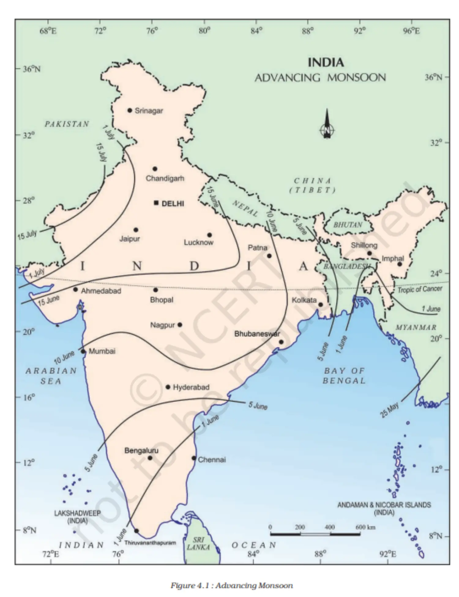
- Characterized by the southwest monsoon winds bringing heavy rainfall.
- Notable features: Monsoon breaks, and fluctuations in rainfall. Heavy rains can lead to floods.
- Variability leads to disruptions for farmers.
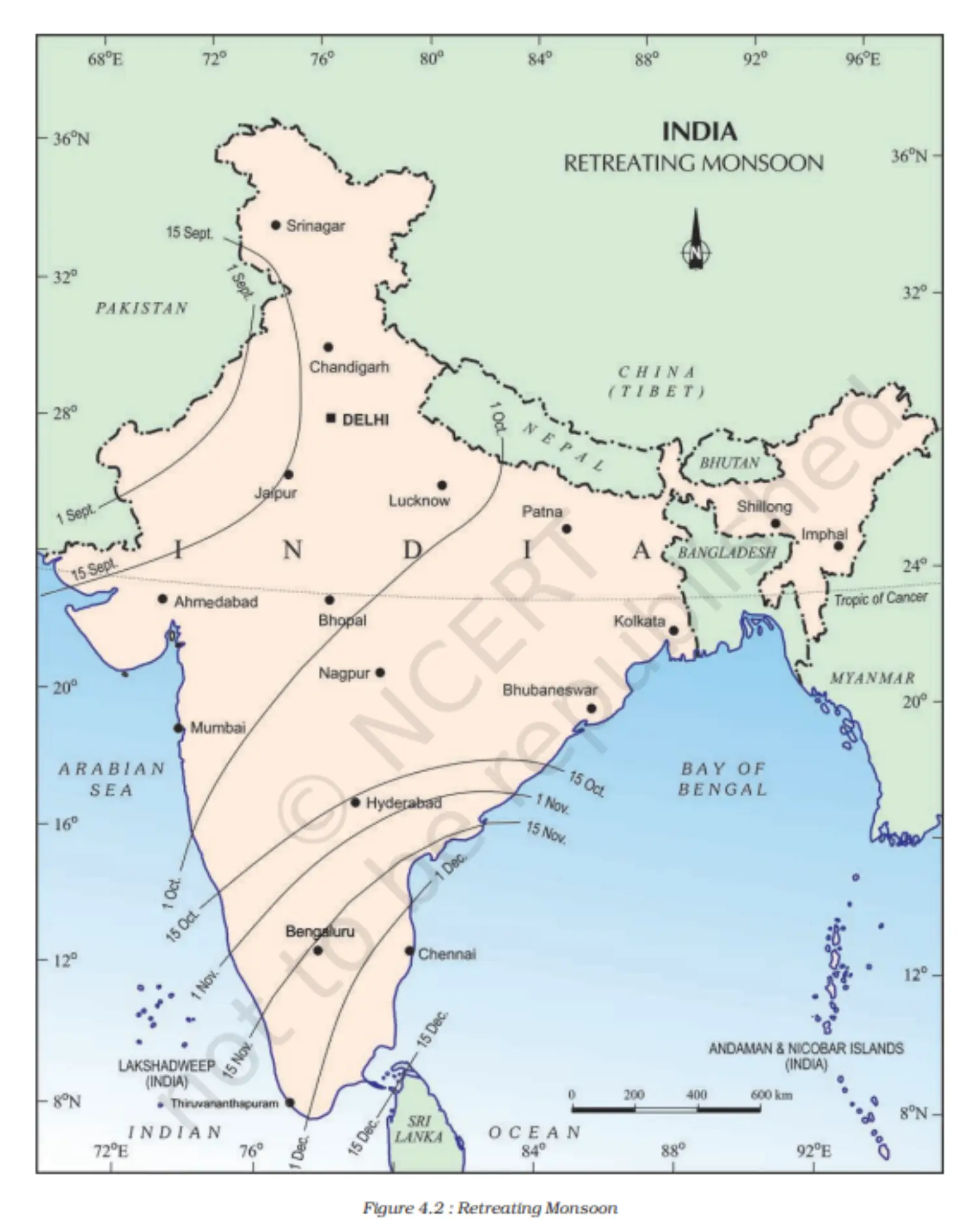
(4) Retreating Monsoon (Transition Season)
- Time: October-November.
- Marked by the withdrawal of the southwest monsoon.
- Features: 'October heat'. The transition from rainy to dry conditions.
- Cyclonic depressions from the Andaman Sea bring rain to the eastern coasts.
Map 1
Map 2
Distribution of Rainfall
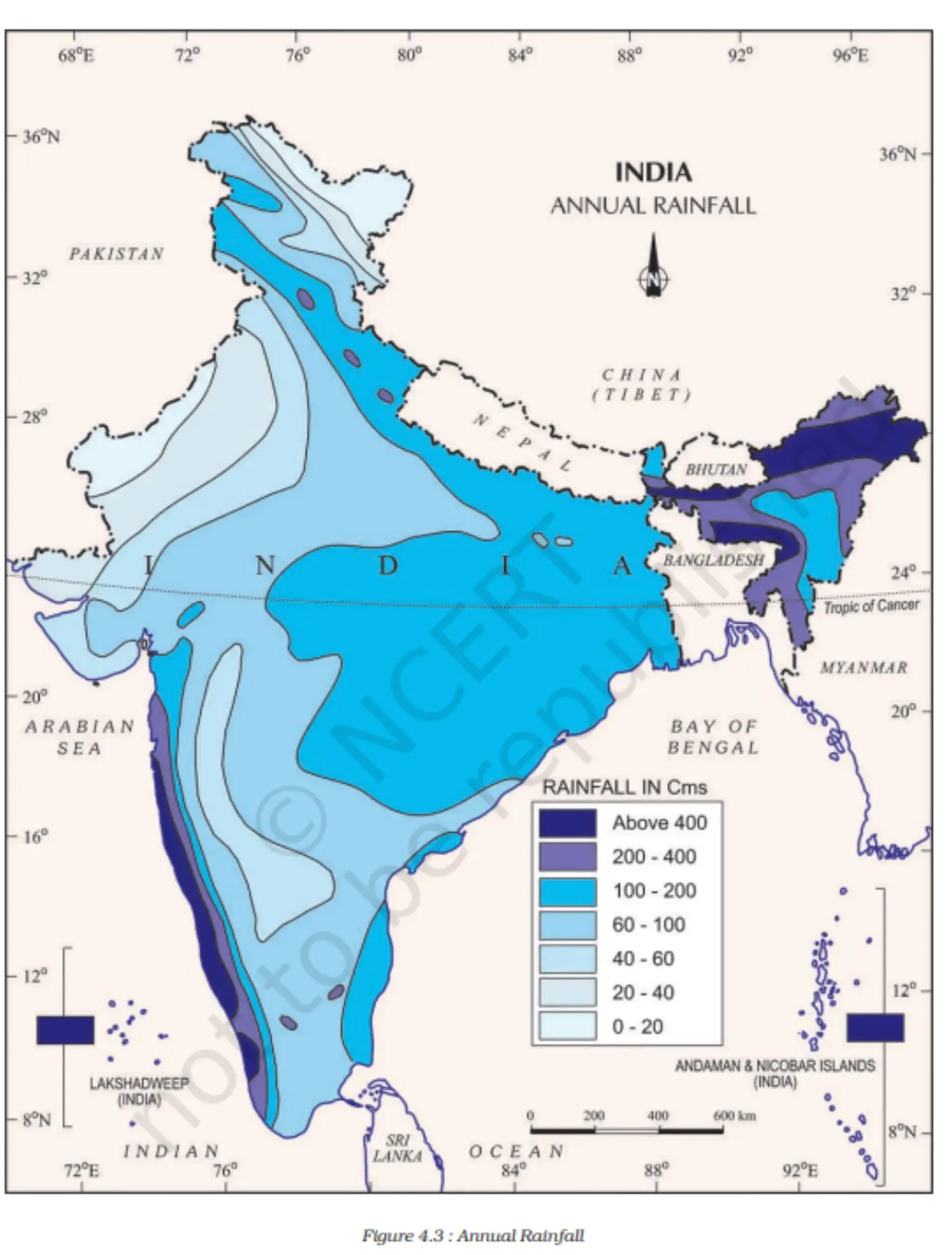
1. Distribution of Rainfall in India
(1) High Rainfall Areas:
- Western coast and northeastern India.
- Receive over 400 cm annually.
(2) Low Rainfall Areas:
- Western Rajasthan, parts of Gujarat, Haryana, and Punjab.
- Rainfall is less than 60 cm.
- Interior Deccan plateau and east of the Sahyadris also receive low rainfall.
- Around Leh in Jammu and Kashmir.
(3) Moderate Rainfall Areas:
- The majority of the country.
(4) Snowfall:
- Restricted to the Himalayan region.
(5) Variability:
- Annual rainfall varies year to year.
- High variability in low rainfall areas.
- High-rainfall areas are prone to floods.
- Low-rainfall areas are prone to droughts.
Map
Monsoon as a Unifying Bond
- (1) Protective Role of Himalayas:
- Shields India from extremely cold Central Asian winds.
- Results in higher temperatures in northern India.
- (2) Peninsular Plateau Influence:
- Surrounded by seas on three sides leading to moderate temperatures.
- (3) Temperature Variations:
- Despite moderating influences, India sees significant temperature differences.
- (4) Unifying Influence of Monsoon:
- Brings a rhythmic cycle of seasons.
- Uncertainty and uneven distribution are monsoon characteristics.
- (5) Cultural and Agricultural Influence:
- Indian landscape, flora, fauna, agriculture, and festivities revolve around the monsoon.
- (6) Eager Anticipation:
- People across India await the monsoon's arrival every year.
- (7) Water's Unifying Role:
- Monsoon provides water, initiating agricultural activities.
- River valleys unite the country, functioning as a single unit.
- (1) Protective Role of Himalayas:
Additional Concepts
1. Origin of the term 'Monsoon'
- Derived from the Arabic word ‘Musam’, meaning 'season'.
- Represents seasonal wind direction reversal.
2. Temperature Fluctuations
- (a) Day and Night Variations in Thar Desert:
- Day temperatures can rise to 50°C.
- Night temperatures can drop to around 15°C.
- (b) Minimal Variations in Coastal Regions:
- Places like Andaman and Nicobar Islands or Kerala have negligible day-night temperature differences.
3. Coriolis Force
- Caused by Earth's rotation.
- Deflects winds to the right in the northern hemisphere and left in the southern hemisphere.
- Also termed 'Ferrel’s Law'.
4. Mawsynram
- Recognized as the wettest place on Earth.
- Known for its stalagmite and stalactite caves.
- Chapter 5 - Natural Vegetation and Wildlife
Introduction
1. India's Bio-diversity
- India ranks among the 12 mega bio-diversity countries globally.
- Positioned 10th in the world and 4th in Asia concerning plant diversity.
- Boasts around 47,000 plant species.
- Contains approximately 15,000 flowering plants, which is 6% of the world's total.
- Home to nearly 90,000 animal species.
- Abundant fish species in both fresh and marine waters.
2. Natural Vegetation
- Plants that grow without human intervention.
- Remained untouched by humans for extended durations.
- Distinct from cultivated crops and orchards.
3. Flora and Fauna
- 'Flora' denotes plants of a specific region or time.
- 'Fauna' refers to animal species of a particular region.
Types of Vegetation
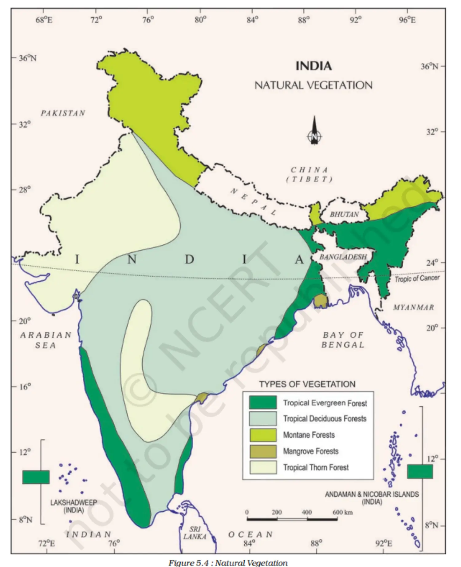
1. Types of Vegetation in India
Tropical Evergreen Forests: Found in high rainfall areas, such as the Western Ghats, islands, and parts of Assam. Characterized by tall trees and greenery throughout the year.
- Notable trees: Ebony, mahogany, rosewood, rubber, cinchona.
- Common animals: Elephant, monkey, lemur, deer, one-horned rhinoceros.
Tropical Deciduous Forests: Most widespread in India, categorized as moist (200-100 cm rainfall) and dry (100-70 cm rainfall).
- Prominent trees: Teak, bamboo, sal, shisham, sandalwood.
- Fauna includes Lion, tiger, pig, deer, elephant, a variety of birds, lizards, and snakes.
Thorn Forests and Scrubs: Located in areas with less than 70 cm of rainfall. Dominated by thorny trees and bushes.
- Main plants: Acacias, palms, euphorbias, cacti.
- Typical animals: Rats, mice, rabbits, fox, wolf, tiger, lion, wild ass, camels.
Montane Forests: Found in mountainous areas with varied vegetation due to altitude changes.
- Wet temperate: 1000-2000 metres, with trees like oaks and chestnuts.
- Temperate forests: 1500-3000 metres, containing coniferous trees such as pine, deodar, and fir.
- Alpine vegetation: Above 3,600 metres, including silver fir, junipers, pines, birches, and alpine grasslands.
- Common animals: Kashmir stag, spotted deer, wild sheep, jackrabbit, Tibetan antelope, yak, snow leopard.
Mangrove Forests: Located in coastal regions influenced by tides.
- Notable trees: Sundari, palm, coconut, keora, agar.
- Found in deltas like Ganga, Mahanadi, Krishna, Godavari, Kaveri
Map
Wildlife
1. India's Rich Fauna
- Approx. 90,000 animal species.
- 2,000 bird species (13% of the world's total).
- 2,546 fish species (12% of the world's stock).
- 5-8% of global amphibians, reptiles, and mammals.
2. Notable Animals
- Mammals: Elephants (Assam, Karnataka, Kerala), one-horned rhinoceroses (Assam, West Bengal), wild ass (Rann of Kachchh), camels (Thar Desert), bison, nilgai, chousingha, gazel, monkeys.
- Big Cats: India has both tigers (Madhya Pradesh, Sundarbans, Himalayas) and lions (Gir forest, Gujarat). Leopards were also prevalent.
- Aquatic: Turtles, crocodiles, gharials.
- Birds: Peacocks, pheasants, ducks, parakeets, cranes, pigeons.
3. Himalayan Fauna
- Yak, Tibetan antelope, bharal, wild sheep, kiang, ibex, bear, snow leopard, red panda.
4. Conservation Challenges
- Imbalance in the ecosystem due to human activities.
- 1,300 plant species endangered; 20 extinct.
- Threat causes: Hunting, pollution, habitat destruction, alien species introduction.
5. Conservation Efforts
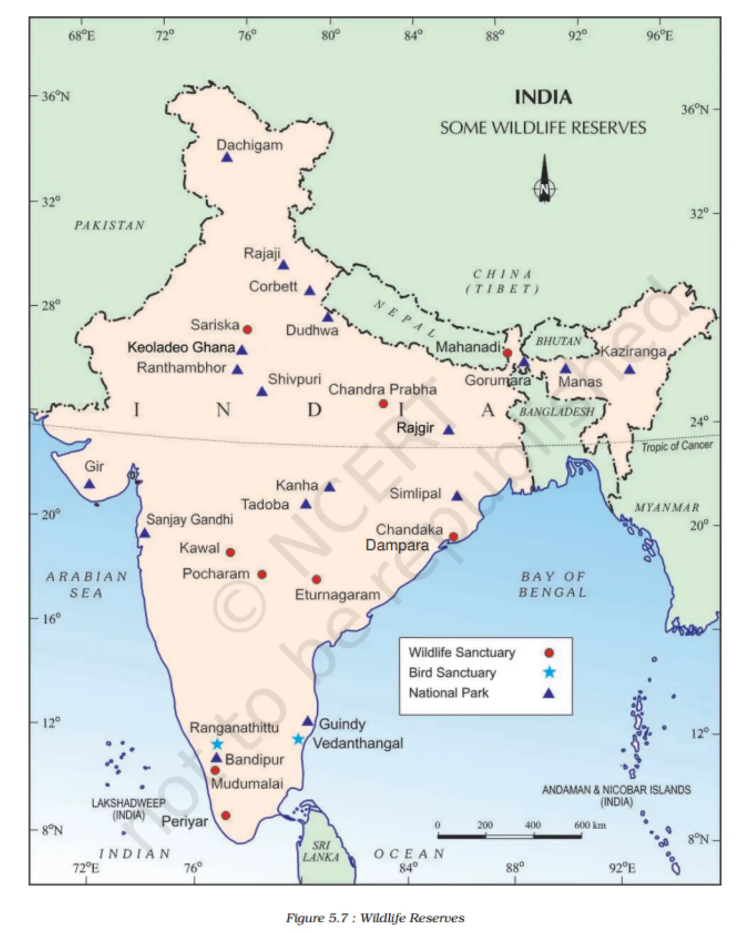
18 biosphere reserves; 12 in the world network.
Projects: Tiger, Rhino, Great Indian Bustard.
103 National Parks, 563 Wildlife sanctuaries, and Zoological gardens.
Map
Additional Concepts
1. Vegetation Types
- Endemic/Indigenous: Original vegetation of India.
- Exotic: Plants that came from outside India.
2. Medicinal Plants
- Historical Context: India known for herbs/spices since ancient times.
- Ayurveda: Describes ~2,000 plants; 500 regularly used.
- Conservation: 352 medicinal plants on the World Conservation Union's Red List.
- Examples:
- Sarpagandha: Treats blood pressure.
- Jamun: Vinegar from ripe fruit has digestive properties; seed powder controls diabetes.
- Arjun: Juice for earache and regulating blood pressure.
- Babool: Leaves for eye sores; gum as a tonic.
- Neem: Antibiotic and antibacterial properties.
- Tulsi: Cures cough and cold.
- Kachnar: Treats asthma, ulcers; buds/roots for digestion.
3. Wildlife Protection
- Wildlife Protection Act: Implemented in India in 1972.
4. Migratory Birds
- Wetlands: Popular with migratory birds in winter.
- Siberian Crane: Visits India during winter.
- Rann of Kachchh: Migratory destination for flamingos.
- Chapter 6 - Population
Introduction
1. Importance of Humans
- Humans give meaning to resources and events.
- Coal, a mere rock, becomes a resource through human technology.
- Natural events (e.g., Tsunamis) are termed 'disasters' when impacting human settlements.
2. Human Perspective in Social Studies
- Population is a pivotal element.
- 'Resources', 'calamities', and 'disasters' derive significance in relation to human beings.
3. Human Role
- Humans are both producers and consumers of Earth's resources.
- Vital to understand population: numbers, distribution, growth, and characteristics.
4. Census Data
- Provides information about a country's population.
Population, Size, and Distribution
1. Population Size and Numbers
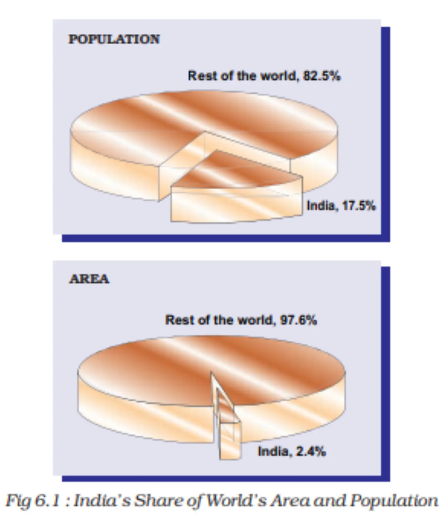
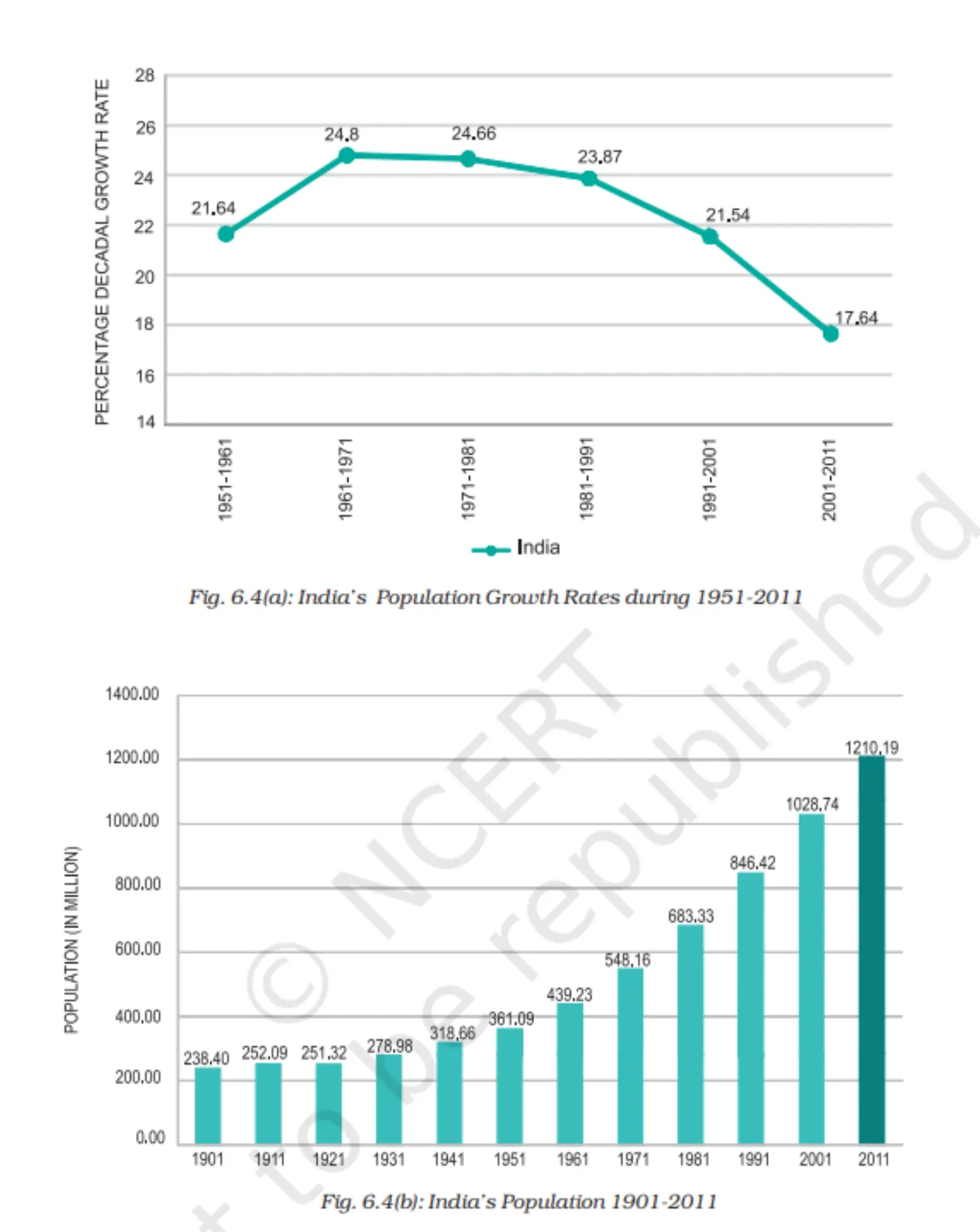
- India's population (2011): 1,210.6 million (17.5% of global population).
- India's area: 3.28 million square km (2.4% of global area).
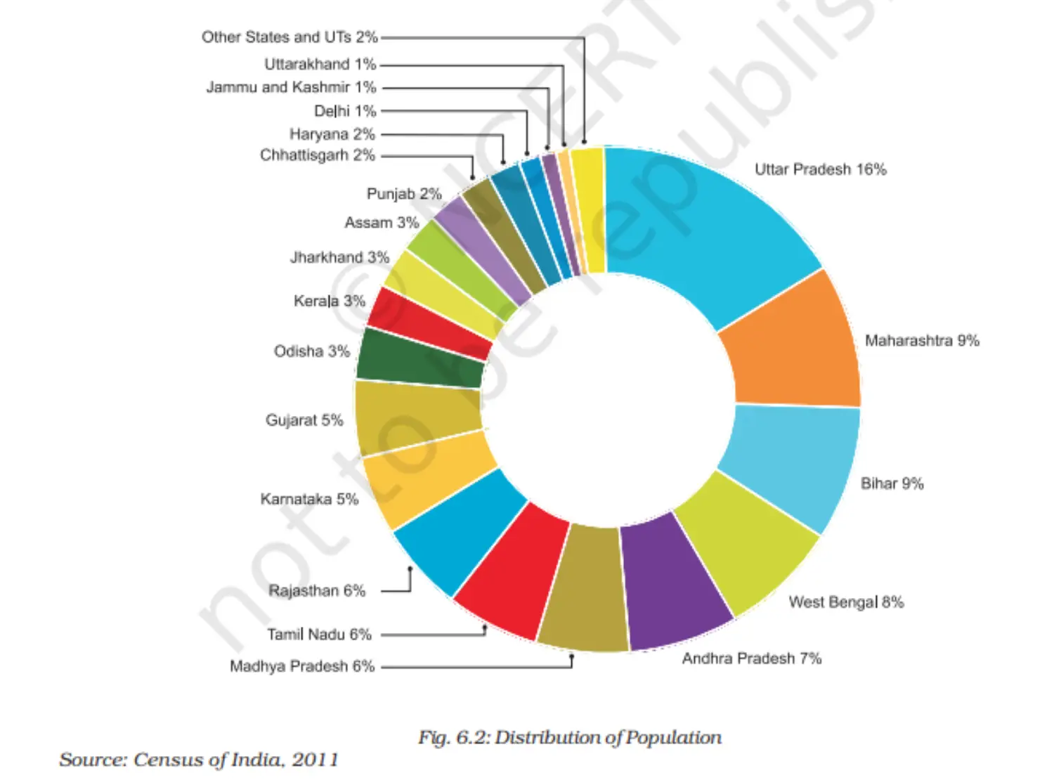
- Uttar Pradesh: Most populous state (199 million, 16% of India's population).
- Sikkim and Lakshadweep: Among the least populated areas.
- 50% of India's population is in five states: Uttar Pradesh, Maharashtra, Bihar, West Bengal, and Andhra Pradesh.
- Rajasthan: Largest state by area but holds only 5.5% of India's population.
2. Population Density
Density: Number of persons per unit area.
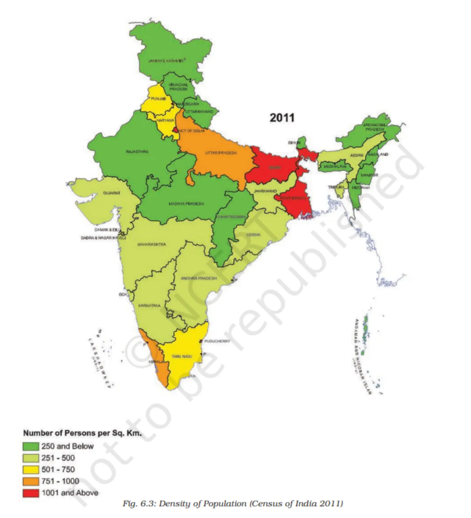
India's density (2011): 382 persons/sq km.
Bihar: Highest density (1,102 persons/sq km).
Arunachal Pradesh: Lowest density (17 persons/sq km).
Factors affecting low density: Rugged terrain, unfavorable climates.
Moderate densities: Assam and many Peninsular states due to terrain and soil conditions.
High densities: Northern plains and Kerala due to fertile soils and good rainfall.
Image 1
Chart
Map
Population Growth and Process of Population Change
1. Population Dynamics
- Population changes due to births, deaths, and migrations.
- Population Growth: Change in population over time.
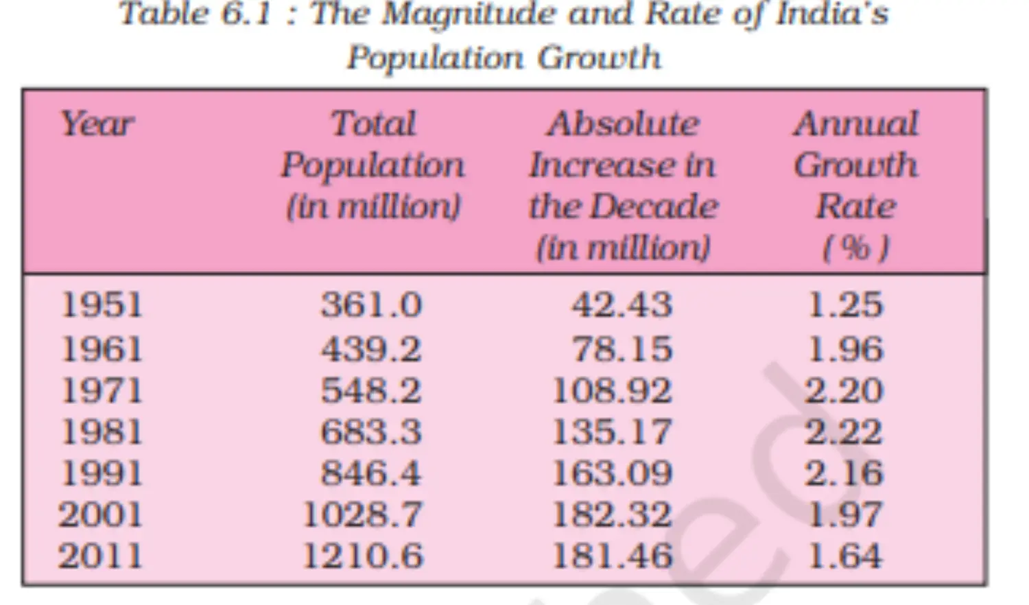
- India's population (2011): 1,210 million.
- The growth rate decreased since 1981 but the absolute number added is still high.
2. Processes of Population Change
- Birth Rates: Number of live births per thousand persons annually.
- High birth rates have always exceeded death rates in India.
- Death Rates: Number of deaths per thousand persons annually.
- The decline in death rates previously led to high population growth.
- Migration: Movement of people across regions.
- Can be internal or international.
- Influences population distribution.
- In India, major migration is from rural to urban due to push (adverse rural conditions) and pull (urban opportunities) factors.
- The urban population rose from 17.29% (1951) to 31.80% (2011).
3. Adolescent Population
- Adolescents (10-19 years) make up one-fifth of India's population.
- Nutrition is crucial for this age group; many face nutritional deficiencies.
- A significant number of adolescent girls suffer from anemia.
4. National Population Policy (NPP) 2000
Recognizes family planning for individual health and welfare.
Aims:
- Free, compulsory school education up to 14 years.
- Reduce infant mortality rate below 30 per 1000 live births.
- Universal child immunization against vaccine-preventable diseases.
- Promote delayed marriage for girls.
- Make family welfare people-centric.
Table
Graph
Additional Concepts
1. Census Overview
- Definition: Official, periodic population count.
- India's Census History:
- Initial Census: 1872 (not complete).
- First Complete Census: 1881.
- Frequency: Every 10 years.
2. Significance of Census
- Offers comprehensive demographic, social, and economic data.
- A valuable reference for various sectors and research.
3. Global Comparison
- Only Bangladesh and Japan have higher average population densities than India.
4. Recent Changes in India's Administrative Units
- 2014: Telangana became India's 29th state.
- 2019: Jammu and Kashmir bifurcated into two union territories - Jammu and Kashmir, and Ladakh.