Class 11: India: physical environment: textbook in geography for class XI, 2006
Section 1 - Introduction
Overview
This unit deals with • Location — space relations and India’s place in the world
Chapter 1 - India - Location
Introduction
INDIA – LOCATION
- Geographical Extent:
- Mainland India spans from Kashmir (north) to Kanniyakumari (south) and Arunachal Pradesh (east) to Gujarat (west).
- Territorial limit extends 12 nautical miles (about 21.9 km) from the coast.
- Measurement Conversion:
- 1 Statute mile = about 1.6 km
- 1 Nautical mile = about 1.8 km
- The southern boundary extends to 6°45' N latitude in the Bay of Bengal.
- Latitudinal and Longitudinal Extent:
- The extent is approximately 30 degrees.
- North-south distance: 3,214 km.
- East-west distance: 2,933 km.
- Reason for Distance Difference:
- Distance between longitudes decreases towards the poles.
- Distance between latitudes remains consistent.
- The southern part lies within the tropics, northern part is in the sub-tropical zone.
- Causes variations in landforms, climate, soil, and vegetation.
- Time Zone and Indian Standard Time (IST):
- 30-degree longitudinal variation causes a two-hour time difference between the easternmost and westernmost parts.
- Despite the time difference, all parts of India follow IST.
- Reason: The country’s standard meridian is 82°30' E longitude.
- IST is 5 hours and 30 minutes ahead of Greenwich Mean Time (GMT).
- Standard Meridian:
- Countries select standard meridians in multiples of 7°30' for uniformity.
- Some countries, like the USA, have multiple time zones due to vast east-to-west extent.
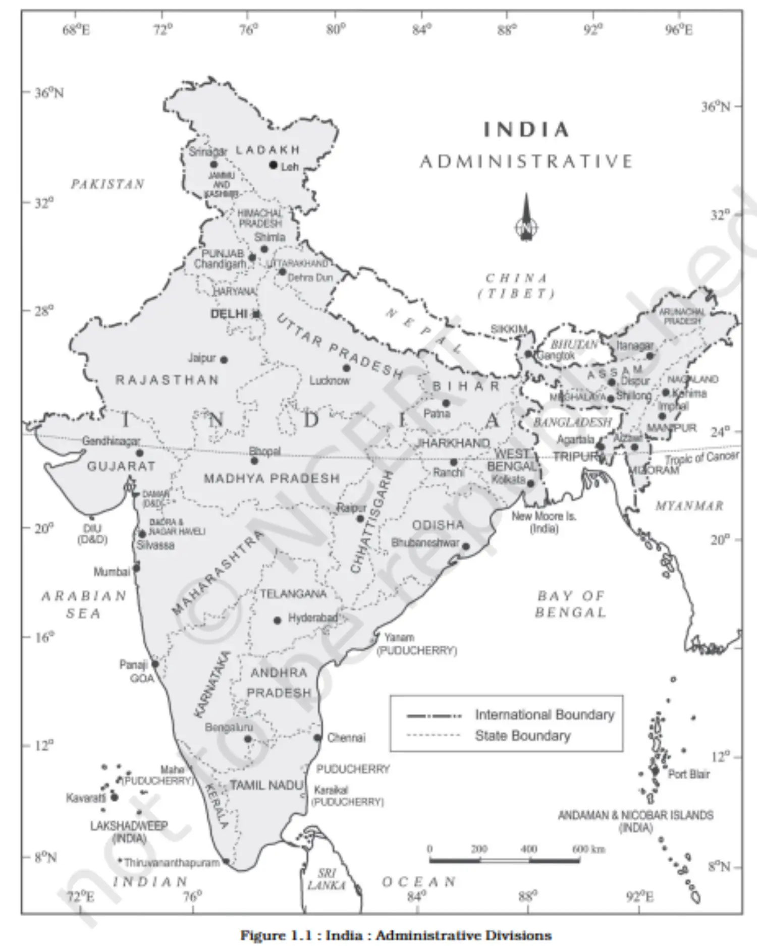
Map - India: Administrative Divisions
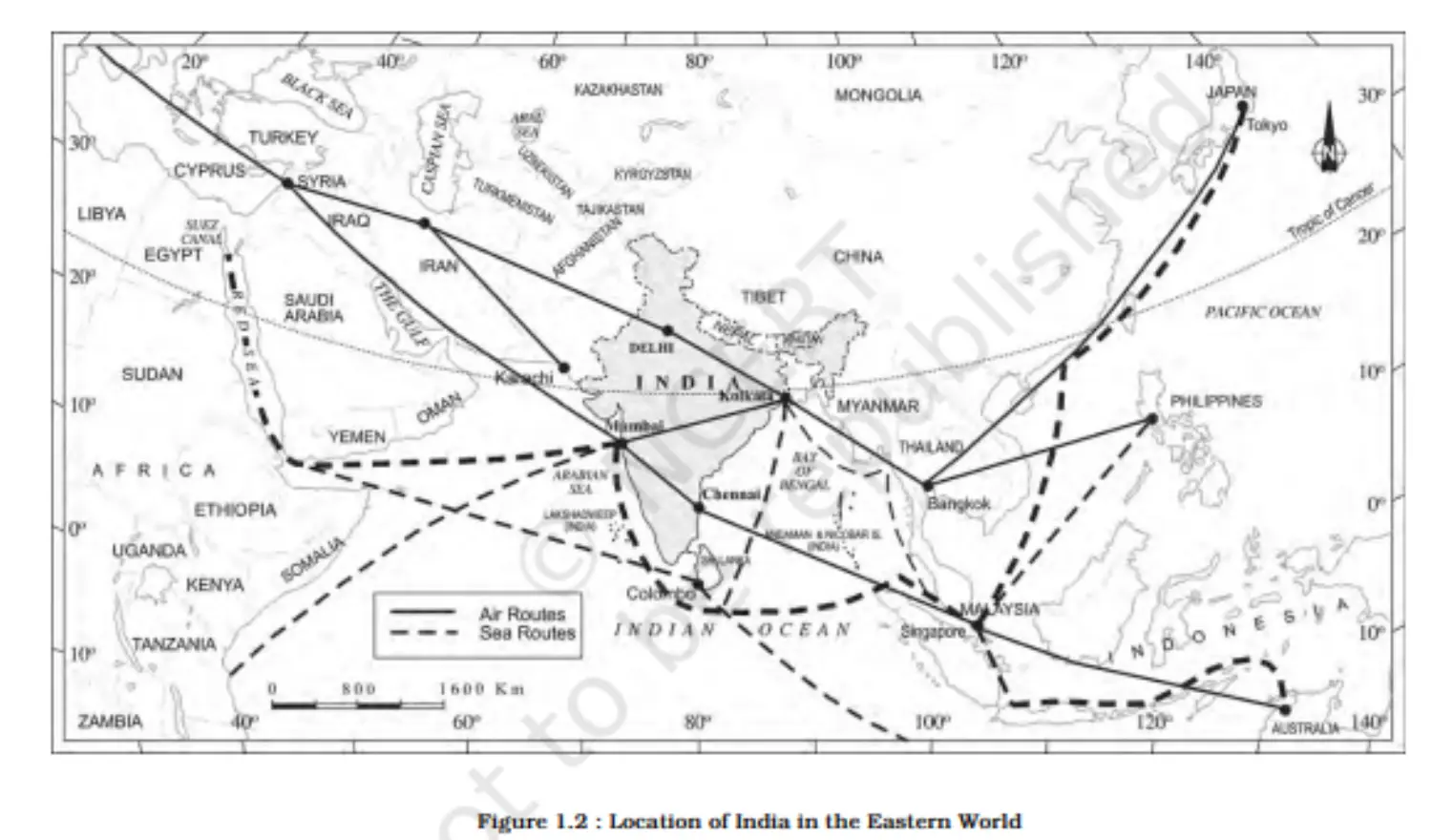
Map - Location of India in the Eastern World
- Geographical Extent:
Sizes
SIZE AND PHYSICAL DIVERSITY OF INDIA
- General Overview:
- India's vast size results in significant physical diversity.
- Presence of mountains, rivers, hills, forests, and deserts.
- Major Features:
- Mountains: Himalayas in the north; Hindukush and Sulaiman ranges in the northwest; Purvachal hills in the northeast.
- Rivers: Ganga, Brahmaputra, Mahanadi, Krishna, Godavari, Kaveri.
- Desert: Marusthali.
- Peninsular Extension: Leads to the Indian Ocean.
- Indian Subcontinent:
- Comprises of countries: India, Pakistan, Nepal, Bhutan, and Bangladesh.
- Unique regional identity evolved due to the formidable barriers like the Himalayas.
- Mountain Passes:
- Few passes like Khyber, Bolan, Shipkila, Nathula, Bomdila, etc.
- Historically acted as gateways through the mountain barriers.
- Coastline:
- Mainland: 6,100 km.
- Including island groups (Andaman and Nicobar, and Lakshadweep): 7,517 km.
- Significance:
- The physical diversity allows for varied resources and unique ecosystems.
- General Overview:
India and the Neighbors
- Location:
- Positioned in the south-central part of the Asian continent.
- Bordered by the Indian Ocean, with extensions into the Bay of Bengal and the Arabian Sea.
- Peninsular India:
- The maritime location has facilitated connections via sea and air routes.
- Neighboring Countries:
- Land neighbors: (Refer to map for a comprehensive list).
- Island neighbors: Sri Lanka and Maldives.
- Sri Lanka: Separated by the Gulf of Mannar and Palk Strait.
- Geographical Terms:
- Gulf: A large water body partially surrounded by land.
- Strait: A narrow passage of water connecting two large water bodies.
- Physical Barriers and Modern Interaction:
- Traditionally, physical barriers might have restricted interactions.
- Modern times: Barriers can be overcome with advancements in technology, transportation, and diplomacy.
- Location:
Section 2 - Physiography
Overview
This unit deals with • Structure and Relief; physiographic divisions • Drainage systems: concept of water sheds — the Himalayan and the Peninsular
Chapter 2 - Structure and Physiography
Introduction
EARTH'S HISTORY AND INDIA'S GEOLOGICAL STRUCTURE
- Earth's Age and Evolution:
- Estimated age: Approximately 460 million years.
- Shaped over time by endogenic and exogenic forces.
- Plate Tectonics:
- The Indian plate was once south of the equator.
- Originally, it was much larger with the Australian plate as part of it.
- Over millions of years:
- The Australian plate drifted southeast.
- The Indian plate moved north.
- The northward movement of the Indian plate is ongoing and affects the physical environment.
- Consequences of the Northward Movement:
- (Refer to the original content for specific consequences or potential student answers).
- Geological Divisions of India:
- Formed through the interplay of endogenic, exogenic forces, and plate movements.
- Three primary geological regions:
- i) The Peninsular Block
- ii) The Himalayas and other Peninsular Mountains
- iii) Indo-Ganga-Brahmaputra Plain
- Earth's Age and Evolution:
The Peninsular Block
- Boundaries & Extensions:
- Northern boundary: Irregular line from Kachchh along the Aravali Range near Delhi, roughly parallel to the Yamuna and Ganga to the Rajmahal Hills and Ganga delta.
- Extensions:
- Northeast: Karbi Anglong, Meghalaya Plateau (separated by Malda fault from Chotanagpur plateau).
- West: Rajasthan (desert regions overlay this block).
- Geological Composition:
- Major part: Ancient gneisses and granites.
- Has stood rigid since the Cambrian period with minor changes.
- Part of the Indo-Australian Plate, experienced vertical movements and block faulting.
- Examples: Rift valleys (Narmada, Tapi, Mahanadi) and Satpura block mountains.
- Mountains & Hills:
- Comprises relict and residual mountains.
- Examples: Aravali hills, Nallamala hills, Javadi hills, Veliconda hills, Palkonda range, Mahendragiri hills.
- River valleys: Shallow with low gradients.
- Rivers & Deltas:
- East-flowing rivers form deltas before entering the Bay of Bengal.
- Important deltas: Mahanadi, Krishna, Kaveri, and Godavari.
- Boundaries & Extensions:
The Himalayan and Other Peninsular Mountains
- Nature & Structure:
- Young, weak, and flexible geological structure.
- Contrasts with the rigid and stable Peninsular Block.
- Tectonic Origin:
- Mountains are tectonically formed.
- Still subjected to interplay of:
- Exogenic forces (external, like weathering)
- Endogenic forces (internal, like tectonics)
- Resulting geological features: faults, folds, thrust plains.
- River Characteristics:
- Fast-flowing rivers in their youthful stage.
- Rivers dissect the mountains, creating various landforms.
- Landforms Indicative of Youthful Stage:
- Gorges
- V-shaped valleys
- Rapids
- Waterfalls
- Nature & Structure:
Indo-Ganga-Bramhaputra Plan
- Formation:
- Comprises plains formed by rivers: Indus, Ganga, and Brahmaputra.
- Originally a geo-synclinal depression.
- Attained maximum development about 64 million years ago during the third phase of the Himalayan formation.
- Sediment Filling:
- Gradually filled by sediments from:
- Himalayan rivers
- Peninsular rivers
- Depth of alluvial deposits: 1,000-2,000 m on average.
- Gradually filled by sediments from:
- Impact of Geological Structure:
- Significant variations across India's regions.
- Influences physiography, relief, and other related aspects.
- Relief and physiography shaped by geological and geomorphological processes in the Indian subcontinent.
- Formation:
Physiography of India
- 1.1. Definition
- Physiography: The natural physical landscape of an area.
- 1.2. Composition
- Determined by structure, process, and developmental stage.
2. Physiographic Divisions
- 2.1. The Northern and North-eastern Mountains
- Rugged topography, mountain ranges, valleys, and gorges.
- 2.2. The Northern Plain
- Extensive flat land, fertile for agriculture.
- 2.3. The Peninsular Plateau
- Stable tableland, dissected plateaus, and denuded rocks.
- 2.4. The Indian Desert
- The arid region, is largely covered by sand dunes.
- 2.5. The Coastal Plains
- Stretch along the coastline, divided into eastern and western plains.
- 2.6. The Islands
- Comprise the Andaman & Nicobar Islands and Lakshadweep.
3. Significance
3.1. Biodiversity
- Supports diverse ecosystems and species.
3.2. Agriculture
- Northern Plains are the granary of India.
3.3. Mineral Resources
- Plateaus are rich in minerals.
The North and Northeastern Mountains
1. Geographic Structure
1.1. Composition
- The region comprises the Himalayas and the Northeastern hills.
1.2. Mountain Ranges
- Parallel ranges include the Greater Himalayas and the Shiwalik.
2. Orientation and Extent
2.1. Direction
- Northwest to southeast in the northwest; east-west in Darjiling and Sikkim; southwest to northwest in Arunachal Pradesh; north-south in Nagaland, Manipur, and Mizoram.
2.2. Size
- The great Himalayan range stretches approximately 2,500 km with a width of 160-400 km.
3. Significance
3.1. Physical Barrier
- Acts as a formidable wall between the Indian subcontinent and Central and East Asia.
3.2. Climatic Divide
- Influences climatic conditions, creating distinct weather patterns on either side.
3.3. Drainage and Cultural Impact
- Affects river systems and cultural interactions.
4. Discussion Points
4.1. Geoenvironmental Impact
- Consider how the Himalayas affect the geo-environment of South Asian countries.
4.2. Global Parallels
- Explore other examples of geoenvironmental divides around the world.
The Northern Plains
1. Formation and Geography
1.1. Rivers: Formed by the Indus, Ganga, and Brahmaputra.
1.2. Extension: Stretches approximately 3,200 km east to west.
1.3. Width: Ranges from 150-300 km.
1.4. Alluvial Depth: Alluvium deposits are between 1,000-2,000 m deep.
2. Sub-regions
2.1. Bhabar: Narrow belt of 8-10 km with heavy material deposits from rivers.
2.2. Tarai: Marshy, swampy area of 10-20 km width, rich in biodiversity.
2.3. Alluvial Plains:
- 2.3.1. Khadar: Newer alluvium; fertile lands.
- 2.3.2. Bhangar: Older alluvium with more developed soil.
3. Fluvial Features
3.1. Sand Bars, Meanders, Oxbow Lakes: Common in these plains.
3.2. Braided Channels: Often found in Brahmaputra plains.
3.3. Deltas: Large deltas like the Sunderbans at river mouths.
4. Elevation and Divides
4.1. Elevation: Generally 50-150 m above sea level.
4.2. Water Divides: Between Indus and Ganga river systems (Haryana and Delhi).
5. The Brahmaputra Course
5.1. Direction: Northeast to the southwest, turning southward at Dhubri.
6. Agricultural and Demographic Significance
6.1. Soil Fertility: Suitable for wheat, rice, sugarcane, and jute.
6.2. Population: Supports a dense population due to fertile land.
The Peninsular Plateau
Not Generated (Prompt may violate the GPT Policy)
The Deccan Plateau
1. Geographical Boundaries
1.1. Western Boundary: Western Ghats.
1.2. Eastern Boundary: Eastern Ghats.
1.3. Northern Boundary: Satpura, Maikal range, and Mahadeo hills.
2. Western Ghats
2.1. Names: Sahyadri (Maharashtra), Nilgiri (Karnataka & Tamil Nadu), Anaimalai & Cardamom (Kerala).
2.2. Elevation: Average of 1,500 m, higher in the south.
2.3. Peaks: Anaimudi (2,695 m) and Dodabetta (2,637 m).
2.4. River Sources: Origin for most Peninsular rivers.
3. Eastern Ghats
3.1. Characteristics: Discontinuous, lower than Western Ghats.
3.2. Erosion: Rivers like Mahanadi, Godavari, Krishna, Kaveri have eroded them.
3.3. Important Ranges: Javadi hills, Palconda range, Nallamala hills, Mahendragiri hills, etc.
4. Confluence of Ghats
4.1. Meeting Point: Eastern and Western Ghats merge at Nilgiri hills.
The Central Highlands
1. Geographical Placement
1.1. Western Edge: Bordered by the Aravali range.
1.2. Southern Boundary: Satpura range, with elevated plateaus.
1.3. Extension: Reaches Jaisalmer, characterized by sand dunes.
2. Geology and Topography
2.1. Elevation: Ranges from 700-1,000 m above sea level.
2.2. Direction of Slope: Slopes towards the north and northeast.
2.3. Geology: Region of metamorphic rocks - marble, slate, gneiss.
2.4. Relict Mountains: Denuded, discontinuous ranges.
3. River Systems
3.1. Yamuna Tributaries: Originate from the Vindhyan and Kaimur ranges.
3.2. Chambal Tributary: Banas, originating from the Aravalli.
4. Eastern Extension
4.1. Rajmahal Hills: Mark the eastern extension of the Central Highlands.
4.2. Below Rajmahal: Chotanagpur plateau, rich in mineral resources.
The Northeastern Plateau
1. Relationship to Peninsular Plateau
1.1. Extension: It's an extension of the Peninsular Plateau.
1.2. Geological Formation: Created from a fault due to the Indian plate's movement.
2. Meghalaya Plateau
2.1. Subdivisions: Comprises the Garo, Khasi, and Jaintia Hills.
2.2. Inhabitants: Named after the tribal groups residing in the area.
2.3. Mineral Rich: Contains coal, iron ore, sillimanite, limestone, and uranium.
3. Erosion and Climate
3.1. Rainfall: Receives heavy rainfall, leading to high erosion.
3.2. Vegetation: Sparse due to erosion; Cherrapunji has a rocky terrain with little permanent vegetation.
4. Karbi Anglong Plateau
4.1. Location: Part of Assam, resembling the Meghalaya plateau.
4.2. Features: Eroded surface with significant mineral deposits.
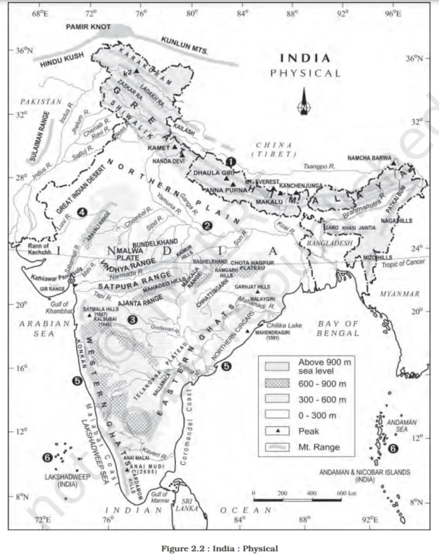
Map
- 1.1. Definition
The Indian Desert
1. Location
- Northwest of the Aravali hills.
2. Topography & Features
- 2.1 Undulating topography.
- 2.2 Longitudinal dunes and barchans.
- 2.3 Characteristics:
- Low rainfall (<150 mm/year).
- Arid climate.
- Low vegetation.
- 2.4 Also known as Marusthali.
3. Historical Significance
- 3.1 Believed to be underwater during the Mesozoic era.
- 3.2 Evidence:
- Wood fossils park at Aakal.
- Marine deposits near Brahmsar, Jaisalmer.
- Wood-fossils age: Approx. 180 million years.
4. Geographical Significance
- 4.1 Rock structure: Extension of the Peninsular Plateau.
- 4.2 Surface features due to:
- Physical weathering.
- Wind actions.
- 4.3 Notable desert features:
- Mushroom rocks.
- Shifting dunes.
- Oasis (mostly southern part).
5. Orientation & Division
- 5.1 Two parts based on orientation:
- Northern: Sloping towards Sindh.
- Southern: Sloping towards the Rann of Kachchh.
6. Rivers & Water Sources
- 6.1 Most rivers: Ephemeral.
- 6.2 Significant river: Luni (in the south).
- 6.3 Water characteristics:
- Low precipitation.
- High evaporation.
- Water deficit region.
- 6.4 Some streams show inland drainage:
- Joining lakes or playas.
- Lakes/playas: Brackish water.
- The main source for obtaining salt.
The Coastal Planes
1. Introduction
- India has a lengthy coastline, divided based on location and geomorphological processes.
2. Western Coastal Plains
- 2.1 Type: Submerged coastal plain.
- 2.2 Historical Significance:
- City of Dwaraka: Once part of the mainland, now submerged.
- 2.3 Features:
- Narrow belt.
- Natural conditions favor the development of ports/harbors.
- 2.4 Major Ports:
- Kandla, Mazagaon, JLN port Nava Sheva, Marmagao, Mangalore, Cochin.
- 2.5 Divisions (from north to south):
- Kachchh & Kathiawar (Gujarat).
- Konkan (Maharashtra).
- Goan coast.
- Malabar coast (Karnataka & Kerala).
- 2.6 Characteristics:
- Narrowest in the middle.
- Broadens towards the north & south.
- Rivers don't form deltas.
- 2.7 Unique Feature of Malabar Coast:
- ‘Kayals’ (backwaters): Used for fishing, inland navigation, and tourism.
- Notable event: Nehru Trophy Vallamkali (boat race) in Punnamada Kayal, Kerala.
3. Eastern Coastal Plains
- 3.1 Type: Emergent coast.
- 3.2 Features:
- Broader than the western coastal plain.
- Well-developed river deltas.
- 3.3 Major Deltas:
- Mahanadi, Godavari, Krishna, Kaveri.
- 3.4 Characteristics:
- Less number of ports/harbours due to emergent nature.
- The continental shelf extends up to 500 km into the sea, making port development challenging.
The Islands
1. Overview
- Two major island groups in India:
- Bay of Bengal.
- Arabian Sea.
2. Bay of Bengal Islands
- 2.1 Number: About 572 islands/islets.
- 2.2 Location: 6°N-14°N latitude & 92°E-94°E longitude.
- 2.3 Principal Islet Groups:
- Ritchie’s archipelago.
- Labrynth island.
- 2.4 Broad Categories:
- Andaman (North)
- Nicobar (South)
- Separated by the Ten-degree channel.
- 2.5 Origin:
- Elevated portion of submarine mountains.
- Some smaller islands are volcanic.
- 2.6 Notable Feature:
- Barren Island - India's only active volcano (Nicobar).
- 2.7 Important Peaks:
- Saddle Peak (North Andaman) - 738m.
- Mount Diavolo (Middle Andaman) - 515m.
- Mount Koyob (South Andaman) - 460m.
- Mount Thuiller (Great Nicobar) - 642m.
- 2.8 Features:
- Coral deposits along the coastline.
- Beautiful beaches.
- Equatorial-type vegetation due to convectional rainfall.
3. Arabian Sea Islands
- 3.1 Main Islands:
- Lakshadweep.
- Minicoy.
- 3.2 Location: 8°N-12°N latitude & 71°E-74°E longitude.
- 3.3 Distance: 280 km-480 km off the Kerala coast.
- 3.4 Origin: Entire group built of coral deposits.
- 3.5 Number: Approx. 36 islands (11 inhabited).
- 3.6 Largest Island: Minicoy (453 sq. km).
- 3.7 Division by Ten-degree channel:
- North: Amini Island.
- South: Canannore Island.
- 3.8 Features:
- Storm beaches with unconsolidated materials on the eastern seaboard.
- Two major island groups in India:
Chapter 3 - Drainage System
Introduction
- 1.1 Drainage: Flow of water through channels.
- 1.2 Drainage System: Network of such channels.
- 1.3 Drainage pattern influenced by geological time, rock structure, topography, slope, water flow, and periodicity.
2. Concepts
- 2.1 Catchment Area: Area drained by a river.
- 2.2 Drainage Basin: Area drained by a river and its tributaries.
- 2.3 Watershed: Boundary separating one drainage basin from another.
- 2.4 Difference: Watersheds are smaller than river basins.
3. Drainage Patterns
- 3.1 Dendritic: Resembles tree branches, e.g., northern plain rivers.
- 3.2 Radial: Rivers flow in all directions from a central point, e.g., Amarkantak range.
- 3.3 Trellis: Primary tributaries flow parallel, and secondary tributaries join at right angles.
- 3.4 Centripetal: Rivers discharge waters from all directions into a lake or depression.
4. Classification of Indian Drainage
- 4.1 Based on Discharge Orientation:
- 4.1.1 Arabian Sea Drainage.
- 4.1.2 Bay of Bengal Drainage.
- 4.2 Based on Watershed Size:
- 4.2.1 Major River Basins (>20,000 sq. km).
- 4.2.2 Medium River Basins (2,000-20,000 sq. km).
- 4.2.3 Minor River Basins (<2,000 sq. km).
- 4.3 Based on Origin & Characteristics:
- 4.3.1 Himalayan Drainage.
- 4.3.2 Peninsular Drainage.
5. Drainage Distribution
- 5.1 77% of drainage towards the Bay of Bengal (e.g., Ganga, Brahmaputra).
- 5.2 23% towards Arabian Sea (e.g., Indus, Narmada).
6. Notable Features
- 6.1 Rivers from the Himalayas & Western Ghats flow towards the Bay of Bengal.
- 6.2 Exceptions: Narmada & Tapi discharge into the Arabian Sea.
- 6.3 Rivers from Konkan to Malabar coast discharge into the Arabian Sea.
Drainage Systems of India
- Overview: India's drainage system is made up of numerous rivers, both small and large.
- Origin & Evolution:
- It's a result of the evolutionary process of three major physiographic units.
- Impact of Precipitation:
- The nature and characteristics of rainfall also play a significant role in shaping the drainage patterns of India.
The Himalayan Drainage
- Overview:
- Evolved over a long geological history.
- Main rivers: Ganga, Indus, and Brahmaputra.
- Characteristics:
- Source: Fed by both melting snow and precipitation.
- Nature: Perennial rivers due to consistent sources.
- Mountain Course:
- Pass through giant gorges.
- Form V-shaped valleys, rapids, and waterfalls.
- Plains Course:
- Depositional features include flat valleys, ox-bow lakes, flood plains, braided channels, and deltas.
- Strong meandering tendency.
- Notable shifts in their courses.
- River Kosi:
- Nickname: 'Sorrow of Bihar'.
- Behavior: Notorious for frequently changing its course.
- Sediment Load: Brings a large amount of sediment from the upper reaches.
- Course Shift: Deposits sediments, which block its path, leading to course changes.
- Overview:
Evolution of the Himalayan Drainage
- Differing Opinions:
- Varied beliefs about the Himalayan river evolution.
- Ancient Mighty River:
- Name: Shiwalik or Indo-Brahma.
- Journey: Spanned from Assam to Punjab, then to Sind.
- Time Period: Miocene period (5-24 million years ago).
- Evidence:
- Continuity of Shiwalik.
- Lacustrine origin and deposits (sands, silt, clay, boulders, conglomerates).
- Dismemberment of Indo-Brahma River:
- Broke into three main systems: (i) Western: Indus and its five tributaries. (ii) Central: Ganga and its Himalayan tributaries. (iii) Eastern: Brahmaputra in Assam and its tributaries.
- Reasons for Dismemberment:
- Pleistocene upheaval in the western Himalayas.
- Uplift of Potwar Plateau (Delhi Ridge) – separated Indus and Ganga systems.
- Down-thrusting of Malda gap (between Rajmahal hills and Meghalaya plateau) in mid-Pleistocene – directed Ganga and Brahmaputra towards the Bay of Bengal.
- Differing Opinions:
The River Systems of the Himalayan Drainage
1. Major Himalayan Rivers
1.1. Indus River System
- Origin
- Tributaries
- Flow and Basin Area
- Economic and Geopolitical significance
1.2. Ganga River System
- Origin
- Tributaries
- Flow and Basin Area
- Cultural and Religious Importance
1.3. Brahmaputra River System
- Origin
- Tributaries
- Flow through Assam and Bangladesh
- Biodiversity and Floods
2. Characteristics of Himalayan Rivers
2.1. Perennial Nature: Glacial and Rainfall-fed
2.2. Youthful Stage: Erosion, Meanders, and Rapids
2.3. Hydroelectric Potential: Due to steep gradients
2.4. Agricultural Significance: Fertile Alluvial Plains
2.5. Seasonal Variation: Influenced by the Monsoon
3. Challenges and Conservation Efforts
3.1. Pollution Control: Initiatives like Namami Gange
3.2. Flood Management: Dams and Embankments
3.3. Sustainable Use: Water Resource Management
3.4. International Cooperation: Trans-boundary Water Treaties
The Indus System
1. Overview
1.1. Basin Size: Covers an area of 1,165,000 sq. km globally, 321,289 sq. km in India.
1.2. Length: Total of 2,880 km, with 1,114 km in India.
2. Origin and Course
2.1. Source: Originates from a glacier near Bokhar Chu in the Tibetan region, Kailash range.
2.2. Tibetan Name: Known as 'Singi Khamban' or Lion's mouth in Tibet.
2.3. Entry to India: Flows northwest, and enters India through Jammu and Kashmir.
2.4. Through Pakistan: Enters Pakistan near Chilas, Dardistan, and discharges into the Arabian Sea east of Karachi.
3. Tributaries
3.1. Himalayan Tributaries: Shyok, Gilgit, Zaskar, Hunza, Nubra, Shigar, Gasting, Dras.
3.2. Right Bank Tributaries: Receives Kabul, Khurram, Tochi, Gomal, Viboa, and Sangar from the Sulaiman range.
3.3. Punjab Rivers (Panjnad): Confluence of Satluj, Beas, Ravi, Chenab, and Jhelum before joining Indus.
4. Major Tributaries' Details
4.1. Jhelum: Rises from Verinag, flows through Srinagar/Wular Lake, and joins Chenab in Pakistan.
4.2. Chenab: The largest tributary, formed by Chandra and Bhaga, joins at Tandi in Himachal Pradesh.
4.3. Ravi: Originates from Kullu hills, flows through Chamba Valley, and joins Chenab in Pakistan.
4.4. Beas: Begins at Beas Kund, flows through Kullu valley, and joins Satluj in Punjab.
4.5. Satluj: Emerges from 'Raksas tal', enters India through Shipki La, significant for Bhakra Nangal Project.
5. Significance
5.1. Geopolitical: Acts as a boundary and water source for India and Pakistan.
5.2. Economic: Supports agriculture and hydroelectric power.
5.3. Cultural: Has historical and religious significance.
The Ganga System
1. Significance
1.1. Cultural and Spiritual: This holds immense cultural and spiritual significance in India.
1.2. Geographical: Extends over a basin of 8.6 lakh sq. km in India.
2. Source and Course
2.1. Origin: Rises at Gangotri Glacier as Bhagirathi becomes Ganga after Devprayag.
2.2. Entry to Plains: Enters plains at Haridwar, and flows through several states before reaching the Bay of Bengal.
3. Major Tributaries
3.1. Left Bank: Ramganga, Gomati, Ghaghara, Gandak, Kosi, Mahananda.
3.2. Right Bank: Son (major tributary), Yamuna (longest tributary).
4. The Yamuna
4.1. Origin: Emerges from Yamunotri glacier.
4.2. Confluence with Ganga: At Prayag (Allahabad).
4.3. Tributaries: Chambal, Sind, Betwa, Ken (right bank); Hindan, Rind, Sengar, Varuna (left bank).
5. Notable Tributaries' Details
5.1. Ghaghara: Joins Ganga at Chhapra.
5.2. Gandak: Originates in Nepal, and joins the Ganga near Patna.
5.3. Kosi: Known as 'Sorrow of Bihar', joins Ganga near Kursela.
5.4. Damodar: Joins Hugli, controlled by Damodar Valley Corporation.
5.5. Mahananda: Joins Ganga in West Bengal.
6. Unique Aspects
6.1. Delta Formation: Forms delta near Sagar Island.
6.2. Cultural Towns: Many holy cities like Haridwar, and Varanasi are on its banks.
7. Hydro Projects and Issues
7.1. Conservation Efforts: Projects like Namami Gange aim to protect the river.
7.2. Challenges: Pollution and sustainable water management are ongoing issues.
The Brahmaputra System
1. Origin and Path
1.1. Source: Originates from Chemayungdung glacier near Mansarovar.
1.2. Tibet Course: Flows as Tsangpo in Tibet; known as 'the purifier'.
1.3. Entry to India: Enters as Siang/Dihang west of Sadiya town in Arunachal Pradesh.
2. Tributaries
2.1. Left Bank: Dibang or Sikang, Lohit, Burhi Dihing, Dhansari (South).
2.2. Right Bank: Subansiri, Kameng, Manas, Sankosh.
2.3. In Bangladesh: Known as Jamuna; merges with Padma, then into the Bay of Bengal.
3. Unique Features
3.1. Dynamic River: Known for its turbulence after emerging from the Himalayas.
3.2. Geomorphology: Characterized by floods, channel shifting, and bank erosion due to heavy sediment load.
4. Issues
4.1. Erosion: The river causes significant erosion, particularly in Assam.
4.2. Flooding: Prone to catastrophic flooding during the monsoon.
5. Hydrological Characteristics
5.1. Sediment Load: Carries a high load of sediments, particularly from its tributaries.
5.2. Rainfall Impact: The catchment area experiences heavy rainfall, contributing to its volume and sediment transport.
6. Cultural and Economic Importance
6.1. Livelihoods: Supports agriculture and fisheries in the Assam valley.
6.2. Navigation: Serves as an important inland waterway.
The Peninsular Drainage System
1. Characteristics
1.1. Age: Older than the Himalayan system; indicated by mature valleys.
1.2. River Maturity: Rivers show broad, graded valleys and less erosive activity.
1.3. Direction of Flow: Primarily west to east, except for Narmada and Tapi.
1.4. Fixed Course: Peninsular rivers follow a stable and consistent path.
1.5. Meandering: Generally absent in these rivers.
1.6. Water Flow: Mostly non-perennial with seasonal flow depending on the monsoon.
2. Water Divide
2.1. Western Ghats: Act as the main water divide for the Peninsular rivers.
3. River Systems
3.1. Ganga Affiliates: Chambal, Sind, Betwa, Ken, Son are part of the Ganga system.
3.2. Eastward Flow: Rivers like Mahanadi, Godavari, Krishna, and Kaveri drain into the Bay of Bengal.
3.3. Rift Valley Rivers: Narmada and Tapi flow through rift valleys, a unique feature among Peninsular rivers.
4. Exceptions
4.1. Narmada and Tapi: Unlike other Peninsular rivers, they flow through rift valleys and have different characteristics like deep valleys and frequent waterfalls.
5. Major Peninsular Rivers
5.1. Mahanadi: Drains into the Bay of Bengal; supports a large delta.
5.2. Godavari: Often referred to as the 'Dakshin Ganga' due to its large size and extent.
5.3. Krishna: Flows across Maharashtra, Karnataka, and Andhra Pradesh.
5.4. Kaveri: Flows through Karnataka and Tamil Nadu; known for its delta region.
The Evolution of the Peninsular Drainage System
1. Geological Influences
1.1. Subsidence:
- The western part of the Peninsula was submerged under the sea in the early tertiary period.
- This event disturbed the symmetrical plan of the drainage.
1.2. Himalayan Uplift:
- The northward tilt due to Himalayan formation caused subsidence and faulting.
- Narmada and Tapi rivers run through these trough faults.
2. Drainage Alterations
2.1. Disrupted Symmetry:
- The original watershed balance was altered due to subsidence.
2.2. River Orientation:
- A northwest-to-southeast tilt directed the drainage towards the Bay of Bengal.
3. River Characteristics
3.1. Narmada and Tapi:
- These rivers lack alluvial and deltaic deposits due to their flow through trough faults.
3.2. Sedimentation:
- The detritus material filled the faults, contributing to the unique river profiles.
4. Tectonic Activity Impact
4.1. Tertiary Period Events:
- Marked by significant tectonic activities that influenced current river courses.
4.2. Peninsular Tilt:
- The tilt of the Peninsula has a profound impact on river flow direction.
River Systems of the Peninsular Drainage
1. Mahanadi River
1.1. Origin: Near Sihawa, Raipur district, Chhattisgarh.
1.2. Length: 851 km, draining into the Bay of Bengal.
1.3. Basin: Spread over 1.42 lakh sq. km.
1.4. States: Flows through Madhya Pradesh, Chhattisgarh, and Odisha.
2. Godavari River
2.1. Nickname: Dakshin Ganga.
2.2. Origin: Nasik district, Maharashtra.
2.3. Length: 1,465 km, ending in the Bay of Bengal.
2.4. Basin: Covers 3.13 lakh sq. km.
2.5. Tributaries: Penganga, Indravati, Pranhita, Manjra.
3. Krishna River
3.1. Origin: Near Mahabaleshwar, Sahyadri.
3.2. Length: 1,401 km.
3.3. Major Tributaries: Koyna, Tungabhadra, Bhima.
3.4. Basin Distribution: Maharashtra, Karnataka, Andhra Pradesh, and Telangana.
4. Kaveri River
4.1. Origin: Brahmagiri Hills, Karnataka.
4.2. Length: 800 km.
4.3. Basin: 81,155 sq. km.
4.4. Tributaries: Kabini, Bhavani, Amravati.
4.5. States: Kerala, Karnataka, Tamil Nadu.
5. Narmada River
5.1. Origin: Amarkantak Plateau.
5.2. Features: Rift valley, Marble Rocks gorge, Dhuandhar Falls.
5.3. Length: 1,312 km, ending in the Arabian Sea.
5.4. Basin: 98,796 sq. km.
5.5. Project: Sardar Sarovar Project.
6. Tapi River
6.1. Origin: Multai, Madhya Pradesh.
6.2. Length: 724 km.
6.3. Basin: 65,145 sq. km.
6.4. Distribution: Maharashtra, Madhya Pradesh, Gujarat.
7. Luni River
7.1. Origin: Near Pushkar, Rajasthan.
7.2. Nature: Ephemeral, with Saraswati and Sabarmati as source branches.
7.3. Course: Flows west, then southwest to the Rann of Kuchchh.
Extent of usability of River Water
- Distribution of River Water:
- Rivers carry huge volumes annually.
- Distribution uneven in time and space.
- Types: (i) Perennial rivers: Flow all year round. (ii) Non-perennial rivers: Limited water during dry season.
- Challenges with Water Distribution:
- Floods in one part while drought in another.
- Main Questions: (i) Is it an availability or management issue? (ii) Can transferring surplus water mitigate problems? (iii) Feasibility of inter-basin linkage or river linking.
- Inter-basin Linkage:
- Linking rivers might help distribute water.
- Challenges: (i) Terrain unevenness. (ii) Lifting water from plain to plateau. (iii) Is there consistent surplus water in northern rivers?
- Problems with River Water Usage:
- (i) Insufficient quantity.
- (ii) River water pollution.
- (iii) Silt load in river water.
- (iv) Uneven seasonal flow.
- (v) Inter-state river water disputes.
- (vi) Shrinking channels due to settlements.
- River Pollution Causes:
- Urban wastewater discharge.
- Industrial effluents.
- Cremation grounds by rivers.
- Festival waste like flowers and statues.
- Bathing and washing.
- Addressing River Pollution:
- Initiatives like the Ganga Action Plan.
- Campaigns for cleaning specific rivers (e.g., Yamuna).
- Distribution of River Water:
Additional Concepts
1. Drainage Systems
1.1. Definition: Drainage refers to the flow of water through channels.
1.2. Drainage Pattern: Influenced by geological structure, topography, and flow of water.
2. Namami Gange Programme
2.1. Objective: Pollution abatement and rejuvenation of the River Ganga.
2.2. Key Pillars:
- Sewerage Treatment Infrastructure
- River-Front Development
- River-Surface Cleaning
- Biodiversity Conservation
- Afforestation Initiatives
- Public Awareness Campaigns
- Industrial Effluent Monitoring
- Ganga Gram Initiative for Village Sanitation
3. River Yamuna
3.1. States Drained: Haryana, Delhi, Uttar Pradesh, and Himachal Pradesh.
4. River Conservation Schemes
4.1. Namami Devi Narmada: For the conservation of the Narmada river.
5. Water Management Projects
5.1. Periyar Diversion Scheme: Diverts water from one watershed to another in Kerala.
5.2. Indira Gandhi Canal Project: Provides water to arid regions of Rajasthan.
5.3. Kurnool-Cuddapah Canal: Irrigation project in Andhra Pradesh.
5.4. Beas-Satluj Link Canal: Diverts water from the Beas to the Satluj River.
5.5. Ganga-Kaveri Link Canal: Proposed project to link the Ganges with the Kaveri River.
Section 3 - Climate and Vegetation
Overview
This unit deals with • Weather and climate – spatial and temporal distribution of temperature, pressure, winds and rainfall; Indian monsoons: mechanism, onset and variability – spatial and temporal; climatic types • Natural vegetation – forest types and distribution; wild life conservation; biosphere reserves
Chapter 4 - Climate
Introduction
WEATHER AND CLIMATE
- Seasonal Changes:
- Water Consumption: More water is drunk during summer.
- Clothing: (i) Lighter clothes in summer. (ii) Heavy woolens in winter (North India). (iii) No woolens needed in South India. (iv) Mild winters in the Northeast, except hills.
- Weather vs. Climate:
- Weather:
- Momentary state of the atmosphere.
- Changes quickly (daily or weekly).
- Climate:
- Average weather conditions over a long period.
- Changes are slow, noticeable after decades.
- Weather:
- Monsoon:
- Previously studied in earlier classes.
- Definition: Climate associated with seasonal wind direction reversal.
- Indian Climate: Hot monsoonal climate, common in south and southeast Asia.
- Seasonal Changes:
Unity and Diversity in the Monsoon Climate
- Monsoonal Unity:
- India shares monsoon regime with Southeast Asian region.
- Despite broad unity, regional variations exist.
- Regional Variations:
- Examples: (i) Kerala & Tamil Nadu vs. Uttar Pradesh & Bihar.
- Factors causing variations: (i) Winds (ii) Temperature (iii) Rainfall (iv) Seasonal rhythms (v) Wetness or dryness level
- Temperature Variations:
- Examples: (i) Summer: 55°C in Rajasthan vs. -45°C in Leh. (ii) Churu (Rajasthan) at 50°C vs. Tawang (Arunachal Pradesh) at 19°C in June. (iii) December night: Drass (Ladakh) at -45°C vs. Thiruvananthapuram or Chennai at 20°-22°C.
- Day-Night Variations: (i) Kerala & Andaman Islands: 7-8°C difference. (ii) Thar Desert: Day at 50°C & Night at 15°-20°C.
- Precipitation Variations:
- Type: Snowfall in the Himalayas vs. Rain elsewhere.
- Amount: (i) Cherrapunji & Mawsynram: >1,080 cm/year. (ii) Jaisalmer: <9 cm/year. (iii) Tura (Garo Hills): Rainfall in one day equals 10 years of rainfall at Jaisalmer.
- Regions: (i) Northwest Himalayas & western deserts: <10 cm. (ii) Meghalaya: >400 cm.
- Storms & Rain Patterns: (i) Ganga delta & Odisha: Rain-bearing storms in July-August. (ii) Coromandel coast: Dry in July-August, rains in early winter.
- Overall Assessment:
- Despite differences, the Indian climate maintains a monsoonal character and rhythm.
- Monsoonal Unity:
Factors Determining the Climate of India
Latitude
1. Latitudinal Extent
1.1. Tropic of Cancer: Divides India into two climatic zones.
1.2. Northern India: Lies in the sub-tropical and temperate zone.
1.3. Southern India: Falls in the tropical zone, south of the Tropic of Cancer.
2. Climatic Impact
2.1. Tropical Zone
- 2.1.1. Location: Nearer to the equator.
- 2.1.2. Temperature: High throughout the year.
- 2.1.3. Variation: Small daily and annual temperature range.
2.2. Sub-Tropical and Temperate Zone
- 2.2.1. Location: Away from the equator.
- 2.2.2. Climate: Experiences extreme climate conditions.
- 2.2.3. Temperature Range: High daily and annual range.
The Himalayan Mountains
1. Climatic Barrier
1.1. Geographic Role: Northern natural barrier for the subcontinent.
1.2. Protection: Shields the subcontinent from cold northern winds.
2. Winds and Weather
2.1. Origin of Winds: From the Arctic circle, across central and eastern Asia.
2.2. Monsoon Influence: Himalayas cause monsoon winds to lose moisture within the subcontinent.
Distribution of Land and Water
1. Geographical Setting
1.1. Ocean Proximity: India is surrounded by the Indian Ocean to the south.
1.2. Northern Barrier: Enclosed by high mountain ranges in the north.
2. Heating and Cooling
2.1. Differential Rates: Water bodies heat and cool more slowly than land.
2.2. Impact: Creates varying air pressure zones around the subcontinent.
3. Monsoon Mechanism
3.1. Air Pressure Variation: This leads to changes in wind patterns.
3.2. Seasonal Reversal: Causes the monsoon winds to reverse direction.
Distance from the Sea
- Coastal Climate 1.1. Equable Conditions: Coastal areas like Mumbai and the Konkan coast enjoy moderate weather. 1.2. Minimal Extremes: Limited temperature fluctuations; stable seasonal patterns.
- Inland Climate 2.1. Extreme Weather: Places far from the sea, such as Delhi, Kanpur, and Amritsar, face stark weather contrasts. 2.2. Seasonal Impact: Pronounced seasonal changes influence lifestyle and activities.
- Lifestyle and Climate 3.1. Coastal Lifestyle: Coastal inhabitants are accustomed to a consistent climate. 3.2. Inland Adaptations: Inhabitants of interior regions adapt to significant weather shifts.
Altitude
- General Rule 1.1. Temperature Variation: Temperature typically decreases by 0.6°C for every 100m increase in altitude. 1.2. Air Density: Higher altitudes have thinner air, which contributes to cooler temperatures.
- Comparative Example 2.1. Agra vs. Darjiling: Both cities are on the same latitude but have different January temperatures.
- Agra: 16°C
- Darjiling: 4°C
- Implications of Altitude 3.1. Mountain Climates: Mountainous areas like Darjiling are significantly cooler than the plains. 3.2. Climatic Zones: Altitude creates varied climatic conditions within the same latitudinal range.
Relief
- Influence of Relief on Climate 1.1. Temperature: Varied relief influences regional temperatures. 1.2. Air Pressure: Elevation changes affect air pressure, influencing weather patterns. 1.3. Wind Patterns: Relief features can alter the direction and speed of winds. 1.4. Rainfall Distribution: Mountains can cause orographic rainfall on the windward side and create rain shadows on the leeward side.
- Specific Examples 2.1. Western Ghats:
- Windward Side: Receives heavy rainfall during the monsoon.
- Leeward Side: The southern plateau remains relatively dry. 2.2. Assam: High rainfall due to its position on the windward side of hills.
- Understanding Relief and Rainfall 3.1. Orographic Effect: As moist air ascends the windward side of a mountain range, it cools and condenses to cause rainfall. 3.2. Rain Shadow: Areas on the leeward side of a mountain range receive less rainfall.
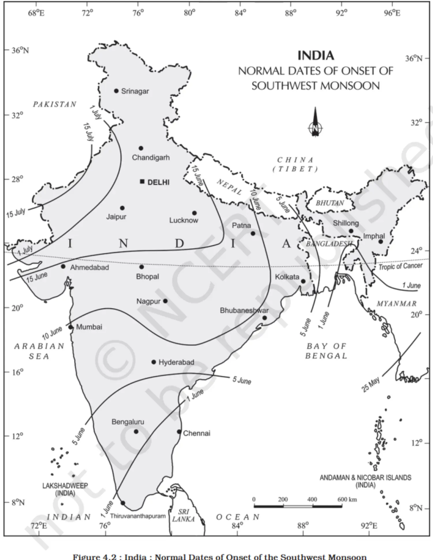
Map
The Nature of the Indian Monsoon
- Complexity of the Monsoon 1.1. Monsoon Enigma: Despite extensive study, the monsoon remains a complex phenomenon not fully explained by a single theory. 1.2. Global Perspective: Recent progress in understanding the monsoon has come from studying it as a global system.
- Key Aspects of the Monsoon 2.1. Onset of Monsoon: The arrival of the monsoon is a significant event, marking the transition from dry to wet season. 2.2. Break in Monsoon: Periods when the monsoon weakens or rain is absent, despite being the rainy season.
- Research and Analysis 3.1. Systematic Studies: Research into South Asian rainfall patterns is crucial for grasping the monsoon's characteristics. 3.2. Causation Theories: Investigations into the causative factors of the monsoon, aiming to provide a comprehensive explanation.
- Onset of the Monsoon
- Mechanism of Onset 1.1. Differential Heating: Land and sea temperature differences during summer set the stage for the monsoon. 1.2. Intense Low Pressure: The subcontinent's heating creates a low-pressure area in the northwest, attracting winds from the high-pressure zone over the Indian Ocean.
- Crossing the Equator 2.1. Trade Winds: Southeast trade winds are drawn towards the low pressure, crossing the equator between 40°E and 60°E. 2.2. ITCZ Shift: The Inter-Tropical Convergence Zone (ITCZ) shifts northward, influencing the monsoon's direction.
- Jet Streams and Monsoon 3.1. Westerly Jet Stream Withdrawal: Its retreat from the North Indian plain is crucial for the monsoon's arrival. 3.2. Easterly Jet Stream: Establishes along 15°N after the westerly jet stream recedes, triggering the monsoon.
- Progression Across India 4.1. Beginning at Kerala: The monsoon hits the Kerala coast around June 1st. 4.2. Movement Across India: Advances rapidly to Mumbai by 10th June, reaches Kolkata by 13th June, and covers the entire subcontinent by mid-July.
- Break in the Monsoon
- Definition of Monsoon Break 1.1. Occurs when expected rainfall does not happen for a week or more during the monsoon.
- Causes of Monsoon Break 2.1. In Northern India:
- Infrequent rain-bearing storms.
- Absence or weak position of the monsoon trough or ITCZ. 2.2. Along the West Coast:
- Winds blowing parallel to the coast, leading to decreased rainfall.
The Rhythm of the Season
- Annual Cycle of Seasons
- India experiences four main seasons, each with distinct weather patterns.
- Seasons Recognised by Meteorologists 2.1. The Cold Weather Season
- Characterized by a drop in temperature and occasional rainfall due to western disturbances. 2.2. The Hot Weather Season
- Marked by rising temperatures and heatwaves; precedes the monsoon. 2.3. The Southwest Monsoon Season
- Brings the majority of the annual rainfall, vital for agriculture. 2.4. The Retreating Monsoon Season
- Transition phase with decreasing rainfall and a return to the dry season.
- The Cold Weather Season
- Temperature
- Overview
- The cold season begins in mid-November in northern India, with December and January being the coldest months.
- Temperature Patterns 2.1. Northern Plains
- Mean daily temperatures stay below 21°C.
- Nights can get particularly cold, with temperatures sometimes falling below freezing. 2.2. Reasons for Cold
- Continental climate due to distance from the sea.
- Snowfall in Himalayas leading to cold waves.
- Cold winds from the Caspian Sea and Turkmenistan in February.
- Peninsular India
- Lacks a defined cold weather season.
- Temperature remains relatively stable, with coastal areas influenced by the sea.
- Western Ghats have cooler hills.
- Example: Thiruvanantapuram has temperatures around 21°C in January and 29.5°C in June.
- Overview
- Pressure and Winds
- Pressure Conditions
- Feeble high pressure over the northern plains.
- Lower pressure in South India.
- Isobars of 1019 mb in the northwest and 1013 mb in the far south.
- Wind Patterns 2.1. General Direction
- From northwest high pressure to low pressure over the Indian Ocean. 2.2. Velocity
- Light winds at 3-5 km per hour. 2.3. Influence of Topography
- Westerly or northwesterly in the Ganga Valley.
- Northerly in the Ganga-Brahmaputra delta.
- Northeasterly over the Bay of Bengal.
- Weather Disturbances
- Pleasant weather is sometimes disturbed by shallow cyclonic depressions.
- These originate over the east Mediterranean Sea and move eastwards.
- Moisture is picked up from the Caspian Sea and the Persian Gulf.
- Role of Westerly Jet Streams
- The Westerly Jet Streams steer the depressions towards India.
- Pressure Conditions
- Rainfall
- General Pattern
- Little rainfall due to the dry nature of winter monsoons.
- Anticyclonic circulation over land reduces the chance of precipitation.
- Exceptions to Dry Weather 2.1. Northwestern India
- Weak cyclones from the Mediterranean can cause rainfall.
- Beneficial for rabi crops.
- Snowfall in the lower Himalayas sustains river flow in summer. 2.2. Precipitation Distribution
- Decreases from west to east in plains.
- Decreases from north to south in mountains.
- Delhi's average winter rainfall: ~53 mm.
- Punjab and Bihar: 25 mm and 18 mm, respectively. 2.3. Central India & Northern Peninsula
- Occasional winter rainfall. 2.4. Northeastern India (Arunachal Pradesh & Assam)
- Rainfall ranges between 25 mm and 50 mm during winter. 2.5. Tamil Nadu and Surrounding Regions
- Torrential rainfall due to the northeast monsoon over the coast and adjoining areas in the post-monsoon months.
- General Pattern
- Temperature
- The Hot Weather Season
- Temperature
- Temperature Dynamics
- Rising temperatures from March to June across India.
- Temperature range between 30°-32°°C in most parts of India.
- Regional Variations 2.1. North India
- April to June is extremely hot.
- Temperatures can soar up to 48°°C in the northwest. 2.2. Deccan Plateau
- March sees temperatures around 38°°C. 2.3. Gujarat and Madhya Pradesh
- April experiences temperatures between 38°°C and 43°°C. 2.4. South India
- Milder summer due to the oceanic influence.
- Temperatures range from 26°°C to 32°°C. 2.5. Hills of Western Ghats
- Cooler climate with temperatures below 25°°C. 2.6. Coastal Regions
- Temperature increases from the coast to the interior, not from north to south.
- Daily minimum temperatures rarely drop below 26°°C during summer.
- Temperature Dynamics
- Pressure and Winds
- Atmospheric Conditions
- High temperatures lead to decreased air pressure in northern India.
- ITCZ moves northwards to 25°°N by July, creating a low-pressure trough.
- Wind Patterns 2.1. General Direction
- Southwesterly along the west coast and in West Bengal and Bangladesh.
- Easterly or southeasterly in north Bengal and Bihar. 2.2. Loo Winds
- Hot and dry winds in the afternoon and at night in northwest India. 2.3. Dust Storms
- Common in May across Punjab, Haryana, Eastern Rajasthan, and Uttar Pradesh.
- Offer relief from heat with light rains and cool breezes.
- Weather Changes
- The entry of southwesterly monsoon winds by mid-June initiates the rainy season.
- Moist winds can cause intense local storms with violent winds and heavy rains.
- Atmospheric Conditions
- Temperature
- Annual Cycle of Seasons
The Southwest Monsoon Season
- Temperature and Pressure
- May sees a temperature spike in the northwest, deepening the low-pressure zone.
- By June, this zone attracts southeast trade winds from the Southern Hemisphere.
- Characteristics of Monsoon Winds 2.1. Origin and Path
- Originate in the Indian Ocean, crossing the equator to enter India.
- Gain moisture over warm equatorial waters, becoming southwest monsoons. 2.2. Monsoon Onset
- Known for abrupt starts, with a significant drop in temperature.
- "Burst" of monsoons is marked by heavy rain, thunder, and lightning.
- Coastal onset in early June; interior arrival by early July.
- Temperatures can fall by 5°°C to 8°°C after monsoon onset.
- Monsoon Branches
- Divided into two branches upon nearing India: 3.1. Arabian Sea Branch
- Moves northwest towards the Indian subcontinent. 3.2. Bay of Bengal Branch
- Heads towards the northeast and eastern parts of India.
Monsoon Winds of the Arabian Sea
- Branches and Impact
- The Arabian Sea monsoon winds diverge into three main branches, each with distinct impacts:
- Branches 2.1. Western Ghats Branch
Ascends the Ghats and causes heavy rainfall on the windward side (250-400 cm). The rain-shadow effect east of the Ghats leads to lower rainfall.
Check and compare rainfall in Kozhikode, Mangalore, Pune, and Bengaluru. 2.2. Central India Branch
Moves through the Narmada and Tapi valleys, bringing rainfall to central India.
The Chotanagpur plateau receives about 15 cm of rain from this branch.
Eventually joins with the Bay of Bengal branch in the Ganga plains. 2.3. Saurashtra and Kachchh Branch
Heads towards Saurashtra and Kachchh, then to west Rajasthan and along Aravalis.
Results in scanty rainfall in these regions.
Merges with the Bay of Bengal branch in Punjab and Haryana to rain in the western Himalayas.
Map
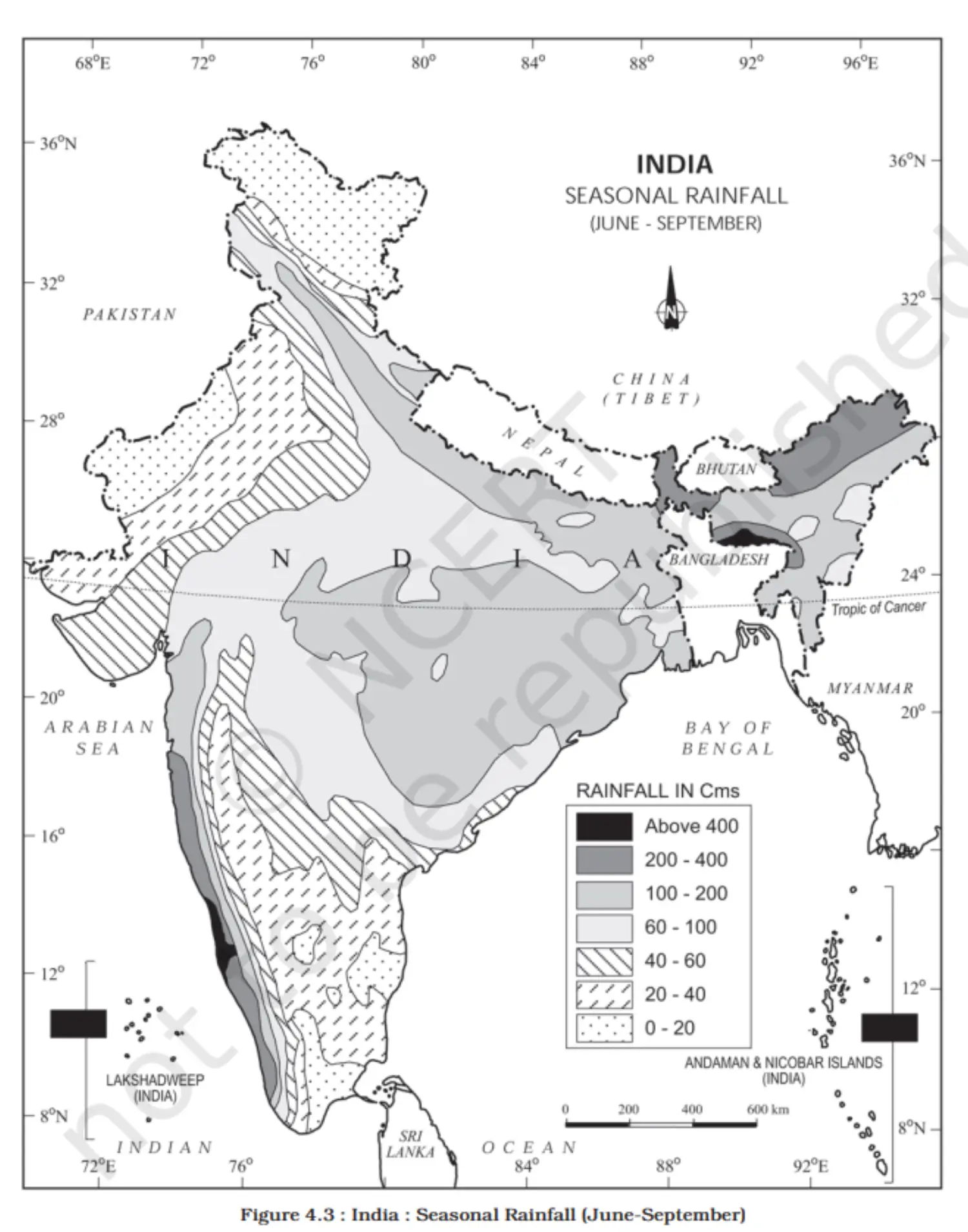
- Branches and Impact
Monsoon Winds of the Bay of Bengal
- Direction and Impact
- The monsoon from the Bay of Bengal is influenced by geographical barriers and splits into branches, each affecting different regions.
- Branches 2.1. West Bengal & Bangladesh Branch
- Enters from the south and southeast, not the typical southwesterly direction.
- Divides into two upon encountering the Himalayas and the thermal low of northwest India. 2.2. Westward Branch
- Travels along the Ganga plains up to the Punjab plains, causing widespread rains. 2.3. Northeastward Branch
- Advances up the Brahmaputra valley, leading to extensive rainfall.
- A sub-branch impacts the Garo and Khasi hills, with Mawsynram recording the highest average annual rainfall globally.
- Tamil Nadu's Dry Season
- The Tamil Nadu coast experiences a dry spell during this season due to: 3.1. Geographical orientation parallel to the Bay of Bengal branch. 3.2. Positioning in the rain-shadow region of the Arabian Sea branch.
- Direction and Impact
Season of Retreating Monsoon
- Timeline
- Monsoon retreats from the western Rajasthan by September's first week.
- By the end of September, it withdrew from the Central Highlands and Western Ganga Plain.
- In October, it moves over the northern Bay of Bengal, and by November, it reaches Karnataka and Tamil Nadu.
- By mid-December, the low-pressure system retreats from the Peninsula.
- Climatic Conditions
- Characterized by clear skies and a temperature rise.
- The phenomenon of 'October heat' is due to high temperature and humidity.
- In northern India, the weather is dry, but the eastern Peninsula receives rainfall.
- Rainfall Patterns
- Eastern Peninsula experiences the rainiest months in October and November.
- Rainfall is due to cyclonic depressions from the Andaman Sea affecting the eastern coast.
- Cyclonic Activity
- Cyclones primarily target the densely populated deltas of the Godavari, Krishna, and Kaveri rivers.
- West Bengal, Bangladesh, and Myanmar also face cyclonic storms.
- The Coromandel coast gets a significant amount of rainfall from these cyclones and depressions.
- Arabian Sea experiences fewer cyclones compared to the Bay of Bengal.
- Timeline
- Temperature and Pressure
Traditional Indian Seasons
- Seasonal Division
- A year is divided into six seasons, each spanning two months.
- Cultural Context
- This classification is based on the traditional knowledge and weather observation by the people of north and central India.
- Regional Variation
- The traditional six-season cycle does not align well with the climatic patterns of south India, which has less pronounced seasonal changes.
Distribution of Rainfall
- Average Annual Rainfall
- India's average is around 125 cm, with significant spatial variations.
- Areas of High Rainfall
- West Coast & Western Ghats: Exceeding 200 cm.
- Northeast: Sub-Himalayan regions and Meghalaya hills with over 200 cm.
- Khasi and Jaintia Hills: Sometimes above 1000 cm.
- Brahmaputra Valley: Slightly less than 200 cm.
- Areas of Medium Rainfall
- Southern Gujarat & East Tamil Nadu: 100-200 cm.
- Northeastern Peninsula: Includes Odisha, Jharkhand, Bihar, and eastern Madhya Pradesh.
- Northern Ganga Plain: Along sub-Himalayas, Cachar Valley, and Manipur.
- Areas of Low Rainfall
- Western Uttar Pradesh, Delhi, Haryana, Punjab, Jammu & Kashmir, Eastern Rajasthan, Gujarat: 50-100 cm.
- Deccan Plateau: Similar range.
- Areas of Inadequate Rainfall
- Peninsular Regions: Andhra Pradesh, Karnataka, Maharashtra, Ladakh, and most of western Rajasthan under 50 cm.
- Snowfall
- Confined to the Himalayan region.
- Task
- Consult the rainfall map to identify and understand the pattern of rainfall distribution.
- Average Annual Rainfall
Monsoons and the Economic Life in India
- Agricultural Dependence
- Monsoon's Role: Central to India's agricultural cycle, crucial for the livelihood of 64% of the population.
- Nationwide Impact: Except for the Himalayas, all regions have temperatures suitable for year-round crop cultivation.
- Regional Crop Diversity
- Climate Variation: Enables the growth of diverse crops across different regions.
- Rainfall Variability
- Droughts and Floods: Irregular rainfall patterns lead to annual water-related challenges.
- Agricultural Impact: Rainfall timing and distribution are key; lack of irrigation exacerbates the issue.
- Soil Erosion
- Monsoon Burst: Can lead to significant soil erosion, affecting land quality.
- Winter Rainfall
- Rabi Crops: Beneficial winter rains from temperate cyclones support the growth of rabi crops in North India.
- Cultural Diversity
- Regional Climates: Influence the variety of food, clothing, and housing across India.
- Agricultural Dependence
Table
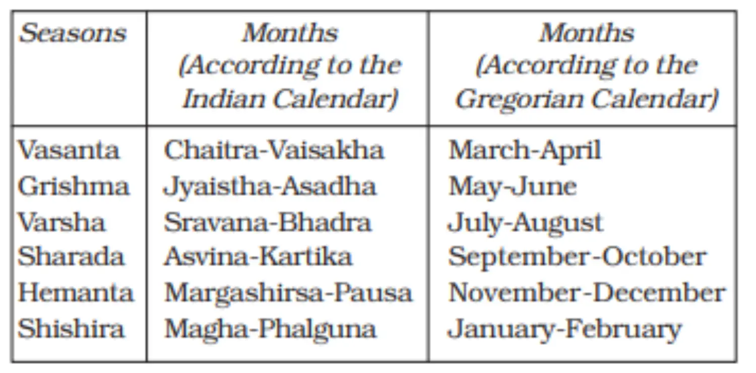
- Seasonal Division
Global Warming
- Background:
- Climate has witnessed changes both globally and locally.
- Geological evidence suggests large parts of Earth were once ice-covered.
- Current Concerns:
- Human Activities: Major contributors to global warming.
- Large scale industrialization.
- Emission of polluting gases.
- Green House Effect:
- Caused by "greenhouse gases".
- Significant temperature rise globally.
- Primary gas: Carbon dioxide (from burning fossil fuels).
- Other gases: Methane, chlorofluorocarbons, nitrous oxide (more potent than carbon dioxide).
- Human Activities: Major contributors to global warming.
- Consequences of Global Warming:
- Melting of polar ice caps and mountain glaciers.
- Increase in ocean water levels.
- The rise in average global temperature:
- The past 150 years saw the temperature rise.
- Predicted 2°C rise by 2100.
- Sea level rise:
- Predicted 48 cm rise by end of 21st century.
- Increased annual flooding incidents.
- Shifts in climatic boundaries:
- Some regions becoming wetter, others drier.
- Agricultural shifts.
- Impact on human population and ecosystems.
- Spread of insect-borne diseases (e.g., malaria).
- Implication:
A rise in sea level by 50 cm could significantly impact Indian sea coasts.
Map
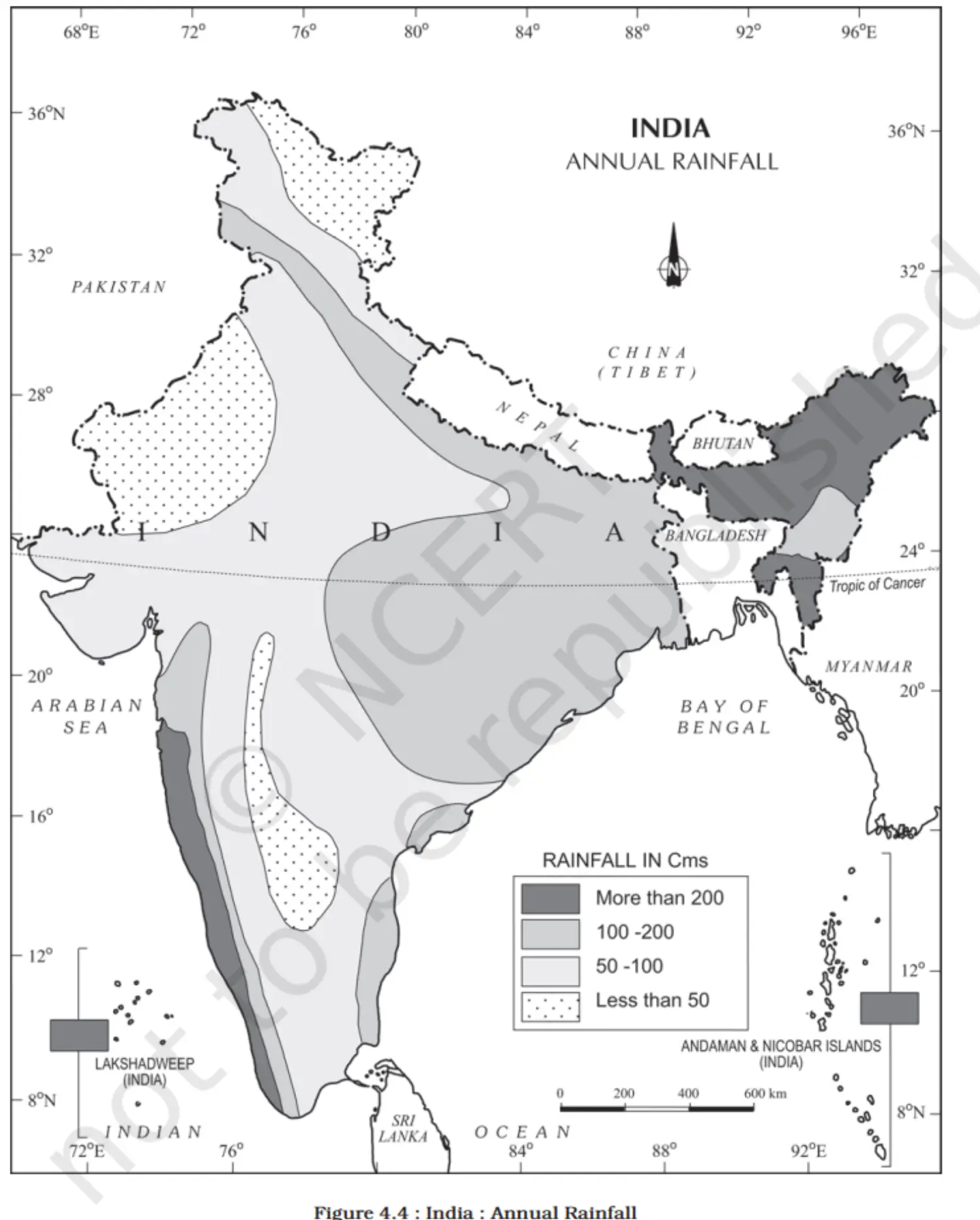
- Background:
Additional Concepts
- Weather vs. Climate
- Weather: Short-term atmospheric conditions.
- Climate: Long-term average of weather patterns, noticeable over 50 years or more.
- Inter-Tropical Convergence Zone (ITCZ)
- Definition: A low-pressure belt at the equator with converging trade winds, causing ascending air.
- Seasonal Shifts:
- Summer: ITCZ near 20°N-25°N, influencing monsoon trough and thermal low over India.
- Winter: ITCZ moves southward, leading to northeast monsoon winds.
- El-Nino and Indian Monsoon
- Phenomenon: Occurs every 3-7 years, affecting global weather including Indian monsoon.
- Effects:
- Disruption of atmospheric circulation.
- Evaporation irregularities.
- Decline in sea life due to warmer currents.
- Monsoon Mechanism
- Research: Based on data from land, sea, and atmosphere.
- Southern Oscillation: Wind intensity measured by pressure differences between Tahiti and Darwin.
- IMD Forecasting: Uses 16 indicators for predicting monsoon behavior.
- Local Storms in Hot Weather Season
- Mango Showers: Pre-monsoon showers aiding mango ripening in Kerala and Karnataka.
- Blossom Showers: Trigger coffee flowering in Kerala.
- Nor'westers (Kalbaisakhi): Thunderstorms beneficial for crops in Bengal and Assam.
- Loo: Hot winds affecting North India, intense between Delhi and Patna.
- Weather vs. Climate
Chapter 5 - Natural Vegetation
Introduction
- Introduction:
- Differentiation between natural vegetation and planted vegetation.
- Natural vegetation grows wild without human intervention, while planted vegetation is grown under human supervision.
- Definition of Natural Vegetation:
- Plant communities are left undisturbed over a long time.
- Allows species to adjust to climate and soil conditions fully.
- Diversity in India:
- India has a vast variety of natural vegetation due to its diverse climate and topography.
- Examples:
- Himalayas: Temperate vegetation.
- Western Ghats & Andaman Nicobar Islands: Tropical rainforests.
- Deltaic regions: Tropical forests and mangroves.
- Rajasthan: Desert vegetation (cacti, bushes, thorny plants).
- Factors Affecting Vegetation:
- Climate and soil are primary determinants.
- Vegetation varies regionally based on these factors.
- Classification:
- Vegetation can be classified based on predominant vegetation type and climatic regions (Note: The provided content does not elaborate further on this classification).
- Introduction:
Types of Forests
- Tropical Evergreen and Semi-Evergreen Forests
- Found in warm and humid areas with rainfall over 200 cm.
- Evergreen forests: Dense and green year-round.
- Semi-evergreen forests: Mix of evergreen and moist deciduous trees.
- Tropical Deciduous Forests
- Also known as Monsoon forests.
- Divided into moist and dry deciduous based on rainfall.
- Shed leaves in the dry season to conserve water.
- Tropical Thorn Forests
- Occur in areas with less than 70 cm of rainfall.
- Consist of thorny trees and bushes.
- Adapted to long dry seasons.
- Montane Forests
- Found in mountainous areas.
- Sub-divided based on altitude:
- Wet temperate forests at 1,000-2,000 meters.
- Temperate forests at 1,500-3,000 meters with conifers.
- Alpine forests above 3,600 meters.
- Littoral and Swamp Forests
- Located along the coast and on islands.
- Adapted to saline water.
- Include mangroves and tidal forests.
- Tropical Evergreen and Semi-Evergreen Forests
- Location
- Western Ghats: Western slope.
- Northeastern Region: Hilly areas.
- Andaman & Nicobar Islands: Coastal and island regions.
- Climate Conditions
- Rainfall: Over 200 cm annually.
- Temperature: Mean annual temperature above 22°C.
- Tropical Evergreen Forests
- Stratification: Multiple layers of vegetation.
- Height: Trees can reach over 60 meters.
- Evergreen Nature: No specific leaf-shedding season, appear green year-round.
- Species: Includes rosewood, mahogany, aini, ebony, etc.
- Semi-Evergreen Forests
- Location: Less rainy parts of the above regions.
- Composition: Mix of evergreen and moist deciduous trees.
- Undergrowth: Presence of climbers that maintain the evergreen character.
- Main Species: White cedar, hollock, kail.
- Impact of British Colonialism
- Exploitation: Large scale exploitation for economic value.
- Forest Structure Change: Oak forests replaced by pine for railway lines.
- Introduction of Plantations: Tea, rubber, and coffee plantations introduced.
- Construction Material: Timber used extensively in construction.
- Shift in Use: From protectional to commercial use.
- Location
- Tropical Deciduous Forests
- General Overview
- Common Name: Monsoon forests.
- Extent: Most widespread forest type in India.
- Rainfall Requirement: Between 70-200 cm.
- Subcategories
- Moist Deciduous Forests
- Rainfall: Between 100-200 cm.
- Locations: Northeastern states, foothills of the Himalayas, eastern Western Ghats, and Odisha.
- Main Species: Teak, sal, shisham, hurra, mahua, amla, semul, kusum, sandalwood.
- Dry Deciduous Forests
- Rainfall: Between 70-100 cm.
- Locations: Peninsular plateau, Uttar Pradesh, Bihar, marginally extending to thorn forests.
- Features: Parkland landscape, trees interspersed with grass, appear like grasslands in the dry season.
- Main Species: Tendu, palas, amaltas, bel, khair, axlewood.
- Seasonal Change: Trees shed leaves in the dry season.
- Moist Deciduous Forests
- Challenges
- Rajasthan: Sparse vegetation due to low rainfall and overgrazing.
- General Overview
- Tropical Thorn Forests
- Geographical Spread
- Rainfall: Occur in regions with less than 50 cm of rainfall.
- Locations: Southwest Punjab, Haryana, Rajasthan, Gujarat, Madhya Pradesh, Uttar Pradesh.
- Characteristics
- Vegetation Type: Grasses and shrubs predominantly.
- Appearance: Plants often leafless, presenting a scrub-like vegetation.
- Flora
- Common Species: Babool, ber, wild date palm, khair, neem, khejri, palas.
- Undergrowth: Tussocky grass up to 2 meters in height.
- Geographical Spread
- Montane Forests
- Classification
- Northern Mountain Forests: Himalayan region with varied vegetation with altitude.
- Southern Mountain Forests: Western Ghats, Vindhyas, and Nilgiris with temperate to subtropical vegetation.
- Northern Mountain Forests
- Foothills (up to 1,000 m): Deciduous forests.
- 1,000-2,000 m: Wet temperate forests with evergreen broadleaf trees like oak and chestnut.
- 1,500-1,750 m: Pine forests with Chir Pine.
- Above 2,225 m: Blue pine, spruce, silver firs, junipers.
- 3,000-4,000 m: Transition to Alpine forests and pastures, with mosses and lichens at highest altitudes.
- Vegetation Variation: Southern slopes are denser than northern slopes due to more precipitation.
- Southern Mountain Forests
- Western Ghats and other ranges: Subtropical at lower elevations, temperate at higher altitudes.
- Sholas: Temperate forests in Nilgiris, Anaimalai, and Palani hills.
- Economically Significant Trees: Magnolia, laurel, cinchona, wattle, deodar (construction), chinar, walnut (Kashmir handicrafts).
- Grasslands: Temperate grasslands at certain elevations.
- Classification
- Littoral and Swamp Forests
- Overview
- India's wetlands cover 3.9 million hectares.
- 70% of wetlands are under paddy cultivation.
- Chilika Lake (Odisha) and Keoladeo National Park (Bharatpur) are internationally recognized under the Ramsar Convention.
- Wetland Categories
- South Reservoirs & West Coast Lagoons: Deccan Plateau and southern coast.
- Saline Expanses: Rajasthan, Gujarat, and the Gulf of Kachchh.
- Freshwater Lakes & Reservoirs: Eastward from Gujarat through Rajasthan and Madhya Pradesh.
- East Coast Deltas & Lagoons: Chilika Lake.
- Gangetic Plain Marshes: Freshwater marshes.
- Brahmaputra Floodplains: Northeast India.
- Montane Lakes & Rivers: Kashmir and Ladakh.
- Mangroves & Wetlands: Andaman and Nicobar Islands.
- Mangrove Forests
- Found in salt marshes, tidal creeks, mud flats, and estuaries.
- Cover 6,740 sq. km, 7% of the world's mangrove forests.
- Well-developed in Andaman & Nicobar Islands and Sunderbans of West Bengal.
- Significant mangroves are also in Mahanadi, Godavari, and Krishna deltas.
- These forests face encroachment and require conservation.
- Overview
- Tropical Evergreen and Semi-Evergreen Forests
Forest Conservation
- Introduction
- Forests are crucial for life and the environment, offering many benefits.
- Conservation is essential for humanity's survival and prosperity.
- Forest Conservation Policy
- Initial Policy in 1952: First step towards a systematic approach.
- Revised Policy in 1988: Emphasizes sustainable forest management.
- Objectives of the 1988 Policy
- Geographical Coverage: Aim to bring 33% of India's area under forests.
- Environmental Stability: Restore ecological balance in disturbed areas.
- Natural Heritage: Conserve biodiversity and genetic resources.
- Erosion and Desertification: Combat soil erosion and desert expansion.
- Flood and Drought Mitigation: Reduce the incidence of floods and droughts.
- Afforestation: Enhance forest cover via social forestry on degraded lands.
- Forest Productivity: Increase output to supply timber, fuel, fodder, and food.
- Substitution of Wood: Promote the use of alternatives to wood.
- People's Movement: Mobilize mass participation, especially women, in planting and conserving trees.
- Conservation Measures
- The policy led to initiatives for afforestation, regulating felling, and conserving resources.
Social Forestry
- Definition
- Social forestry refers to the management and growth of forests and the greening of barren lands to aid environmental, social, and rural development.
- Categories (National Commission on Agriculture, 1976)
- Urban Forestry
- Management of trees in urban areas, including green belts, parks, and roadsides.
- Rural Forestry
- Focus on agro-forestry (integration of trees with agriculture) and community forests on public lands.
- Farm Forestry
- Individual farmers grow trees for commercial and subsistence use on their own land.
- Urban Forestry
- Specifics of Each Category
- Urban Forestry
- Trees in cities: green spaces, industrial areas, etc.
- Rural Forestry
- Agro-forestry: Simultaneous cultivation of crops and trees.
- Community-forestry: Tree cultivation on common lands for community use.
- Farm Forestry
- Farm-level tree cultivation for income and resource supply.
- Urban Forestry
- Benefits and Goals
- Enhances environmental quality and provides social benefits.
- Supports rural development and offers resources like food, fodder, and timber.
- Involves the community, including landless individuals, in forest management.
- Definition
Farm Forestry
- Definition of Farm Forestry
- The cultivation of trees by farmers on their own land for commercial and personal use.
- Implementation
- State forest departments provide free seedlings to farmers, encouraging the integration of tree farming with agriculture.
- Utilization of Land
- Trees are grown on various parts of farm land:
- Margins of agricultural fields.
- Grasslands and pastures.
- Adjacent to homes and animal shelters.
- Trees are grown on various parts of farm land:
- Types
- Commercial Farm Forestry
- Focused on profit-making through timber, pulpwood, etc.
- Non-commercial Farm Forestry
- Aimed at self-sufficiency in wood-related needs like fuelwood, fodder, and structural timber.
- Commercial Farm Forestry
- Advantages
- Diversifies farmers' income.
- Improves ecological balance by increasing green cover.
- Provides a sustainable supply of wood products for the farmer's use.
- Definition of Farm Forestry
Map
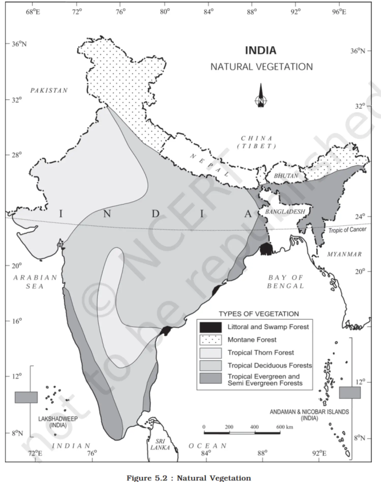
- Introduction
Wildlife
- Introduction:
- India's wildlife is a significant natural heritage.
- Approx. 4-5% of all known plant and animal species are found in India.
- Diversity due to varied ecosystems supported by India.
- Current Challenges:
- Habitat disruption from human activities.
- Many species nearing extinction.
- Reasons for Wildlife Decline: (i) Industrial Growth: Increased exploitation of forest resources. (ii) Land Usage: Clearing for agriculture, settlements, roads, mining, and reservoirs. (iii) Local Pressure: Lopping for fodder, fuelwood, and timber removal by locals. (iv) Grazing: Domestic cattle grazing adversely affects wildlife. (v) Hunting:
- Initially a sport for the elite.
- Currently, commercial poaching is a major issue. (vi) Forest Fires: Damaging habitats and endangering species.
- Significance of Conservation:
- Vital for preserving national and global heritage.
- Promotes ecotourism.
- Introduction:
Wildlife Conservation of India
- Historical Perspective:
- The deep-rooted tradition of wildlife protection in India.
- Influence of stories like Panchtantra and Jungle Books.
- Wildlife Act of 1972:
- Enactment: Comprehensive act for wildlife conservation.
- Objectives: (i) Protect endangered species. (ii) Legal backing for conservation areas: National parks, sanctuaries, closed areas.
- 1991 Amendment: More stringent punishments, protection for specific plant species, and conservation of endangered animals.
- Conservation Areas:
- 101 National Parks.
- 553 Wildlife Sanctuaries.
- Government Initiatives: (i) Collaboration with UNESCO: 'Man and Biosphere Programme'. (ii) Project Tiger (1973):
- Goal: Maintain sustainable tiger populations.
- Initially 9 reserves (16,339 sq. km) expanded to 50 reserves (71,027.10 sq. km).
- Tiger population growth: 1,411 in 2006 to 2,967 in 2020. (iii) Project Elephant (1992):
- Aim: Long-term survival of elephants in natural habitats.
- Implemented in 16 states. (iv) Other Projects: Crocodile Breeding, Project Hangul, Himalayan Musk Deer conservation.
- BIOSPHERE RESERVES:
- Definition: Unique ecosystems, terrestrial and coastal, recognized by UNESCO's MAB Programme.
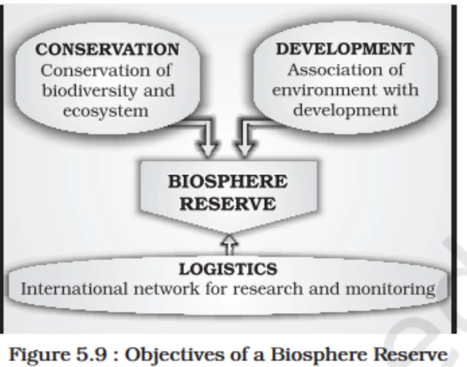
- Objective: Achieve conservation, development, and logistics support.
- India's Contribution:
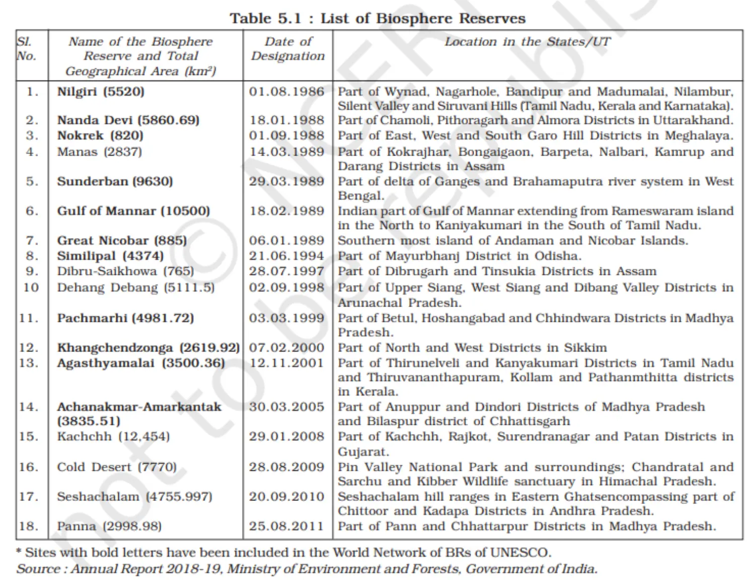
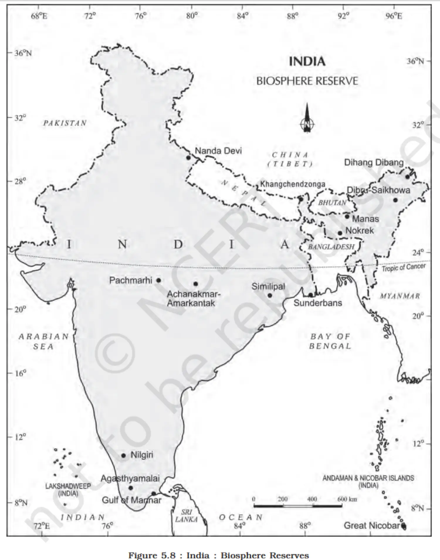
- 18 Biosphere Reserves.
- 11 recognized by UNESCO on the World Network of Biosphere Reserves.
Table
Map
Image
- Historical Perspective:
Additional Concepts
- Interdependence
- Forests serve as the domicile and subsistence source for many tribal communities.
- Tribal Lifestyle and Forest Resources
- Tribals rely on forests for:
- Food: Fruits, leaves, roots, honey.
- Shelter: Materials for housing.
- Culture: Artifacts and tools.
- The forest ecosystem supports their traditional way of life.
- Tribals rely on forests for:
- Tribal Economy
- Forests are integral to the economic framework of tribal societies.
- Tribals often act as collectors of minor forest produce.
- Conservation and Tribal Wisdom
- Tribals possess extensive knowledge of forestry practices.
- Their traditional methods can contribute to sustainable forest management.
- Role Enhancement
- Tribals should be recognized as cultivators and conservators, not just collectors.
- Encouraging tribal participation in forest conservation can lead to improved forest management and betterment of tribal livelihoods.
- Interdependence
Section 4 - Natural Hazards and Disasters: Causes, Consequences and Management
Overview
This unit deals with • Floods and droughts • Earthquakes and tsunami • Cyclones • Landslides
Chapter 6 - Natural Hazards and Disasters
Introduction
WILDLIFE CONSERVATION IN INDIA
- Historical Perspective:
- Deep-rooted tradition of wildlife protection in India.
- Influence of stories like Panchtantra and Jungle Books.
- Wildlife Act of 1972:
- Enactment: Comprehensive act for wildlife conservation.
- Objectives: (i) Protect endangered species. (ii) Legal backing for conservation areas: National parks, sanctuaries, closed areas.
- 1991 Amendment: More stringent punishments, protection for specific plant species, and conservation of endangered animals.
- Conservation Areas:
- 101 National Parks.
- 553 Wildlife Sanctuaries.
- Government Initiatives: (i) Collaboration with UNESCO: 'Man and Biosphere Programme'. (ii) Project Tiger (1973):
- Goal: Maintain sustainable tiger populations.
- Initially 9 reserves (16,339 sq. km) expanded to 50 reserves (71,027.10 sq. km).
- Tiger population growth: 1,411 in 2006 to 2,967 in 2020. (iii) Project Elephant (1992):
- Aim: Long-term survival of elephants in natural habitats.
- Implemented in 16 states. (iv) Other Projects: Crocodile Breeding, Project Hangul, Himalayan Musk Deer conservation.
- BIOSPHERE RESERVES:
- Definition: Unique ecosystems, terrestrial and coastal, recognized by UNESCO's MAB Programme.
- Objective: Achieve conservation, development, and logistics support.
- India's Contribution:
- 18 Biosphere Reserves.
- 11 recognized by UNESCO on the World Network of Biosphere Reserves.
- Historical Perspective:
Classification of Natural Disasters
Background:
- Humans have always experienced and adapted to disasters.
- Awareness has led to steps for disaster mitigation.
- Proper classification assists in efficient disaster management.
Broad Classification of Natural Disasters: (Note: Table 6.2 is referenced but not provided in the initial content. Assuming a generic classification based on typical categories):
(i) Geological Disasters:
- Examples: Earthquakes, volcanic eruptions, landslides.
(ii) Meteorological Disasters:
- Examples: Cyclones, droughts, heatwaves.
(iii) Hydrological Disasters:
- Examples: Floods, tsunamis, avalanches.
(iv) Climatological Disasters:
- Examples: Extreme temperatures, and forest fires.
India's Experience:
- India faces a variety of the disasters listed above.
- Annual losses: Thousands of lives and significant property damage.
- Emphasis on understanding disasters specific to India's context.
Natural Disasters and Hazards in India
- Geographical and Cultural Context
- India is characterized by vast geographical diversity and cultural richness.
- It is often referred to as the 'Indian-subcontinent' and a land of 'unity in diversity'.
- Vulnerability to Natural Disasters
- The combination of extensive natural attributes and a large population increases vulnerability to natural disasters.
- Historical factors like colonial past and social discrimination contribute to this vulnerability.
- Impact of Disasters
- The socio-cultural and physical vastness of India has led to varying impacts of natural disasters across different regions.
Earthquakes
Nature and Unpredictability
- Earthquakes are unpredictable and highly destructive.
- Tectonic movements cause the most devastating earthquakes.
Causes of Tectonic Earthquakes
- Sudden release of energy due to tectonic activities in the earth’s crust.
- The Indian plate's movement is obstructed by the Eurasian plate, causing stress accumulation.
Areas of Influence
- The Himalayan arch is particularly vulnerable.
- High-risk zones include Jammu and Kashmir, Ladakh, Himachal Pradesh, Uttarakhand, Sikkim, parts of West Bengal, and Northeastern states.
- Central-western parts like Gujarat and Maharashtra have also faced severe earthquakes.
Understanding Earthquake Occurrences
- Difficulties in explaining earthquakes in the stable Peninsular India.
- Theories suggest fault lines and energy build-up, particularly along the Bhima river near Latur and Osmanabad.
Risk Zoning in India
- India is divided into five earthquake zones based on risk: (i) Very high damage risk zone (ii) High damage risk zone (iii) Moderate damage risk zone (iv) Low damage risk zone (v) Very low damage risk zone.
Vulnerable Regions
- Very high risk: Northeast states, parts of Bihar, Uttarakhand, Western Himachal Pradesh, Kuchchh in Gujarat.
- High risk: Remaining areas of J&K, Ladakh, Himachal Pradesh, Punjab, Haryana, Delhi, Western UP, Northern Bihar.
- Moderate to very low risk: Other parts, mostly covering the Deccan Plateau.
Socio-Environmental Consequences of Earthquakes
- General Perception
- Earthquakes bring about fear due to their unpredictability and potential for widespread destruction.
- Impact on Populated Areas
- In densely populated regions, earthquakes can cause massive calamities.
- Infrastructure damage: Settlements, transport, communication, and industries are particularly at risk.
- Cultural and Material Loss
- Communities may lose socio-cultural treasures that have been preserved over generations.
- Humanitarian Impact
- Earthquakes can lead to homelessness, creating additional stress for affected populations.
- Developing countries often face heightened challenges due to weaker economies.
- General Perception
Effects of Earthquakes
- Disastrous Impacts
- Earthquakes lead to widespread damage in the affected areas.
- Environmental Consequences
- They can cause significant environmental changes and disturbances.
- Surface Ruptures: Fissures created by seismic waves can cause flooding.
- Landslides: Triggered landslides can block rivers, creating reservoirs.
- River Courses: Altered river courses may lead to unexpected flooding.
Table
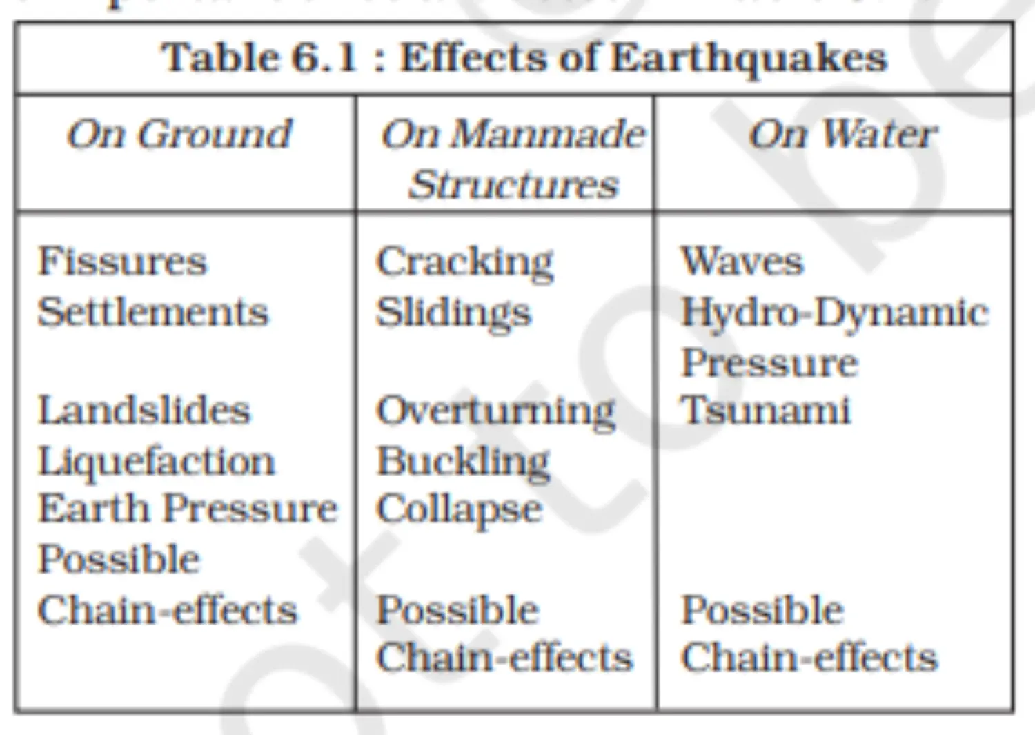
- Disastrous Impacts
Earthquake Hazard Mitigation
- Introduction
- Earthquakes cause devastating damage and complicate relief efforts due to disrupted transport and communication.
- Mitigation Strategies
- Monitoring and Alert Systems
- (i) Implement earthquake monitoring centres for quick information dissemination.
- (ii) Utilize GPS for plate movement monitoring.
- Risk Mapping and Education
- (iii) Create a vulnerability map and share risk information.
- (iv) Educate the public on disaster preparedness.
- Construction and Urban Planning
- (v) Encourage earthquake-resistant buildings in vulnerable areas.
- (vi) Avoid high-rise and large industrial constructions in high-risk zones.
- Regulatory Measures
- (vii) Mandate the use of light materials and resistant designs in construction.
- Monitoring and Alert Systems
Map
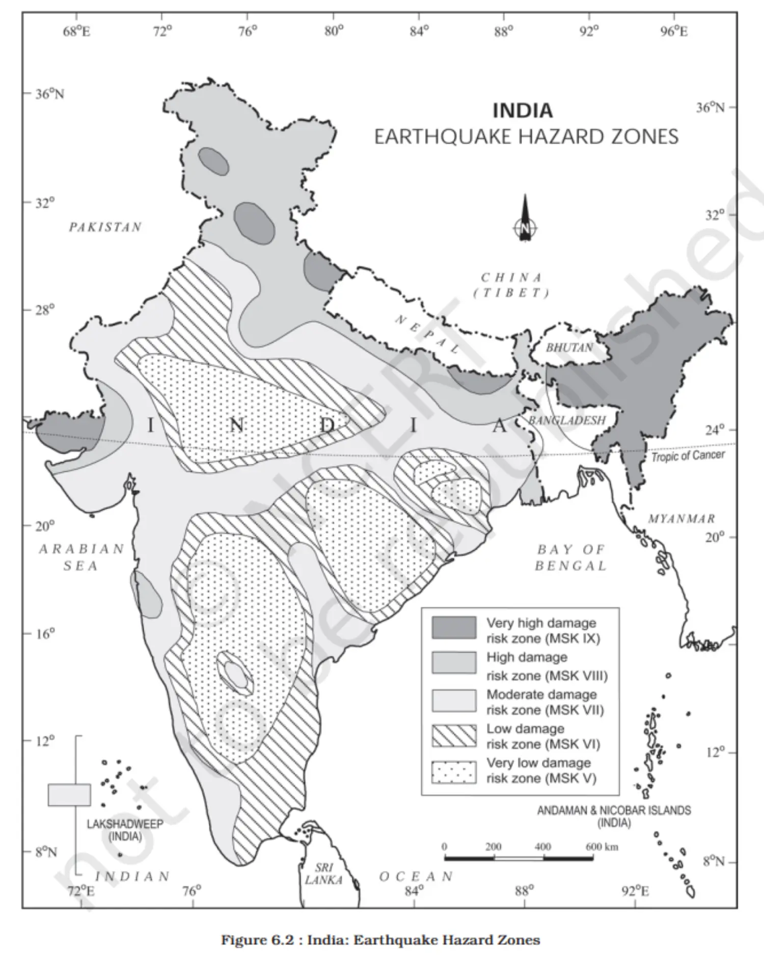
- Introduction
Tsunami
- Definition
- A tsunami is a set of ocean waves caused by any large, abrupt disturbance of the sea-surface.
- Causes
- (i) Earthquakes
- (ii) Volcanic eruptions
- (iii) Underwater landslides
- Characteristics
- Wave Behavior
- (i) Long wavelengths in deep water
- (ii) Height increases in shallow water
- Speed
- (iii) Faster in deep water, slows near coast
- Wave Behavior
- Effects
- (i) Devastation on coastal areas
- (ii) Destruction of infrastructure
- (iii) High loss of life and property
- Geographical Occurrence
- Most common along the Pacific 'Ring of Fire'
- Mitigation Challenges
- (i) Difficult to predict and mitigate
- (ii) Requires international cooperation
- Post-2004 Tsunami
- India joined the International Tsunami Warning System for better preparedness.
- Definition
Tropical Cyclone
- Definition & Structure
- (i) Intense low-pressure systems
- (ii) Confined to 30° N - 30° S latitudes
- (iii) Extend horizontally (500-1,000 km) and vertically (up to 14 km)
- Mechanism
- (i) Driven by latent heat from moisture condensation
- (ii) High-velocity winds circulating around the system
- Initial Conditions for Formation
- Warm, Moist Air Supply
- (i) Necessary for latent heat release
- Coriolis Force
- (ii) Critical for cyclone rotation (absent near the equator)
- Atmospheric Instability
- (iii) Creates disturbances for cyclone development
- Absence of Vertical Wind Wedge
- (iv) Prevents disruption of latent heat transport
- Warm, Moist Air Supply
- Differences in Scientific Opinion
- Despite understanding the conditions, the exact cyclone mechanism is debated.
Spatio-temporal Distribution of Tropical Cyclone in India
- Geographical Influence
- (i) India's peninsular shape influences cyclone patterns.
- (ii) Surrounded by Bay of Bengal (east) and Arabian Sea (west).
- Origin of Cyclones
- Bay of Bengal
- (i) Mainly originates between 10°-15° N during monsoon.
- (ii) Peaks in October-November between 16°-20° N and west of 92° E.
- Arabian Sea
- (i) Lesser frequency compared to the Bay of Bengal.
- Bay of Bengal
- Seasonal Shift
- (i) By July, origin shifts near Sunderban Delta, around 18° N latitude and west of 90° E.
- Geographical Influence
Consequences of Tropical Cyclones
- Energy Source of Cyclones
- (i) Latent heat from warm moist air drives tropical cyclones.
- Impact on Land
- (i) Cyclone intensity decreases with distance from the sea.
- (ii) Coastal areas experience stronger cyclonic storms, up to 180 km/h.
- Storm Surges
- (i) Abnormal sea-level rise during cyclones.
- (ii) Leads to:
- (a) Flooding of human settlements.
- (b) Damage to agricultural lands.
- (c) Destruction of infrastructure.
- Energy Source of Cyclones
Map
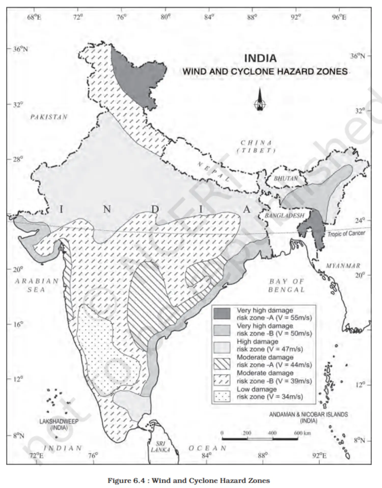
- Definition & Structure
Floods
- Introduction to Floods
- (i) Inundation of land by overflow of water from rivers and streams.
- (ii) Floods have well-identified causes, regions, and seasons.
- Causes of Floods
- (i) Excess surface run-off beyond river capacities.
- (ii) Storm surges in coastal areas.
- (iii) Prolonged high-intensity rainfall.
- (iv) Melting ice and snow.
- (v) Reduced infiltration rate.
- (vi) High soil erosion leading to sediment-laden waters.
- Human Role in Flood Genesis
- (i) Deforestation.
- (ii) Unscientific farming.
- (iii) Blocking natural drainage.
- (iv) Settlement in flood-prone areas.
- Flood-Prone Regions in India
- (i) Assam, West Bengal, Bihar face frequent severe floods.
- (ii) Northern rivers in Punjab, Uttar Pradesh also susceptible.
- (iii) Recent flash floods in Rajasthan, Gujarat, Haryana, Punjab.
- (iv) Tamil Nadu affected during retreating monsoon (Nov-Jan).
- National Flood Commission Findings
- (i) 40 million hectares in India are flood-prone.
- (ii) Significant loss of life and property from recurring floods.
Consequence and Control of Floods
- Consequences of Floods
- (i) Loss of crops and infrastructure damage (roads, rails, bridges).
- (ii) Displacement of millions, loss of lives and livestock.
- (iii) Outbreak of waterborne diseases (cholera, hepatitis).
- (iv) Positive: Deposition of fertile silt on agricultural land.
- Government Response and Flood Control Measures
- (i) Construction of embankments and dams.
- (ii) Afforestation and restriction of construction in flood origins.
- (iii) Removing encroachments from river channels.
- (iv) Depopulating flood plains to reduce human impact.
- (v) Establishment of cyclone relief centers in coastal areas.
- Strategic Regions for Action
- (i) Assam, West Bengal, Bihar, Eastern Uttar Pradesh for river flooding.
- (ii) Coastal areas of Odisha, Andhra Pradesh, Tamil Nadu, Gujarat for cyclones.
- (iii) Punjab, Rajasthan, Northern Gujarat, Haryana for flash floods.
- Consequences of Floods
Map
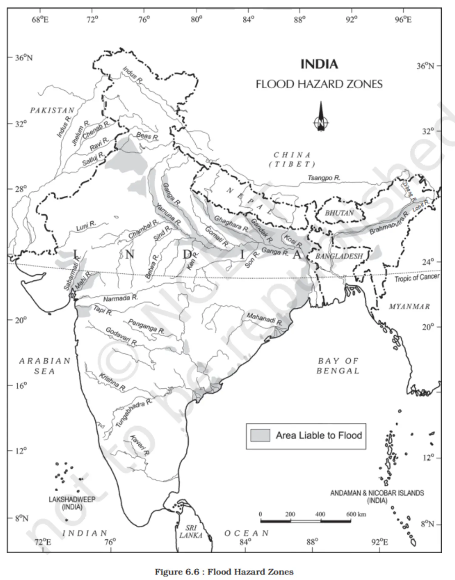
- Introduction to Floods
Droughts
- Definition of Drought
- (i) A prolonged period with a lack of water availability.
- (ii) Results from inadequate rainfall, high evaporation rates, and overuse of water resources.
- Causes of Drought
- (i) Deficient precipitation.
- (ii) Excessive evaporation.
- (iii) Over-extraction from water storages and groundwater.
Types of Droughts
Meteorological Drought
Understanding Meteorological Drought
- (i) Characterized by a lengthy period of insufficient rainfall.
- (ii) Notable for the uneven distribution of rainfall over time and across regions.
Agricultural Drought
- Definition of Agricultural Drought
- (i) Known as soil moisture drought.
- (ii) Occurs when the soil moisture is too low for crop cultivation, leading to crop failure.
- Criteria for Drought-Prone Areas
- (i) An area with more than 30% of its gross cropped area under irrigation is not considered drought-prone.
- Definition of Agricultural Drought
Hydrological Drought
- Definition of Hydrological Drought
- (i) Occurs due to the depletion of water in storages and reservoirs.
- (ii) Happens when water levels in aquifers, lakes, and reservoirs drop below the capacity that precipitation can refill.
- Impact on Water Resources
- (i) Affects the supply for various uses like agricultural irrigation, power generation, and drinking water.
- (ii) Long-term hydrological drought can lead to severe water scarcity and affect ecosystems.
- Definition of Hydrological Drought
Ecological Drought
- Definition of Ecological Drought
- (i) Arises when natural ecosystems suffer from prolonged water shortage.
- (ii) Leads to ecological distress and damage to the ecosystem's productivity.
- Consequences on Ecosystems
- (i) Can result in the loss of biodiversity and disruption of habitats.
- (ii) Affects the ecological balance, impacting flora, fauna, and human livelihoods reliant on these ecosystems.
- Socio-Economic and Ecological Impact in India
- (i) Recurrent in various parts of India, causing widespread socio-economic problems.
- (ii) Ecological problems include degradation of land and loss of wildlife.
- Definition of Ecological Drought
Drought Prone Areas in India
- Dependency on Monsoon
- (i) Indian agriculture relies heavily on monsoon rainfall.
- (ii) Droughts and floods are frequent, contrasting climatic events.
- Drought Statistics
- (i) 19% of India's total geographical area is prone to droughts.
- (ii) 12% of the population is affected by drought annually.
- (iii) 30% of the land is identified as drought-prone, impacting 50 million people.
- Spatial and Temporal Variability
- (i) Some regions face floods while others experience droughts simultaneously.
- (ii) A single region may alternate between flood and drought conditions seasonally.
- Unpredictability of Monsoon
- (i) Monsoon variations lead to unpredictable drought patterns.
- (ii) Droughts are widespread but vary in severity across different regions.
- Severity-Based Regional Division
- (i) India can be divided into different regions based on the severity of droughts.
- (ii) Some areas are more recurrently and severely affected than others.
Extreme Drought Affected Areas
- Geographical Extent
- (i) Mainly in Rajasthan, west of the Aravali hills.
- (ii) Marusthali and Kachchh regions of Gujarat.
- Specific Districts
- (i) Jaisalmer and Barmer in the Indian desert.
- (ii) Receive less than 90 mm average annual rainfall.
- Characteristics of the Region
- (i) Arid conditions with very low precipitation.
- (ii) These areas are among the most drought-prone in India.
- Geographical Extent
Severe Drought Prone Area
- Geographical Coverage
- (i) Eastern Rajasthan
- (ii) Major parts of Madhya Pradesh
- (iii) Eastern Maharashtra
- (iv) Interior regions of Andhra Pradesh and Karnataka Plateau
- (v) Northern interior Tamil Nadu
- (vi) Southern Jharkhand
- (vii) Interior Odisha
- Characteristics of These Regions
- (i) Experience severe drought conditions.
- (ii) Have significant agricultural and rural populations affected by water scarcity.
- Implications
- (i) Frequent water shortages impacting agriculture.
- (ii) Need for drought mitigation and management strategies in these regions.
- Geographical Coverage
Moderate Drought Affected Area
- Geographical Coverage
- (i) Northern Rajasthan
- (ii) Haryana
- (iii) Southern districts of Uttar Pradesh
- (iv) Parts of Gujarat (excluding Konkan)
- (v) Jharkhand
- (vi) Coimbatore plateau of Tamil Nadu
- (vii) Interior Karnataka
- Characteristics of These Regions
- (i) Experience moderate drought conditions.
- (ii) Agriculturally active regions with periodic water scarcity issues.
- Implications
- (i) Regular monitoring and water management needed.
- (ii) Development of drought-resistant agriculture practices.
- (iii) Other parts of India are considered free or less prone to drought.
- Geographical Coverage
Map
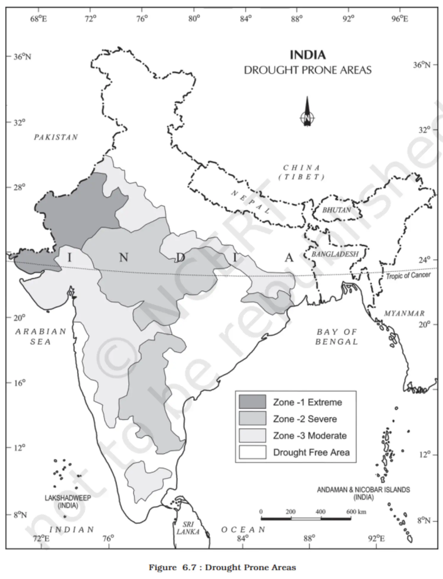
- Dependency on Monsoon
Consequences of Drought
- Immediate Consequences
- (i) Scarcity of food grains (akal), fodder (trinkal), and water (jalkal).
- (ii) Death of cattle and wildlife.
- (iii) Migration of people and livestock.
- (iv) Increase in waterborne diseases due to the use of contaminated water.
- Immediate Response Measures
- (i) Distribute safe drinking water.
- (ii) Provide medical aid to prevent and treat diseases.
- (iii) Ensure the availability of fodder and water for livestock.
- (iv) Relocate affected populations and livestock to safer areas.
- Long-term Strategies
- (i) Identify groundwater potential and aquifers.
- (ii) Plan for river water transfer from surplus to deficit areas.
- (iii) Consider inter-linking of rivers, constructing reservoirs and dams.
- (iv) Use remote sensing for river-basin management and aquifer mapping.
- Drought-Resistant Practices
- (i) Disseminate knowledge about drought-resistant crops.
- (ii) Train farmers in drought-resistant agricultural practices.
- (iii) Promote rainwater harvesting to enhance water availability.
- Immediate Consequences
- Definition of Drought
Landslides
- Introduction
- (i) Landslides are rapid sliding of bedrocks or a large mass of earth.
- (ii) They disrupt transportation and have severe economic impacts.
- Characteristics
- (i) Less dramatic than earthquakes or volcanoes but equally impactful.
- (ii) More predictable due to localized factors.
- Challenges in Monitoring
- (i) Monitoring is difficult and expensive.
- (ii) Requires extensive information on various factors.
- Controlling Factors
- (i) Geology and geomorphic agents.
- (ii) Slope inclination and land-use patterns.
- (iii) Vegetation cover and human activities.
- Zoning in India
- (i) India is categorized into different zones based on landslide susceptibility.
- (ii) This zoning is based on historical data and controlling factors.
- Landslide Vulnerability Zones
- Areas Included
- (i) Young, unstable Himalayan regions.
- (ii) Andaman and Nicobar Islands.
- (iii) Western Ghats and Nilgiris with steep slopes and high rainfall.
- (iv) North-eastern regions.
- Contributing Factors
- (i) Frequent earthquakes that shake the ground.
- (ii) Intense human activities, especially construction-related.
- Human Impact
- (i) Construction of infrastructure like roads and dams increases risk.
- Risk Management
- (i) Close monitoring and strict regulation of construction activities.
- (ii) Implementation of landslide mitigation measures.
- High Vulnerability Zone
- Areas Included
- (i) All Himalayan states.
- (ii) North-eastern states (excluding Assam's plains).
- Vulnerability Factors
- (i) Similar conditions to the very high vulnerability zones.
- (ii) Varying combination, intensity, and frequency of factors.
- Distinguishing Aspects
- (i) Less intense and less frequent controlling factors compared to very high vulnerability zones.
- Preventive Measures
- (i) Regular assessment of vulnerability.
- (ii) Community awareness and preparedness programs.
- Areas Included
- Moderate to Low Vulnerability Zone
- Areas Included
- (i) Trans-Himalayan areas (Ladakh, Spiti).
- (ii) Aravali range.
- (iii) Rain shadow regions of Western and Eastern Ghats.
- (iv) Deccan plateau.
- Precipitation and Stability
- (i) Receive less rainfall.
- (ii) Generally have stable relief.
- Common Landslide Causes
- (i) Mining activities.
- (ii) Subsidence.
- (iii) Occasional heavy rains.
- States Affected
- (i) Jharkhand, Odisha, Chhattisgarh.
- (ii) Madhya Pradesh, Maharashtra.
- (iii) Andhra Pradesh, Karnataka, Tamil Nadu.
- (iv) Goa, Kerala.
- Preventive Measures
- (i) Regulation of mining activities.
- (ii) Monitoring and stabilization of high-risk zones.
- (iii) Public awareness campaigns.
- Areas Included
- Other Areas
- Landslide-Safe Regions
- (i) Rajasthan (excluding hilly regions).
- (ii) Haryana.
- (iii) Uttar Pradesh (excluding hilly areas).
- (iv) Bihar (excluding hilly regions).
- (v) West Bengal (excluding Darjiling).
- (vi) Assam (excluding Karbi Anglong).
- (vii) Coastal regions of southern states.
- Reasons for Safety
- (i) Lack of steep topography.
- (ii) Lesser rainfall intensity.
- (iii) Stable geological conditions.
- Exceptions
- Areas within these states with unique conditions (e.g., hilly or high rainfall areas) may still experience landslides.
- Landslide-Safe Regions
- Areas Included
- Consequences of Landslides
- Direct Impact
- (i) Roadblocks.
- (ii) Destruction of railway lines.
- (iii) River channel blockages from rock falls.
- Secondary Consequences
- (i) Diverted river courses leading to flooding.
- (ii) Loss of life and property.
- Socio-Economic Effects
- (i) Hindered spatial interactions.
- (ii) Increased risk and cost for travel and transport.
- (iii) Adverse effects on local development.
- Direct Impact
- Mitigation
- Restrictive Measures
- (i) Limit construction and development activities (roads, dams).
- (ii) Regulate agriculture to moderate slopes and valley areas.
- (iii) Control settlement development in high-risk zones.
- Positive Actions
- (i) Implement afforestation programmes.
- (ii) Construct bunds to reduce water flow and erosion.
- (iii) Promote terrace farming, especially as an alternative to Jhumming.
- Restrictive Measures
- Introduction
- Geographical and Cultural Context
Disaster Management
Disaster Management Bill, 2005
- Introduction
- Bill defines the term "disaster."
- Definition of Disaster
- A severe event affecting any area, resulting from:
- Natural causes.
- Man-made causes.
- Accidents or negligence.
- The event leads to:
- Significant loss of life.
- Immense human suffering.
- Damage to or destruction of the environment.
- It surpasses the ability of the affected community to cope.
- A severe event affecting any area, resulting from:
- Introduction
Conclusion
Disaster Management Conclusion - Revision Notes
- Introduction
- Disasters can be due to natural causes or human activities.
- Not all hazards necessarily lead to disasters.
- Complete elimination of natural disasters is challenging.
- Objective
- Focus on disaster mitigation and preparedness.
- Stages of Disaster Management
- Pre-disaster Management
- Gather data and information about potential disasters.
- Create vulnerability zoning maps.
- Spread awareness among the population.
- Engage in disaster planning, preparedness, and prevention.
- During Disaster
- Implement rescue and relief operations.
- Prioritize evacuation and construction of shelters.
- Provide essentials like water, food, clothing, and medical aid.
- Post-disaster Management
- Focus on rehabilitation and recovery of victims.
- Build capacity to handle potential future disasters.
- Pre-disaster Management
- Significance for India
- Approximately two-thirds of India's area and population are vulnerable to disasters.
- The Government of India has taken steps like introducing the Disaster Management Bill, 2005.
- Establishment of the National Institute of Disaster Management is a notable initiative.
- Introduction
Additional Concepts
- Observing Environmental Changes
- (i) Identify long-term and short-term environmental changes.
- (ii) Assess the impact: some changes are beneficial, others detrimental.
- Concept of Disaster
- A disaster is a severe, uncontrollable event causing damage and requiring extensive aid.
- Yokohama Strategy and IDNDR
- (i) Yokohama Strategy: a guide for disaster mitigation.
- (ii) Emphasis on developing countries and vulnerable communities.
- (iii) IDNDR (1990-2000): a dedicated decade for reducing disaster impacts.
- Resolutions from the World Conference on Natural Disasters Reduction
- (i) Sovereign responsibility for citizen protection.
- (ii) Focus on developing nations and disadvantaged groups.
- (iii) Strengthening local to international cooperation and capabilities.
- Disaster Elements
- (i) Cyclones: air-sea-land interactions, pressure gradients, and winds.
- (ii) Droughts: involve meteorological and socio-economic factors.
- Disaster Management
- (i) Disaster Management Bill, 2005: defines and sets the framework for dealing with disasters.
- (ii) Encourage community resilience and capacity building.
- Local Initiatives
- Examine and improve local rooftop rainwater harvesting methods.
- Observing Environmental Changes
Glossary
Geographical Terms
- Landforms & Features
- Alluvial Plain: Level land with fine rock material, deposited by rivers.
- Archipelago: Cluster of nearby islands.
- Bedrock: Solid rock under the soil and weathered material.
- Coast: Boundary of land and sea.
- Coastal Plain: Flat land between the coast and inland higher ground.
- Gorge: Deep valley with steep rocky sides.
- Island: Landmass surrounded by water, smaller than a continent.
- Peninsula: Land projecting into the sea.
- Plain: Wide flat or gently undulating land.
- Plateau: Elevated flat land.
- Playa: Flat central area in a drainage basin in low rainfall regions.
- Climatic & Atmospheric Terms
- Arid: Climate with insufficient rainfall for vegetation.
- Climate: Average weather over 30 years for a large area.
- Depression: Low atmospheric pressure area; temperate cyclone.
- Jet Stream: Strong westerly wind below the tropopause.
- Monsoon: Wind reversal causing seasonal change.
- Water Bodies & Features
- Backwater: Slow water stretch, bypassed by mainstream flow.
- Estuary: River mouth where fresh and saltwater mix.
- Glacier: Snow and ice mass moving slowly, carving valleys.
- Lake: Water body in a hollow, surrounded by land.
- Meander: Curve or loop in a river's course.
- Rapids: Swift river water over steep, hard rocks.
- Geological & Soil Terms
- Bunding: Earth or stone embankments for water and soil conservation.
- Calcareous: High calcium carbonate content.
- Coral: Calcium-secreting marine polyp-forming reefs.
- Fold: Rock strata bend from the earth's crust compression.
- Gneiss: Coarse-grained metamorphic rock from heat and pressure.
- Gully Erosion: Soil/rock erosion from concentrated runoff.
- Humus: Soil's dead organic content.
- Landslide: Rock and debris rapid downslope movement due to gravity.
- Soil Profile: Vertical soil section from surface to parent rock.
- Tectonic: Earth-originated forces changing landform features.
- Conservation & Reserves
- Biosphere Reserve: Protected areas for all flora and fauna.
- Conserves natural heritage.
- Promotes ecological research.
- Provides educational facilities.
- Conservation: Protects environment and resources for the future.
- National Park: Area for wildlife protection; no forestry/grazing.
- Protected Forest: Limited protection; activities allowed unless banned.
- Reserved Forest: Full protection; all activities banned unless allowed.
- Sanctuary: Area for animal conservation; limited activities allowed.
- Unclassed Forest: Recorded as forest; ownership varies by state.
- Biosphere Reserve: Protected areas for all flora and fauna.
- Miscellaneous Terms
- Catchment Area: Area drained by a river and its tributaries.
- Fauna: Animal life of a specific area/time.
- Pass: Mountain range route through a gap or col.
- Subcontinent: Large distinct geographical unit in a continent.
- Terai: Marshy ground at the bottom of alluvial fans.
- Landforms & Features