Maps Foundation
Defintion
Strait : Connects Two Water Bodies & Separates Land. (S of Strait Separates Land)
World
- Introduction
5 Oceans
Covers 70% of the earth's surface
- Connection between Bodies
- connects the Pacific Ocean with the Atlantic Ocean
- Natural - Drake Passage
- Man Made - Panama Canal
- Bering Strait
- connection between Pacific Ocean and Arctic Ocean
- Separates USA & Russia
- connects the Pacific Ocean with the Atlantic Ocean
- Pacific Ocean - Largest in Size
- The Pacific Ocean is the largest and the deepest ocean on average
- It is also called as Pacific Ring of Fire
- It is twice the size of the Atlantic Ocean
- The Pacific Ocean has the deepest point in the ocean ie Marian Trench and Mariana Trench has Challenger Deep (10,900 Mts)
- Major country nearest to Challenger Deep is the Philippines; Approximately it has a depth of 10, 994 metres
- Highest Point on Earth is Mt Everest 8848. Hence Highest point on Earth is less than Deepest point on Sea
- Atlantic Ocean - Second Largest in Size
- It is the youngest Ocean 250 million years is its age, becasue of Continental Drift and Sea Floor Spreading.
- It is the 2nd largest ocean and is in S-shape
- The most prominent feature is the Mid-Atlantic Ridge which is also in S-shape
- Indian Ocean - Third Largest in Size
- Only Ocean to be named after a country
- The Indian Ocean is connected to land towards the North
- Responsible for Monsoon and dictates weather of land north to Indian Ocean
Arctic Ocean - Fourth Largest in Size
Arctic Ocean - It is the smallest ocean out of all the 5 oceans
It has no landmass and is covered with ice
The area under the ice is decreasing due to Global warming
The polar bear is the largest land carnivore which is there in the Arctic
Due to Arctic amplification - the impact of Global warming is more as it has a fragile ecosystem
the rate of increase of temperature is high here
According to report of IPCC → Also weakening of Atlantic meridional overturning circulation (AMOC) is taking place → Reduced Intensity of Ocean Currents
Human beings have been existing here for long times; Also
Neanderthals also existed here
- Southern Ocean
- Southern Ocean is the fifth Ocean and is the recent addition i.e in the year 2000 by International Hydrographic Organisation (IHO)
- Rationale - As it does not mix with other waters easily due to westerlies
- Southern Ocean is until 60 degree south latitude
- Unofficially the Southern Ocean is also called Austral Ocean (Meaning of Australis is South) or Antarctica Ocean
- Connection between Bodies
7 Continents
Basic of Continents
- Continents as per Size (in decreasing order)
- Asia
- Africa
- North America
- South America
- Antarctica
- Europe
- Oceania (Australlia)
- No standard and official definition for the continent
- Till the edge of the continental shelf, it is continent and beyond it is part of world oceans
- Asia and Europe
The Ural Mountains as the boundary between Europe and Asia
Caucasus Mountain Region - Armenia, Azerbaijan and Georgia
Turkey connects both Asia and Europe;
Istanbul → earlier Name → Constantinople → Silk Route used to pass through this
Seas - the Caspian Sea, the Black Sea and the Mediterranean Sea
- Asia and Africa
- the Sinai Peninsula is under the control of Egypt
- Asia & Ocenaia
New Guinea Island
Boundary between Asia (Indonesia) and Oceania (Papua New Guinea)
- Continents as per Size (in decreasing order)
Asia
- Highest Point of Asia - Mount Everest is between Nepal and China
- Mt Everest was first climed by Edmund Hilary & Tenzing Norway
- Worlds Deepest Point on the continent - Dead Sea (between Israel and Jordon)
Europe
- Europe - It is called the Peninsula of the Peninsulas
- Vatican City - Smallest Country is in Europe
- Russia - Largest Country of the World
- Alps Mountains
- Mount Elbrus in Caucasian Mountains is the highest Point of Europe
- The Caspian Sea is the lowest point in Europe
Africa
- Africa is the only continent through which Tropic of Cancer, Capricorn and Equator passes through it
- Strait of Gibraltar - Belongs to UK
- the Nile River - Longest River of the World
- Dark Continent - Because it was not explored much
- The highest point of Africa - Mt Kilimanjaro
- Lowest Point of Africa - Lake Assal (Djibouti)
Americas - It consists of both North and South America
- Both are connected but not connected to other continents
- North American - Greenland (Denmark), USA, Canada, Mexico, etc
- South America - Chile, Argentina, till the Drake Passage
- Americas are called the New World
- Latin America excludes USA and Canada
- Highest Point of N. America - Mount McKinley or Denali in Alaska, etc
- Lowest Point of North America : Death Valley Near California
South America
It is from Venezuela till Andes (Continental Oceanic Convergence Plate)
Ocenas
- East - Pacific
- Weste - Atlantic
- South - Southern
Separated from North America by Drakes passage
Largest River in terms of Water Volume : Amazon River
Amazon is so large in terms of water, that all 10 after amazon have less water than them
Here there is very high bio diversity in this water due to the volume
Amazon River and Orinocco River passes through Venezuela
Angel Falls is the highest waterfall in the world i.e 979 metres
It falls in one of the Guinea Highlands
Highest Point of S. America - Mt Aconcagua in Argentina ie 6960 metres - Highest Peak outside himalayas
Deepest Point of S. America - Valdez Peninsula
Oceania
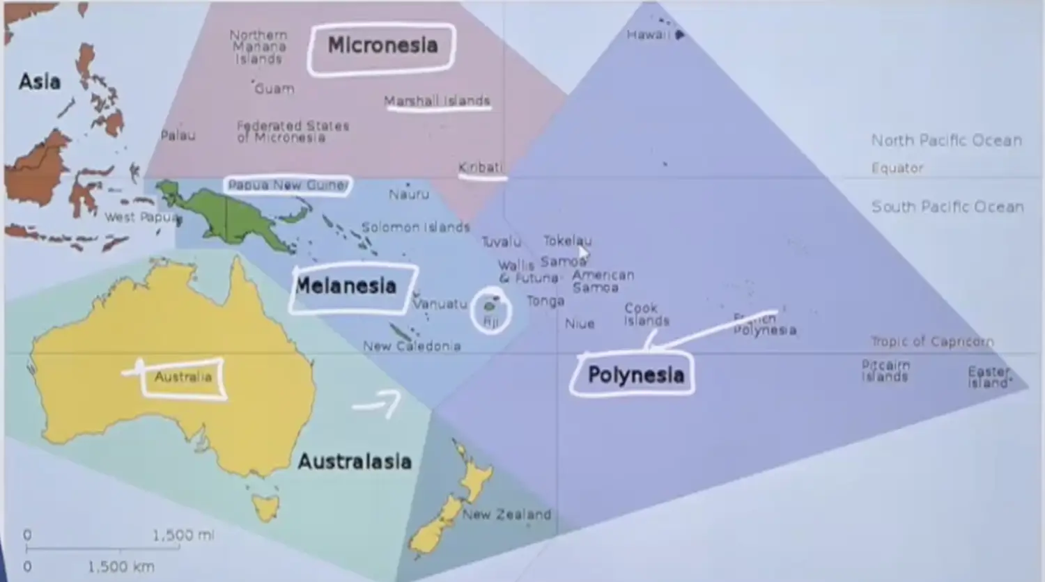
- Presence of a large number of Islands - Micronesia, Melanesia and Polynesia; Australasia
- Oceania = Micronesia + Melanesia + Polynesia + Australlia
- Micronesia - Kiribati and Marshall Islands
- Melanesia - Papua New Guniea Islands, Fiji Islands (due to Melanin Pigmentation)
- Polynesia - A large number of islands spread over a large area;
- Hawaii Island (50th State of USA)
- Eastern Island
- New Zealand
- Great Dividing Range - Australia
- Southern Alps - New Zealand
- Highest Peak - Mount Wilhelm in Papua New Gunea
- Deepest Point - Lake Eyre in Australia
Antarctica
- It is also called as White continent as 99% of it is covered in ice
- It is also called Terra Australis Incognita ie land south unknown
- There should be a land opposite to arctic. Hence it is called Anti Arctic
- Russians were first one to Land in Antarctica, then after 2 days Britain came
- Antarctic Treaty System, 1961 - Antarctica belongs to no one and is for peaceful purposes & scientific experiments only
- Only Few Species Survive Here : Emperor Penguins. For laying eggs they search Land, hatch eggs on foots
- During winter size of antractica allmost doubles
- Political Locations - Boundaries and Neighbours
- Physical - Mountains, Plains, Rivers, etc
- Economic Aspect - Transporation, Minerals
- Oceanic and Current related
India
Introduction
Indian Mapping
Neighbouring Countries
- Land Boundary (Ba Ch P A N M B A) → In Decreasing Order
- Bangladesh (4000 Kms)
- China (3500 Kms)
- Pakistan (3300 KMs)
- Nepal (1700 KMs)
- Myanmar (1650 Kms)
- Bhutan (700 Kms)
- Afghanistan - Wakhan Corridor
- Maritime Boundaries - Defined Boundary within 24 Nautical Miles, where any other country shares water
- Sri Lanka
- Maldives
- Indonesia - Andaman Nicobars Border With Sumatra
- Thailand
- Organsiation
- Maritime Borders - Coastguard (Para Military)
- Land Boundary - CAPF (Central Armed Police Force)
- BSF - Border Secutiy Force → Pakistan & Bangladesh
- CRPF - Central Reserved Police Force → Inland India
- ITBP - Indo Tibetan Border Police → China
- SSB - Shasastra Seema Bal
- CISF - Central Industrial Security Force → Urban & Industrial India
- Myanmar Border → Assam Rifles
- Difference between Paramilatry & CAPF
- CAPF is lead by their own officers and they come under home minitsry
- Para Military forces are lead by Army Officers & it comes under Defence Ministry
- Land Boundary (Ba Ch P A N M B A) → In Decreasing Order
Extreme Points of India
Points
- Southern Most Point
- Cape Comorin, Kanyakumari (on land)
- Indira Point (on water)
- Northern Most Point
- In Gilgit Baltistan → Indira Col near Sichen, in PoK
- Easternmost Point
- Kibithu (Arunachal Pradesh)
- Western Most Point
- Sir Creek (Kutch, Gujrat) && Ghuar Moti
States
- Northern Most - Jammu & Kashmir
- Southern Most - Andaman & Nicobar
- Eastern Most - Arunachal Pradesh
- Western Most - Gujarat
Other Points
Highest Point - Mt K2 or Mt Godwin Austin →
- Second Highest Peak in the World
- Most Dangerous Peak in the World
- Difficult to Climb than Mt Everest
- More people have gone on space than who have climbed K2
- 1/3 of people who tried climbing have died
Highest Point in Indian Occupation - Kanchenjunga Peak
Lowest Point in India Occupation - Kuttanad, Kerela
Famous for Below Sea Rice Farming. Known for cultivating Rice & Fish
- Southern Most Point
States and Union Territories (UTs)
28 states in India and 8 Union Territories (UTs)
- UT of India
- Jammu & Kashmir
- Ladakh
- Chandigarh
- Common Capital of Haryana and Punjab
- Delhi
- NCR - National Capital Region
- NCR has no Legal Existence
- Haryana, UP, Rajasthan
- NCT - National Capital Territory
- Delhi NCT is UT. NCT comes under Delhi Govt
- NCR - National Capital Region
- Daman & Diu & Dadra & Nagar Haveli - They were under Potuguese
- Puducherry
- Culturally & Historically Different
- Spread Across 3 States
- Spread Across 4 Points
- 2 in Tamil Nadu - Karaikal & Puducherry
- 1 AP - Yanam
- 1 Kerala - Mahe
- Lakshwadeep
- Andaman & Nicobar
- States of India
Indian Map
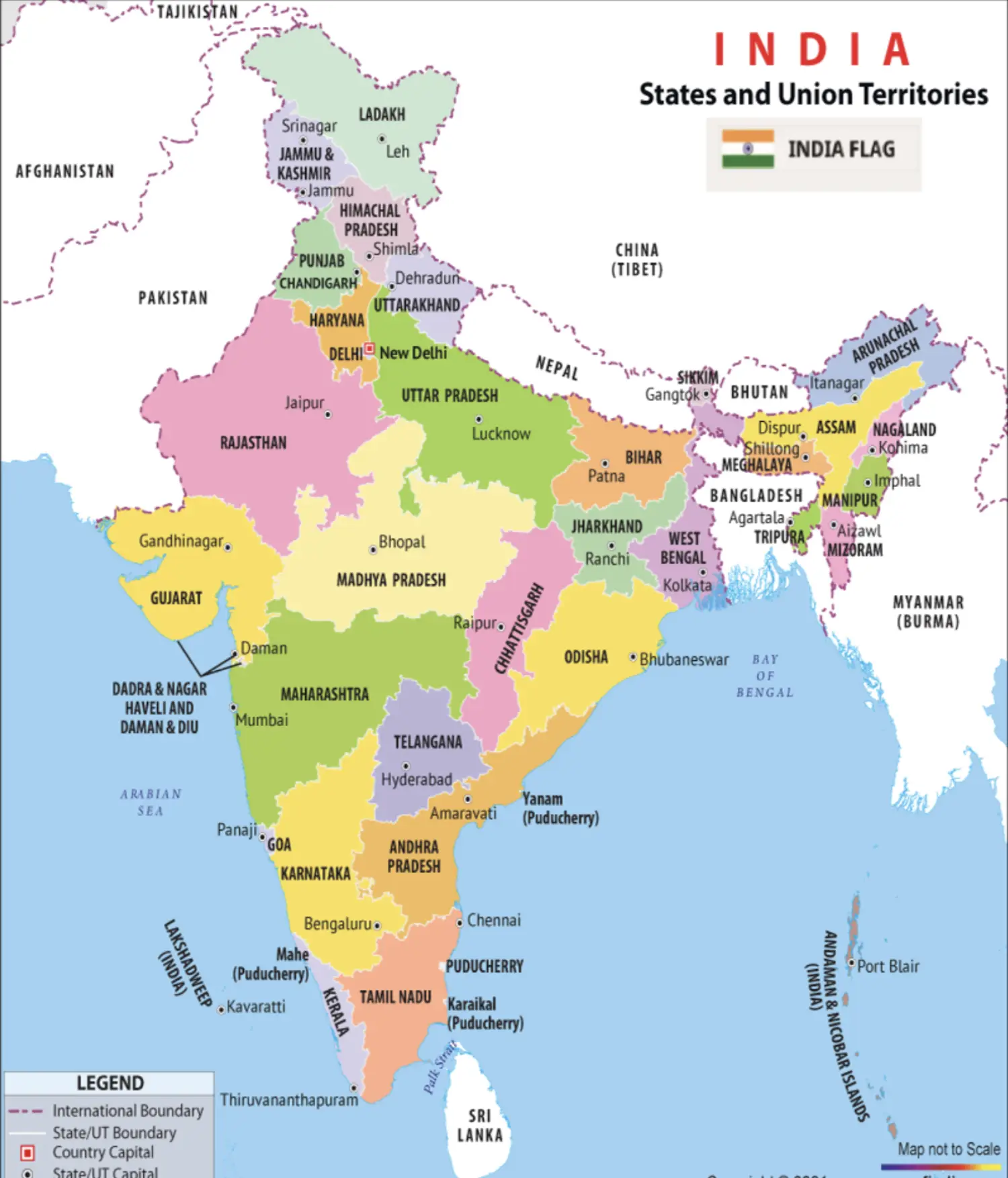
States
- Northernmost (6)
- j&k (UT)
- Ladakh (UT)
- HP
- Uttarakhand
- Punjab
- Haryana
- Western (4)
- Gujarat
- Rajasthan
- MP
- Mah
- Southern (6)
- Goa
- Karnataka
- Telangana
- AP
- TN
- Kerala
- Eastern (6)
- UP
- Bihar
- CG
- Jharkhand
- Orissa
- West Bengal
- North East (8)
- Sikkim
- Assam
- AP
- Nagaland
- Manipur
- Mizoram
- Tripura
- Meghalaya
- Northernmost (6)
Borders of Indian States with Other States (Visualise, Not Memorise)
Border states of Chattisgarh - Andhra Pradesh, Telangana, Odisha, Jharkhand, Madhya Pradesh, Maharashtra, Uttar Pradesh. (Not Bihar)
Intra State Facts
North
No direct passage between Rajasthan and Maharashtra
Ladakh is connected to Himachal Pradesh (not Punjab)
Punjab joins Jammu & Kashmir via Pathankot
Punjab has direct connection with Rajasthan
Punjab and Rajasthan are connected directly and have an international border with Pakistan
There is Indira Gandhi canal between Punjab & Rajasthan
Haryana has no international border and is not connected to Uttrakhand directly
Boundary between Haryana and UP is Yamuna River
Imp : Haryana and Uttarakhand have no boundaries
Imp : Himachal & UP are Connected
Paonta Sahib
is an important pilgrimage site for Sikhs
the place where yamuna river enters Himachal Pradesh here
South
- Kerala has boundaries with Tamil Nadu and Karnataka
- Tamil Nadu has boundaries with Kerela, Karnataka and Andhra Pradesh
- There is no border between Telangana and Odisha
- Karnataka has boundary with allmost all southern states
- There is a direct border between Andhra Pradesh and Chattisgarh
- There is NO border between Telangana & Orissa
- AP has border with Puducherry throug Yanam
East
There is a border between Uttar Pradesh and Chattisgarh
But No Border between MP & Jharkhand
But No Border between MP & Bihar
No border between Chattisgarh and Bihar
Northeast
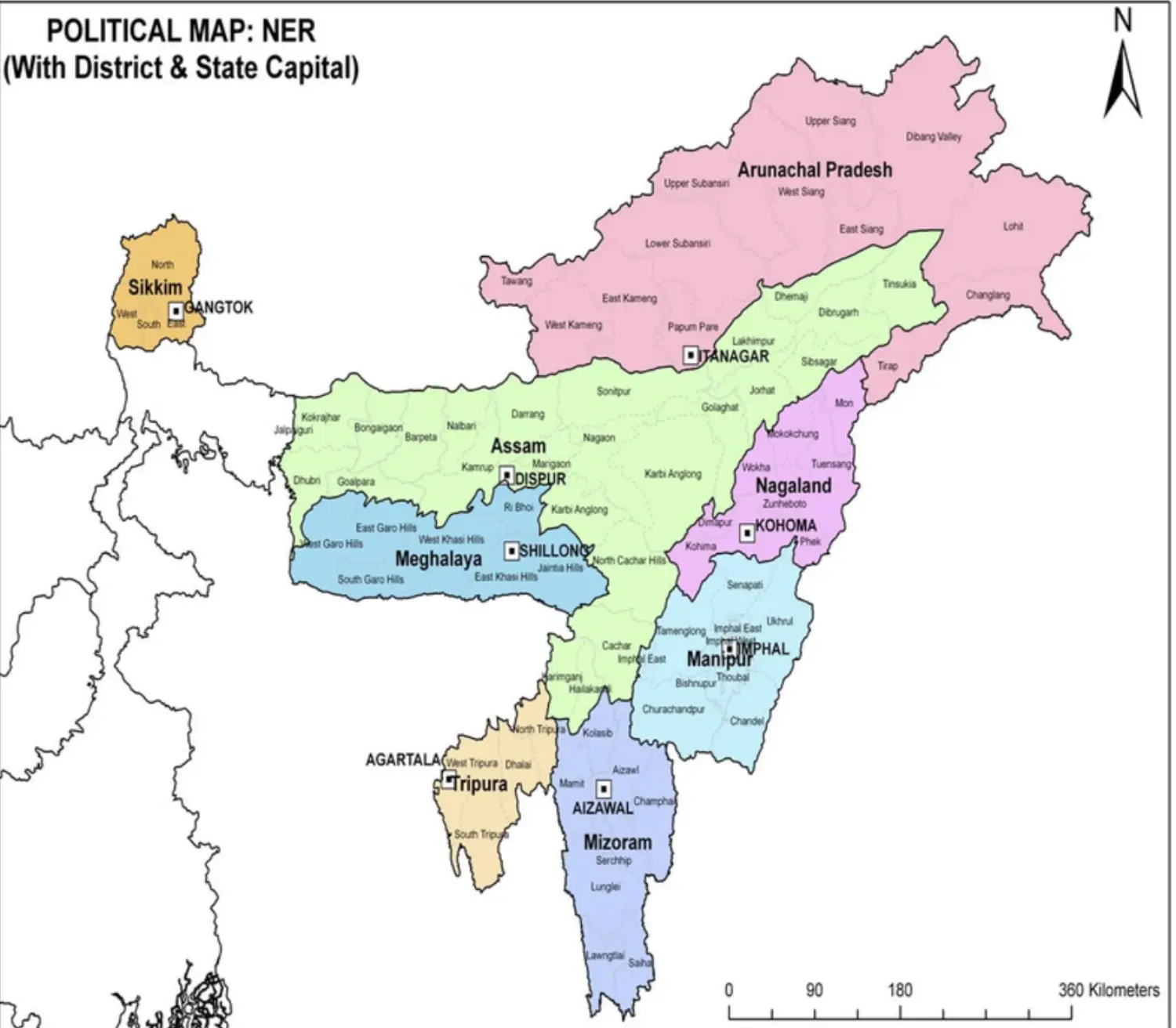
- Sikkim has border only with West Bengal
- To Go to North East, West Bengal is a must. Here it is Siliguri Corridor, which is called as the Chicken Neck of Indian Physiography
- Assam has a border with Arunachal Pradesh, Nagaland, Manipur, Mizoram, Tripura and Meghalaya
- Remeber States of North East
- Central is Assam - Plain Area
- North Part - Brahmputra Plains
- Souther Part - Barak Plain
- North of Assam - Arunachal Pradesh
- South of Arunachal Pradesh - Naga Hill - Naga Land
- South of Naga Land - Manipur Hills - Manipur
- South of Manipur - Mizo Hills - Mizoram
- Beside Mizoram - Triputa Hills - Tripura
- North of Tripura is Meghalaya
- Megahalaya has border only with Assam
State which has border with only one state
- Meghalaya
- Sikkim
States having international borders
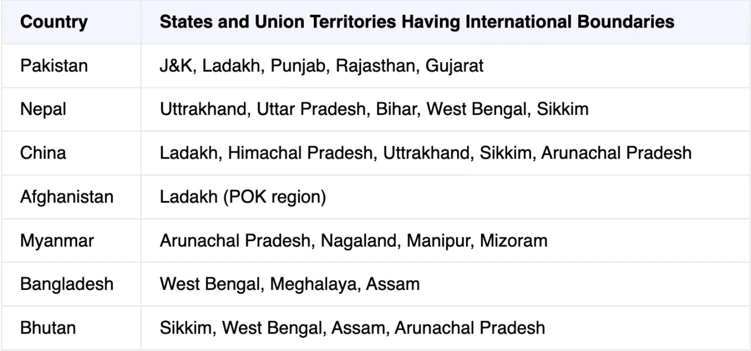
Capitals of all the states
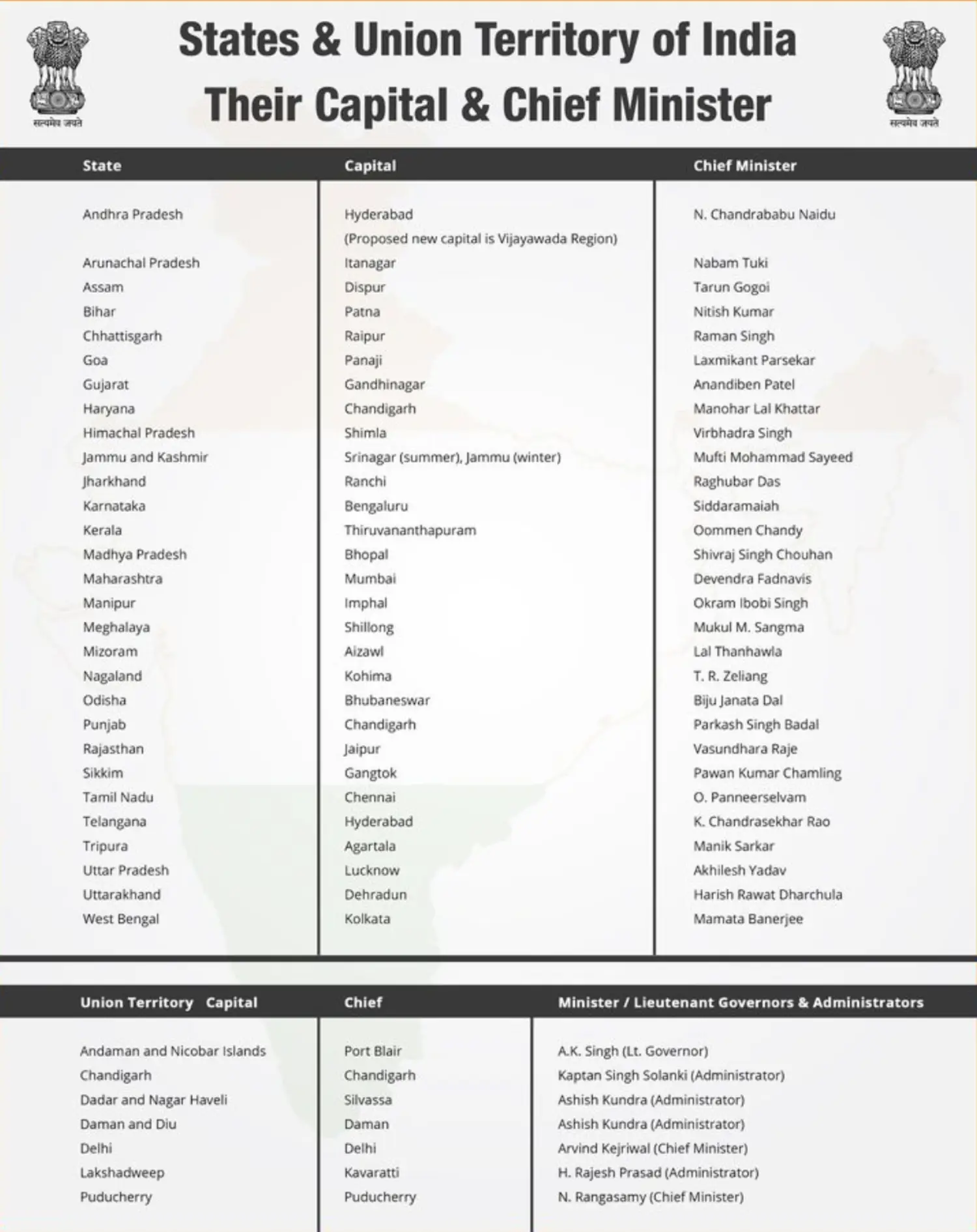
- UT of India
Mountain, Plateaus, Island, Rivers
Environment - Wetlands, NP, TR, BR, Ramsar Sites, etc
Transportation, resources, etc
Current related locations from India's perspective
Tribes of India through Map, etc
- Asian Continent - Political
- Regions
- West Asia/Middle East
- Central Asia
- South Asia
- South-East Asia
- Oceans
- The Arctic Ocean, Caspian Sea - Boundary between Asia and Europe
- Black Sea, Mediterranean Sea; the Red Sea, Gulf of Aden, Arabian Sea, Persian Gulf, Gulf of Oman; Bay of Bengal; Andaman Sea - on the eastern side of the Andaman Islands, Gulf of Thailand; South and the East China Sea, Yellow Sea, Sea of Japan and East Sea, Bering Sea
- Regions
- West Asia
- Not in West Asia - Georgia, Armenia and Azerbaijan
- Countries - Turkey and Iran; Yemen and Oman; Saudi Arabia,
- Cyprus - It is a member of the EU; geographically located on the continental shelf of Asia; in the UN it sits in the Asia-pacific group
- Ankara is the capital of Turkey; Turkey is both in Europe and Asia
- The Aegean Sea and Sea of Marmara (connected with the Black Sea) - separate European Turkey and Asian Turkey; Istanbul (earlier Constantinople - silk trade used to pass through) is in European Turkey; the largest city of entire Europe
- Iran - capital is Tehran; waterbodies - Caspian, Sea, Gulf of Oman, Arabian Sea, Persian Gulf
- Persian Gulf - Iran on North; Iraq, Kuwait, Saudi Arabia (also access to the Red Sea),
- No country in West Asia is landlocked
- UAE (Capital - Abu Dhabi) is between Saudi Arabia and Oman (Muscat)
- Houthi rebels in Yemen and the civil war is going on
- Qatar (Doha) - It is a peninsula; with only a border with Saudi Arabia
- Bahrain - It is an island
- Riyadh is in the middle of Saudi Arabia; Mecca and Medina are in Saudi Arabia; Monarchy still prevails there
- The capitals of these countries are important
- Oman has a coast in the Persian Gulf
- Gulf of Oman - Oman and UAE
- Gulf of Aden - Yemen, Somalia, Djiboutii
- Red Sea - Yemen, Saudi Arabia, Israel, Egypt, Sudan, Eritrea, Jordan
- Gulf of Suez and Gulf of Aqaba (Jordan, Saudi Arabia, Israel, Egypt - two ports Aqaba - Jordon; Elat - Israel)
- Jordan (Amman) - has a cost in the Gulf of Aqaba; the Jordon River marks the border between Jordan and Israel; It enters and drains into the dead sea (the lowest point on the continent of the earth)
- Israel - the land of Jews; Jerusalem is capital
- Palestine - West Bank (west bank of Jordon river) and Gaza
- Lebanon (Beirut is the capital)
- Syria - Damascus is the capital of Syria
- Golan Heights - occupied by Israel in 1967 during 6 days of the war; junction of Syria, Jordan, Israel and Lebanon
- Shia countries - Iran, Iraq and Bahrain and Lebanon; ruler of Syria ie Assad but people are Sunni
- Sunni - Saudi Arabia
- Kurdistan - Border area of Turkey, Iraq and Syria; tribal people who live here are Kurds
- GCC - Kuwait, Saudi Arabia, Bahrain, Qatar, UAE and Oman are part of it; Iran and Iraq are not part of it
Central Asia: (3:14 PM)
- 5 Central Asian Countries - Kazakstan, Uzbekistan, Tajikistan, Kyrgyzstan, Turkmenistan
- Afghanistan is not traditionally part of Central Asia
- India has a border with Afghanistan in Wakhan Corridor
- All are landlocked countries except Turkmenistan and Kazakstan
- Uzbekistan is doubly landlocked - surrounded by all landlocked country
- Capitals:
- Kazakstan - Noor Sultan
- Kyrgyzstan - Bishkek (Pamir Knot, Bisket Declaration for Snowleopard Conservation)
- Uzbekistan - Tashkent
- Tajikistan - Dushanbe
- Turkmenistan - Ashgabat
South Asia: (3:34 PM)
- They are called SAARC Countries
- Afghanistan, Pakistan, India, Nepal, Bhutan, Bangladesh, Srilanka, Maldives
- Try to refer to the capitals of these countries
South-East Asia: (3:37 PM)
- It has 10 countries that are members of the ASEAN
- 5 countries for the mainland - Myanmar, Thailand (maritime boundary with India in the Andaman Sea), Vietnam, Laos, Cambodia; also known as Indo-China
- 5 Island countries - Malaysia, Singapore, Indonesia, Brunei, Philippines
- This region has maximum Archipelago due to Ocean Ocean Convergent boundaries
- Coco Islands - Myanmar has a maritime boundary with India
- Thailand - Bangkok (Bangkok Declaration - ASEAN was established through this declaration)
- Laos - Vientiane is the capital
- Cambodia - is famous for its Angkorvat Temple; Phon Penh is the capital
- Vietnam - Hanoi is the capital
- Malaysia - Kuala Lumpur is the capital; Islamic majority country
- Singapore - Island; is the world's busiest port
- Indonesia - Sumatra, Java; Jakarta is the capital and is in Java; now the capital is being shifted; It has the highest Islamic population in the world
- Brunie - Bandar Seri Begawan is the capital
- The Philippines - Manila is the capital; it has 3 important regions ie Luzon, Visayas and Mindanao
- Note: East Timor is part of Asia but not part of ASEAN
Topics for the next class: Continuation of World Mapping, etc