2 Climatology - Study of Climate of India
Indian Geography
Monsoon
Introduction
Introduction
- Indian Climate is described as Tropical Monsoon Climate
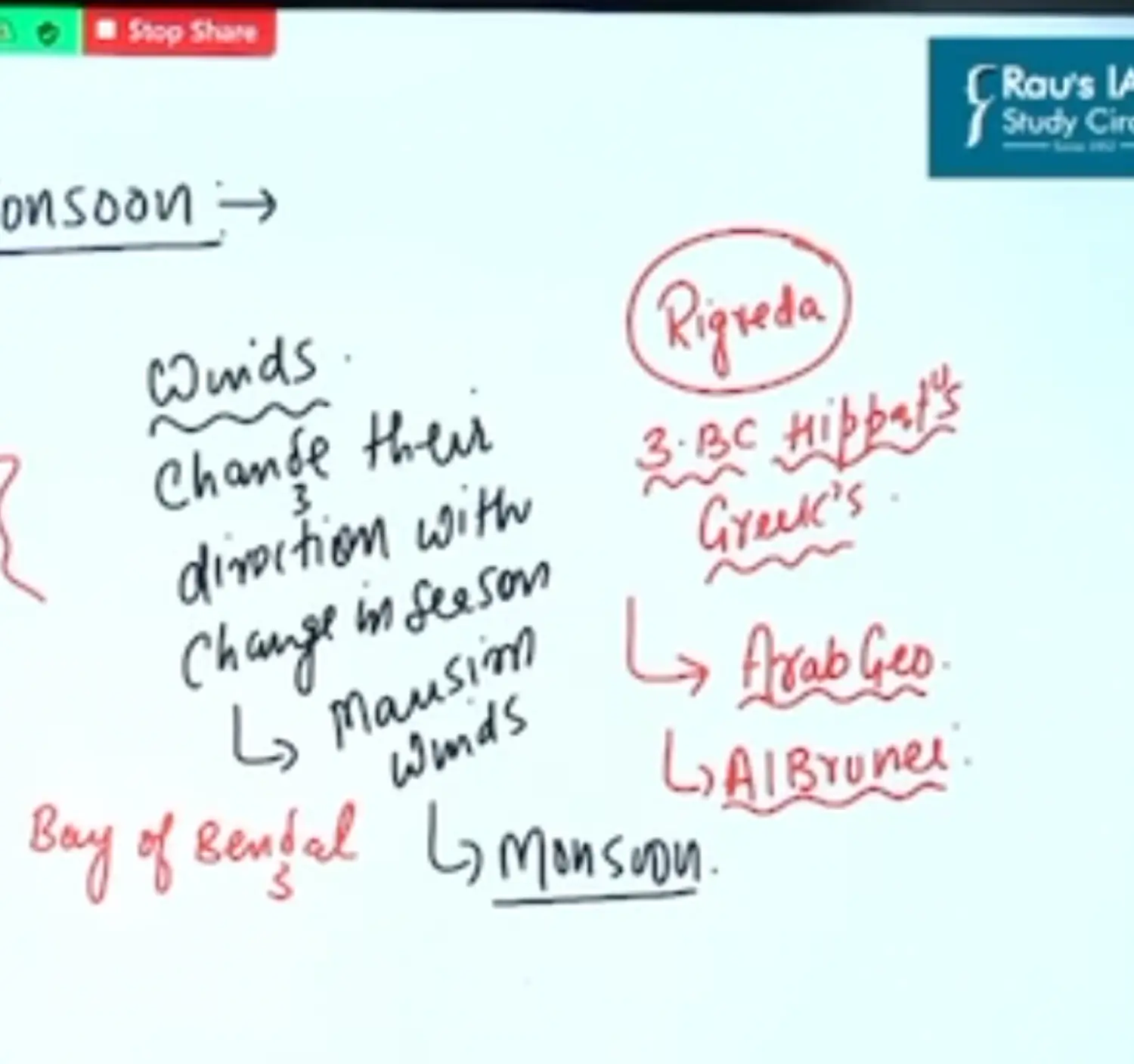
- Monsoon is derived from Arabic Word Mausim meaning Season
- Rig Veda mentions Monsoon
- IN 3rd BC Hippatus from Greek Mentions Monsoon
- Arab Geo coined it for the first time, Monsoon has been documented in Rig Veda also
- Alberuni brought it to Limelight. Experience of Gujarat Coast
- Monsoon is a Seasonal Wind, Periodic Winds
- It Indicates Seasonal Changes, in the distribution and pattern of Rainfall, Temperature, Atmospheric Pressure and direction of winds on the basis of seasonal distribution of above 4 Parameters
- On the Basis of above 4 parameters Climate of India is divided into the following
- Winter - Cold and Dry - Dec Jan Feb
- Summer - Hot & Dry - Apr & May
- SW Monsoon - Hot & Humid - June July Aug Sep
- Retreating Monsoon / October Heat - Oct Nov
- In Spite of the fact that Great Plains of India are located in Subtropical Zones but still Indian Climate is called as Tropical Indicating it is Hot and Humid Conditions with Seasonal Rainfall
- Monsoons are Modification of Trade Winds. Hence also called as Cross Equatorial Westerlies
Tropicality of India has been Contributed by the following Physiographic Factors
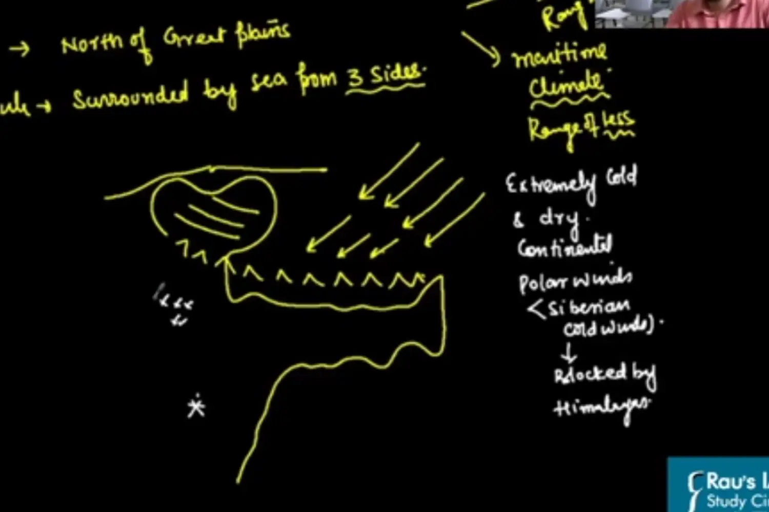
Himalayan Mountains - Which Lie to the North of Great Plains
Indian Peninsula surrounded by Sea from all three sides
Range of Temp = Continentality = More as we move away from Coast
In Winter Season Extremely Cold Polar winds are prevented by the Himalayan Mountain Ranges to flow in the Great Plains of India
Here Siberian Extremely Cold Winds are blocked by Himalayas
Factors Controlling Indian Climate
- Latitude
- Altitude
- Topography
- Distance from the Sea
Characteristics of Monsoonal Climate
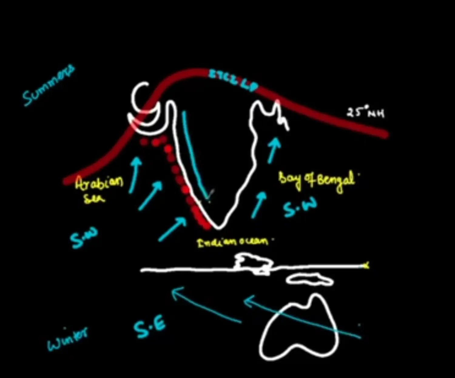
In Summers
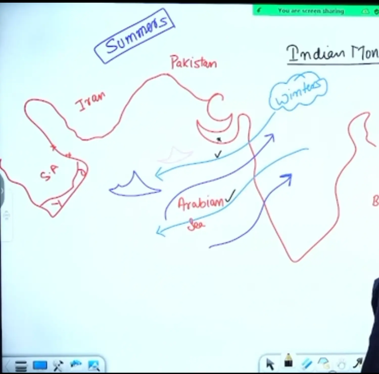
South East Trade Winds Become South West Trade Winds
It is then divided into two Branches by Indian Peninsula
Summers
Western Coast - Wet
Eastern Coast - Dry
Summers Case
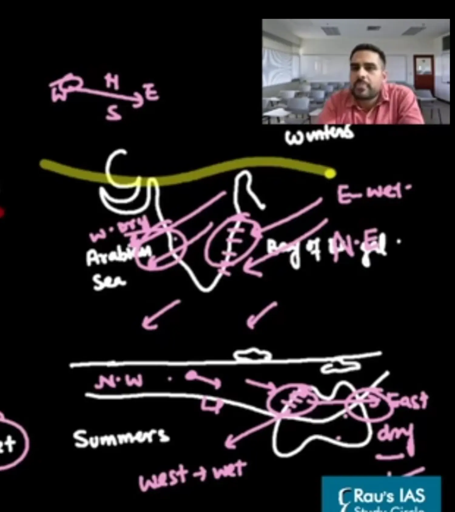
In Winters
Eastern Coast - Wet
Western Coast - Dry
Mechanism and Origin of Indian Monsoon
Theories on Monsoon
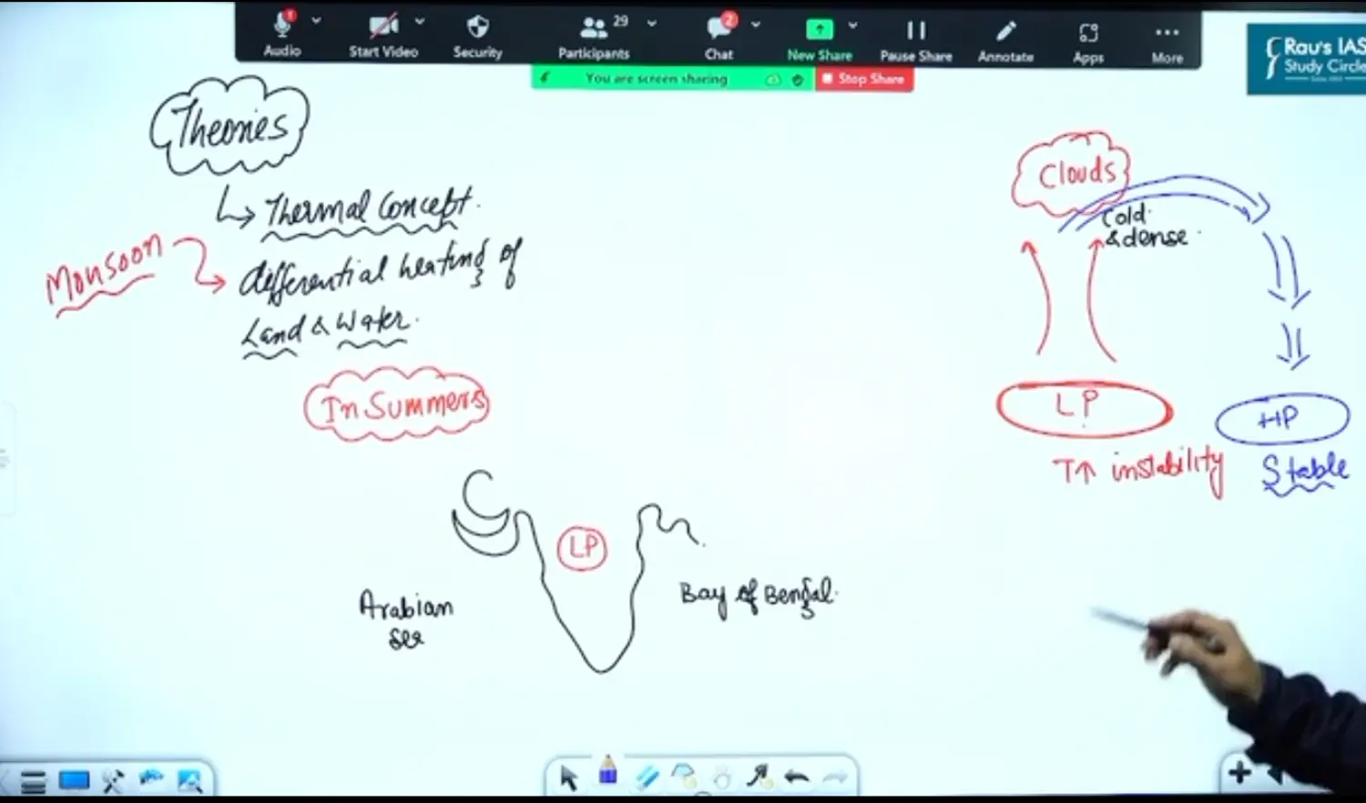
Theory 1: Thermal Concept of Differential Heating of Land and Water
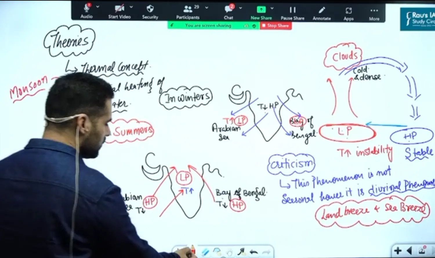
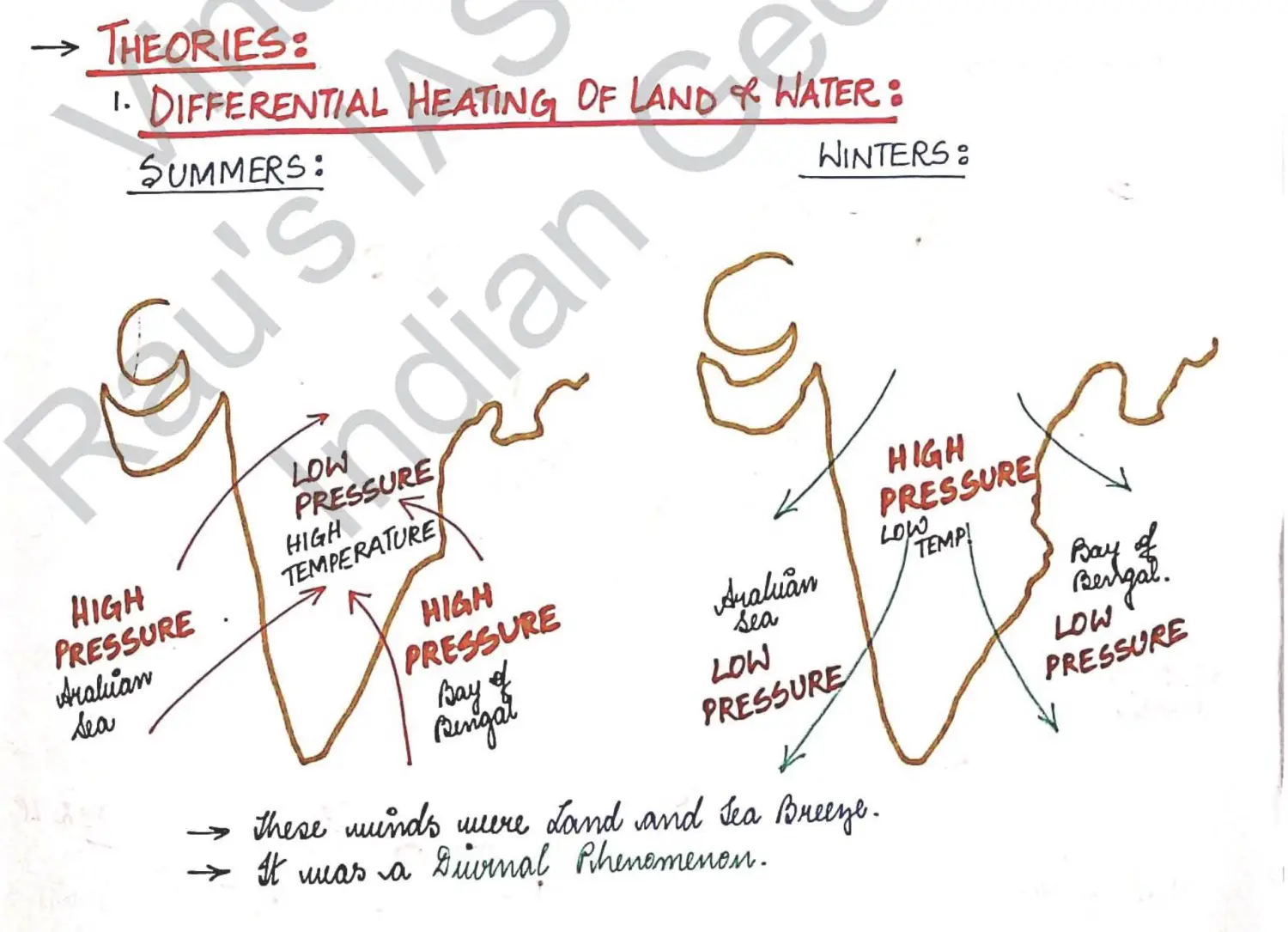
Critic 2 - It does not explain winter rainfall in north west of India or Northern Part of India
Theory 2: Explained by ITCZ Theory
- Introduction
ITCZ - Intertropical Convergence Zone
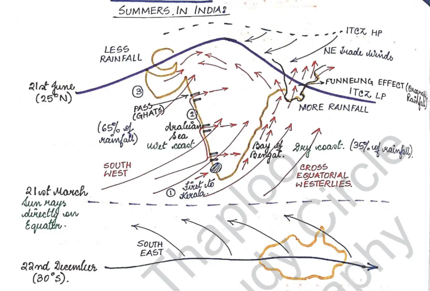
Summer Part
ITCZ Shifts upto Ganga Plains
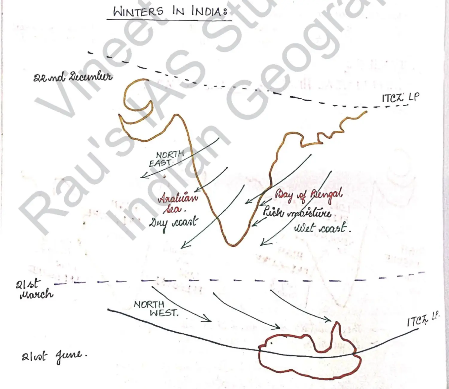
Winter Part
Summer
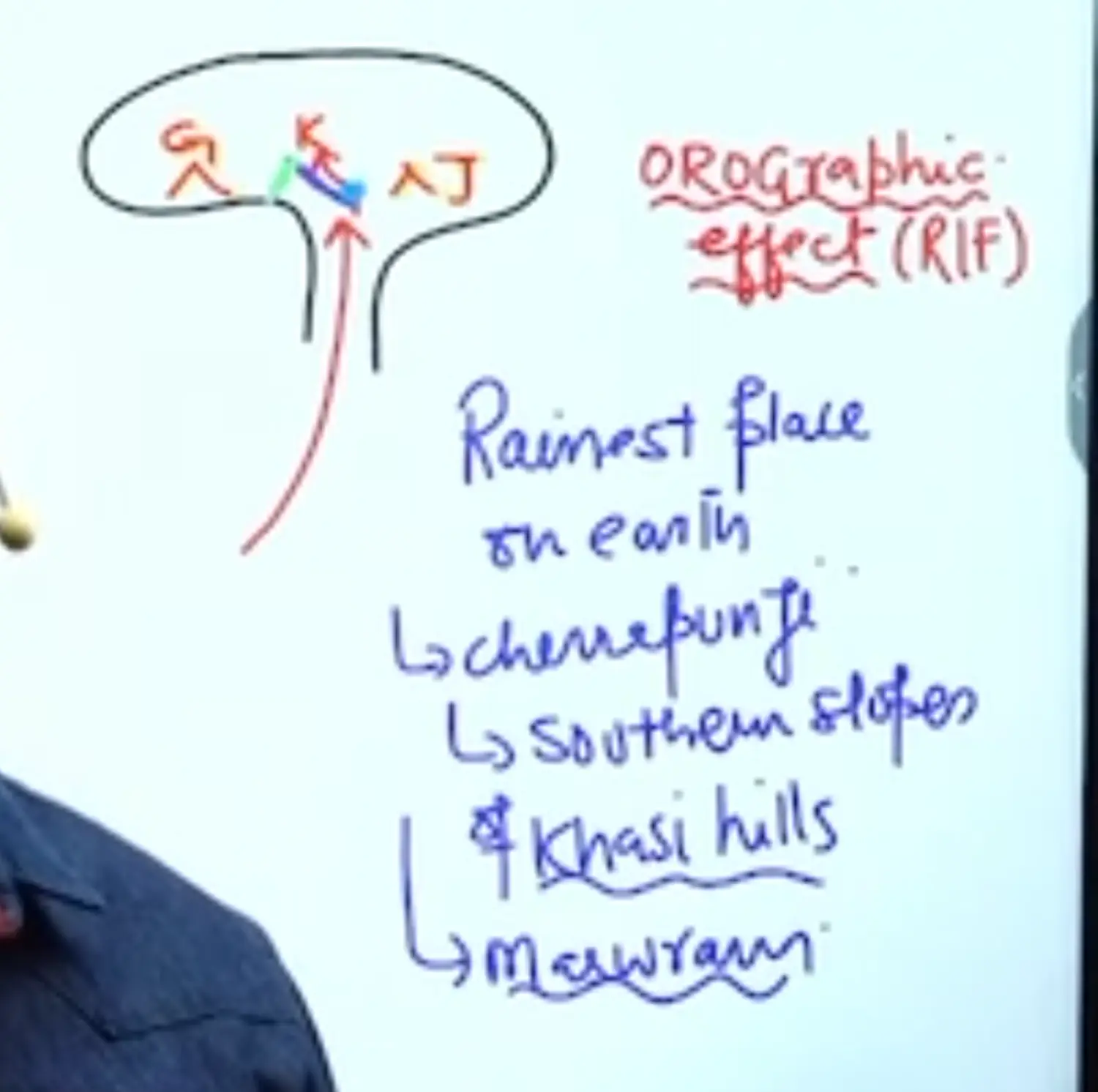
Funneling Effect of Garo Khasi Jaintia
Orographic Effect
Cherrapunji is in SOuthern Slopes of Khasi Hills
Khasi is Surrounded by Garo & Jaintia
Rain is caused by Orographic Effect
Prelims Question Pointer - Very Important
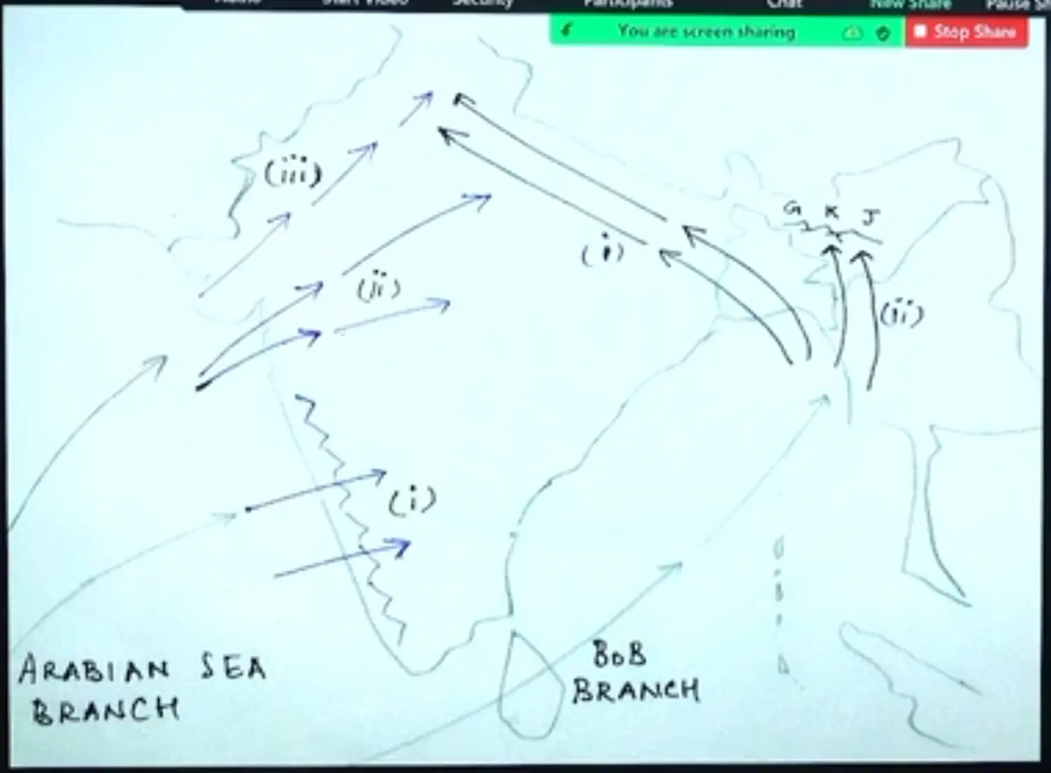
- Arabian Sea Rainfall Decreases from West to East
- Bay of Bengal Branch Decreases from East to West
- Over All Rainfall decreases from South to North
- They come together in Centre and Rise Along Himalayas and can sometimes result in cloud bursts
Branching of Monsoon - In Handwritten Notes
Winter
Introduction - Add Handwritten Diagrams
- Tamil Nadu and Andhra get Rainfall in Winter Monsoon
- Summer Monsoon for Australia is Winter Monsoon for India
Rice in South in Winters
TN & Andhra - Cultivate Generally in Winters but now they cultivate it in Summers as Well
Rice Needs Greater than 20 Degree C Plus and 150 CM Rainfall
Toh Coast hai toh Winter Main 20 Degree hi Rehta Hai, Naam ka Winter Hain
Rain TN & Andhra main Retreating Monsoon de deta hai !
Winter Main Western Coast Main Baarish Kaise Aayi
Monex Expedition on Monsoon
Joint Experiment of India and USSR ( Present Russia) under Supervision of WMO ( World Meteorological Organisation)
WMO is a Part of Economic and Social Council
From India Professor Koteshwaramma & Other prof was M Yun →
They Propounded that Tibetan Plateau Intensified Indian Monsoon → Cuz they Generate Tropical Easterly Jet Stream which is a Seasonal (Temp) Jet Stream
It is only Formed in Summers due to Heating of Tibetan Plateau → This Jet is also called Koteswaram Jet
Explanatory Diagram
Diagram 1
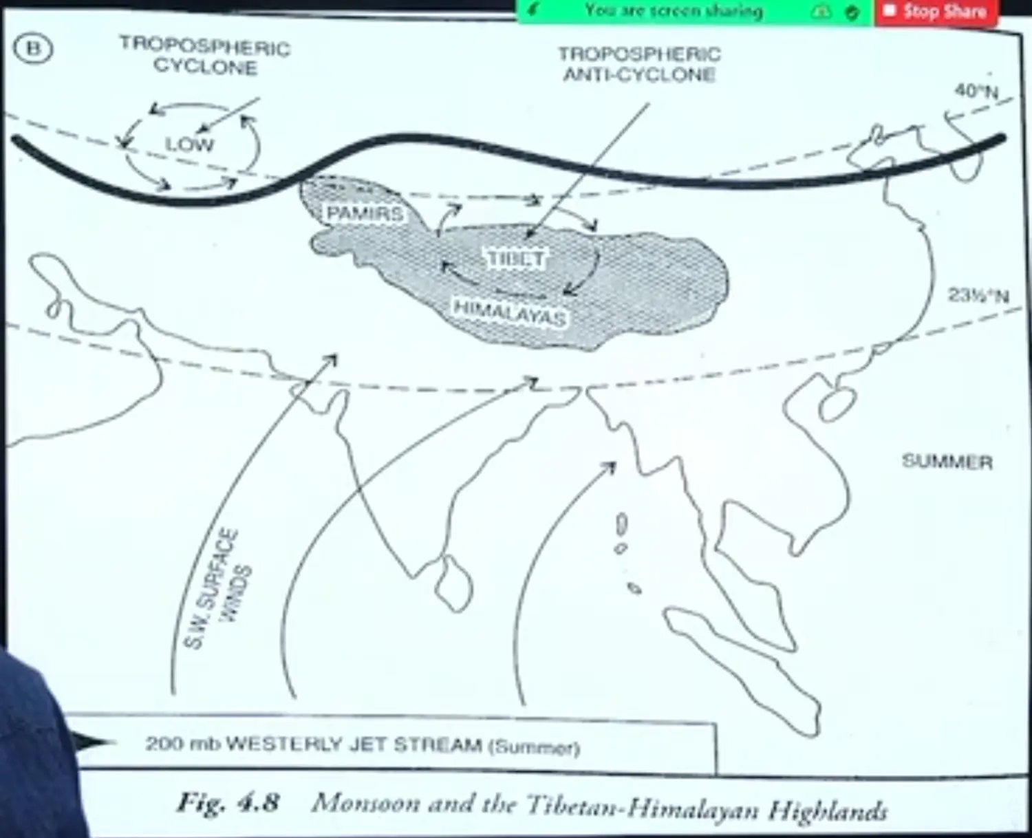
Diagram 2 : Cross Sectional Diagram of Meridional or Hadley Cell
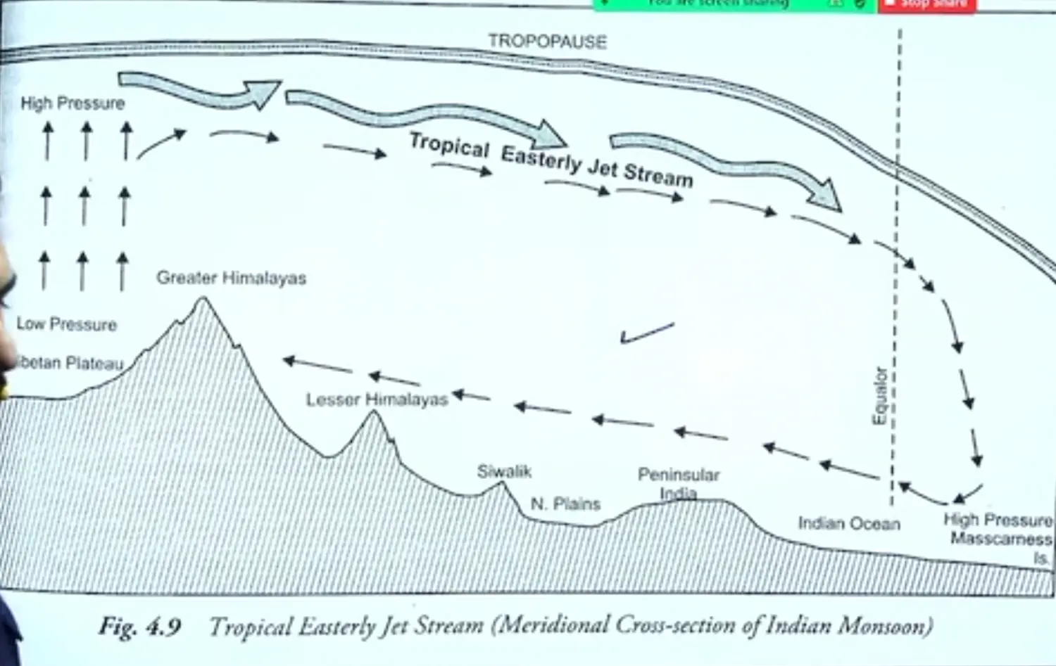
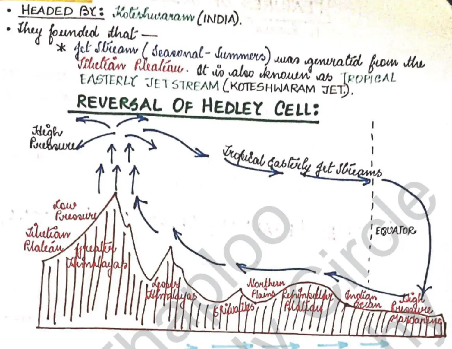
Diagram 3
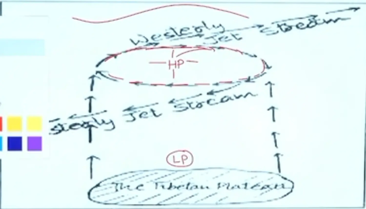
Diagram 4
- Introduction
Allied Concepts with Monsoon
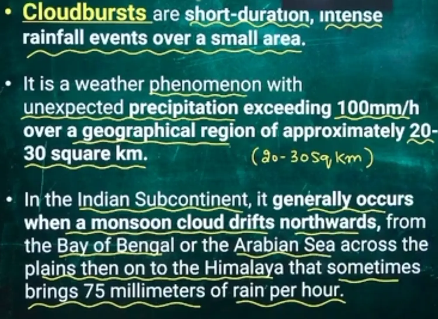
Cloud Burst Mechanism
- When Cloud is Super Saturated - When Relative Humidity goes more than 100%
- In Himachal It is locally called Pangola
- Pangola is accompanied by Thundering and Lightening
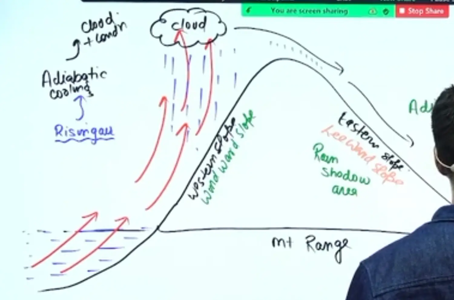
Concept of Windward and Leeward Rainfall
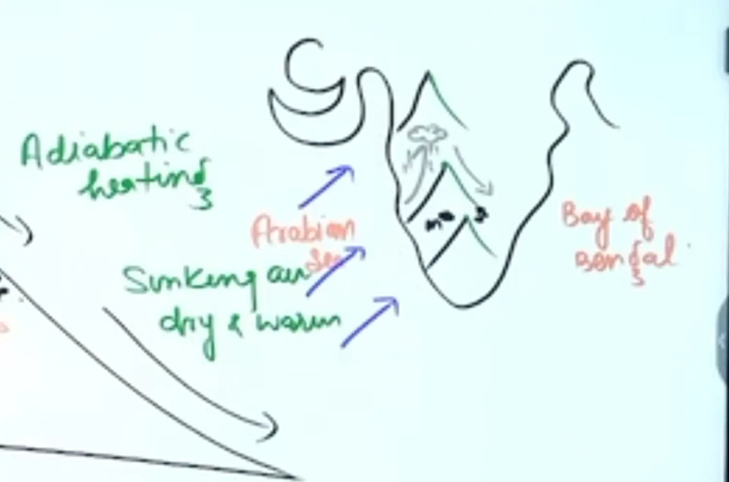
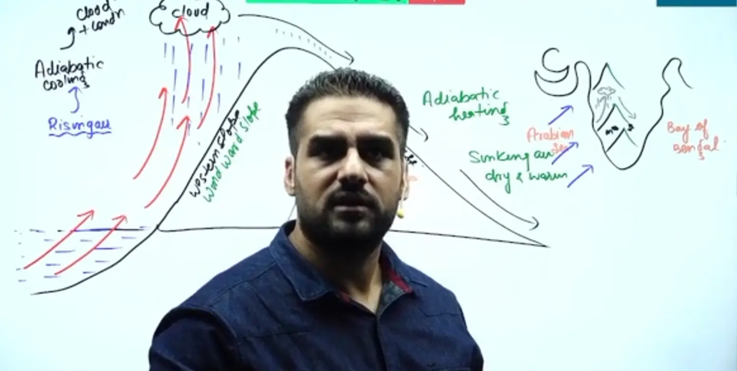
Occurrence of Cloud Bursts
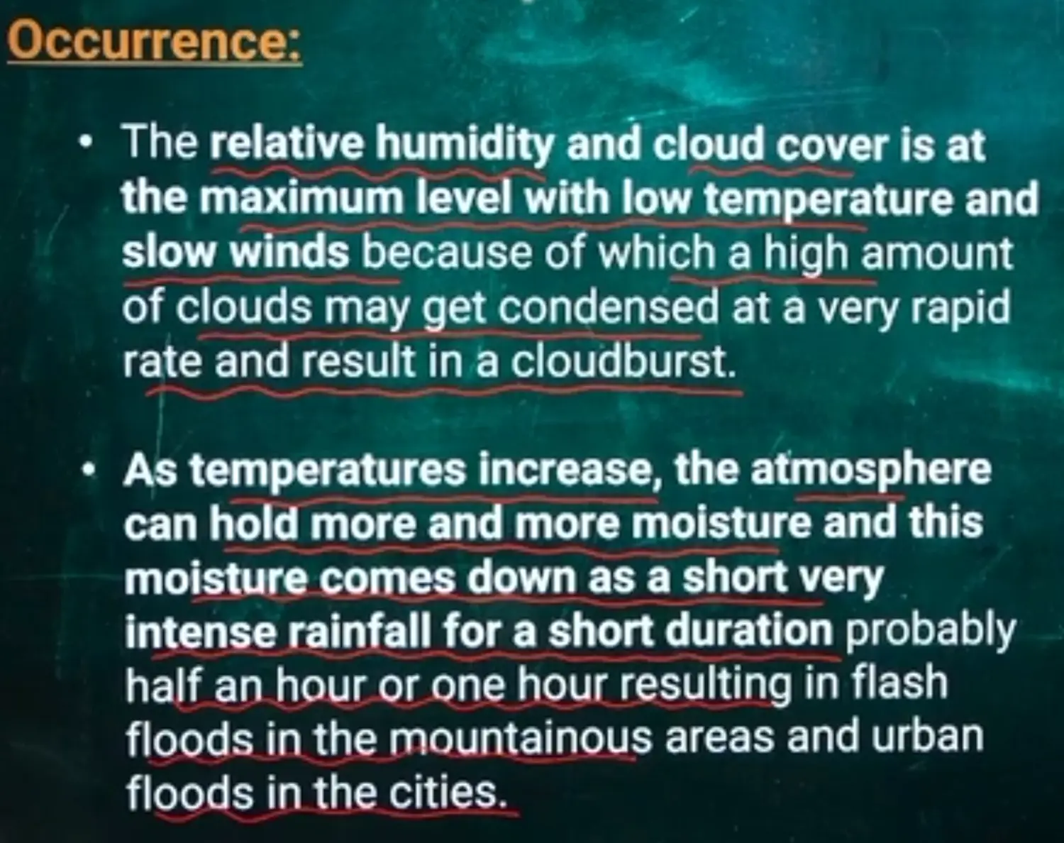
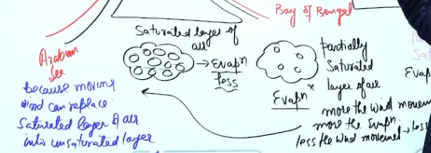
Slow Wind Movement Needed Because - If Wind Movement will be more, Rate of Evaporation will be more
Condensation Tabhi Hogi, Jab Air Mass Saturated Hoti Hai Puri 100% → Isme Less Evapouration Hoga
Partially Saturated Layer of Air main → More Evapouration Hoga, Kyunki Ye Abhi aur Paani le Sakta Hai
Evapouration hoga toh Condensation Nahin Hoga, Condensation Hoga toh Evapouration Nahin Hoga
Dushman Hain Dono
Evapouration is Directly Proportional to Evapouration - Because Moving Wind can replace saturated layer of Air into Unsaturated Layer of Air
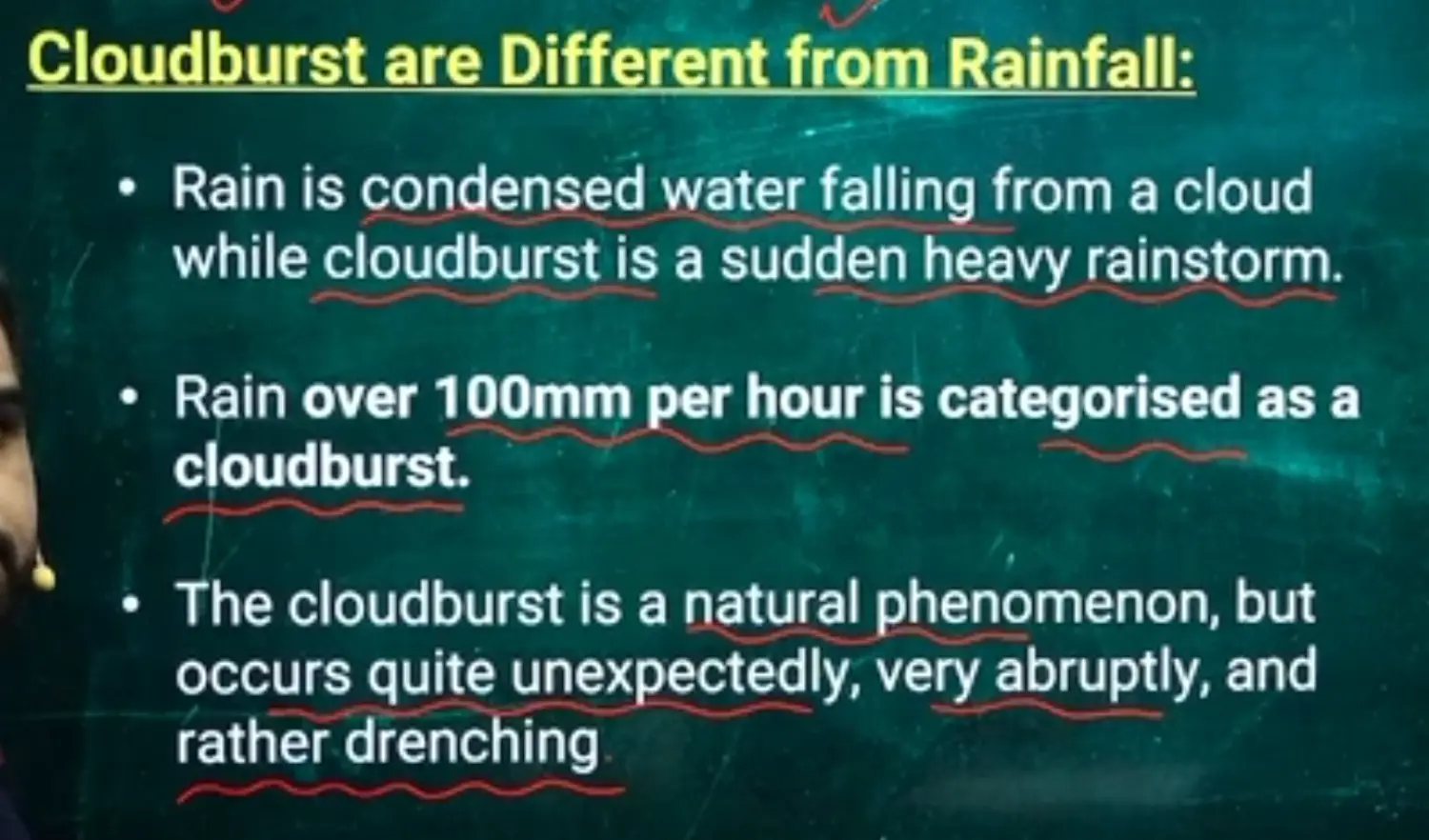
How is Cloudburst different from Rainfall
Types of Monsoon
- Summer Monsoon (also called South West Monsoon)
- Arabian Sea Branch
- Bay of Bengal Branch
- Winter Monsoon (also called Retreating Monsoon)
Air Mass Concept of Monsoon
Conditions Required for Formation of an Air Mass
Air Mass Becomes Stationary → When Kinetic Energy of Wind becomes Equal to Frictional Force of Wind the Air Mass becomes Stationary
Isotrophic Surface on Land or Ocean
Hill or Mountainous Topography → Rugged Surface should not be Present → Rolling Plains are suitable for creation of Air Mass
Because of Hills or Mountains, The Hills tend to deform the Creation Air Mass
Upper Atmospheric and Surface Conditions
In the Upper Atmosphere - Cyclonic Conditions - LP
Surface - Anticyclonic Conditions - HP
Length and Height of Air Mass from Physical Geography
Tropical Maritime Monsoonal Air Masses are developed on Bay of Bengal and Arabian Sea
Details of Indian Monsoon
Basics of Monsoon
- Monsoon is a Secondary Circulation, Produced by Thermodynamic Modification with Trade Winds over Indian Sub Continent due to apparent shifting of sun across the seasons.
- It is also defined as the Seasonal Reversal of Wind Systems
- it is characterised by Rhythm of Seasons i.e Summer and Winter ; Dry and Wet Spell of Rainfall and Summer Concentration of Rainfall (Max Rainfall in Summers)
Features of Indian Monsoon
- If Deflection//Reversal of Wind is more than 120 degree out of Max 180 degree is called Monsoon
- If Deflection of Wind is less than 120 degree out of 180 degree is called Pseudo Monsoon
- In Month of July Increase in Frequency of Wind by 40% Occurs because of Increased Pressure Gradient
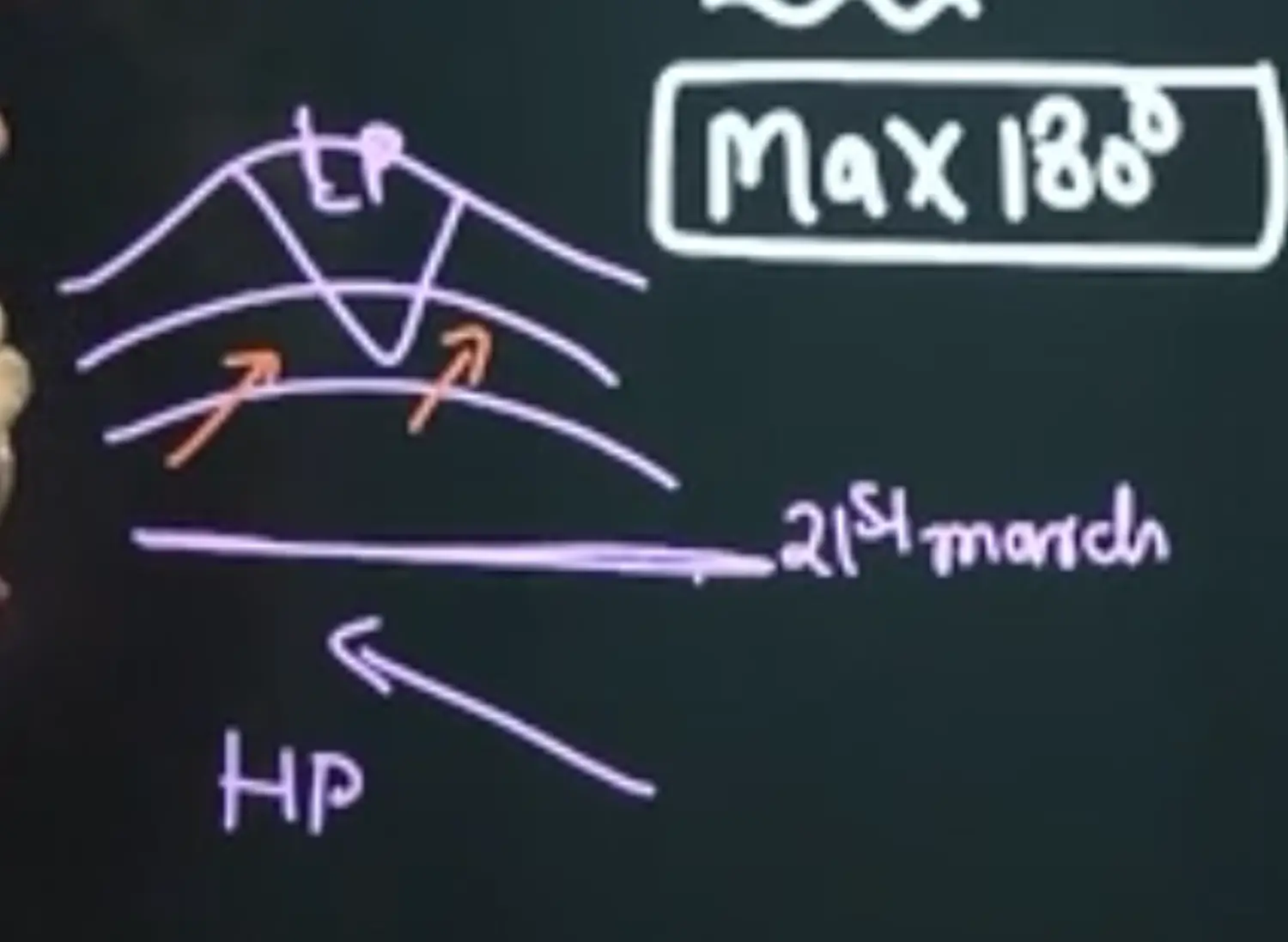
- In July Acceleration of Wind is by 3 cm per square min ( 3 cm/min2)
- Rhythm of Season and Reversal of Hadley Cell
Earlier Hadley cell which was from Equator to Tropic is Now from Tropic to Equator
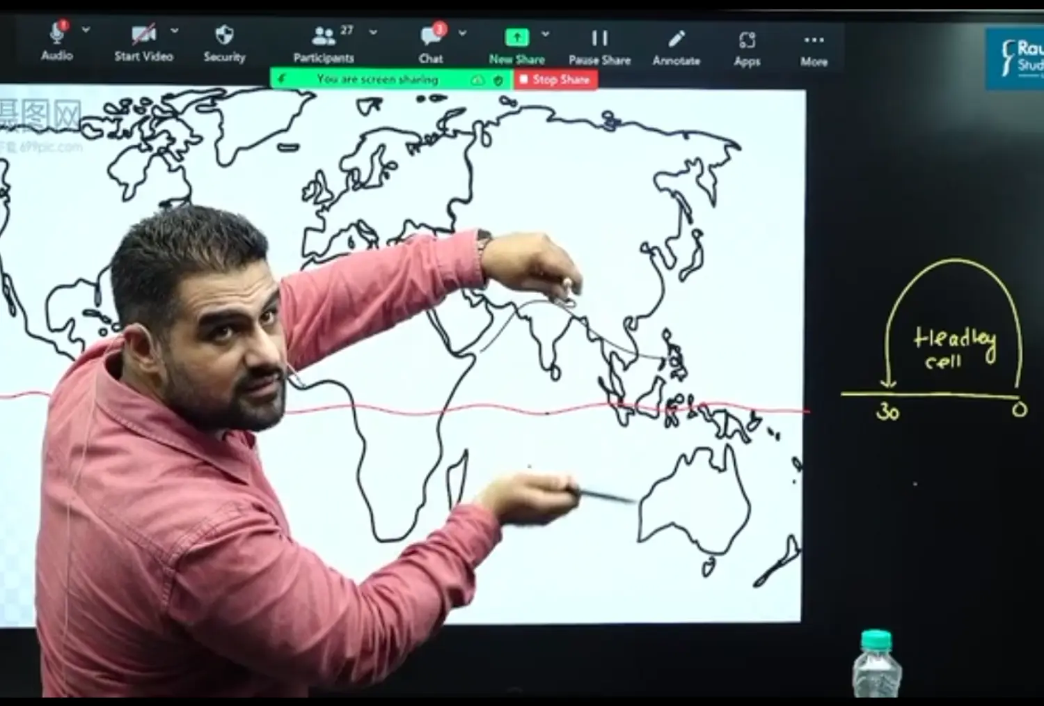
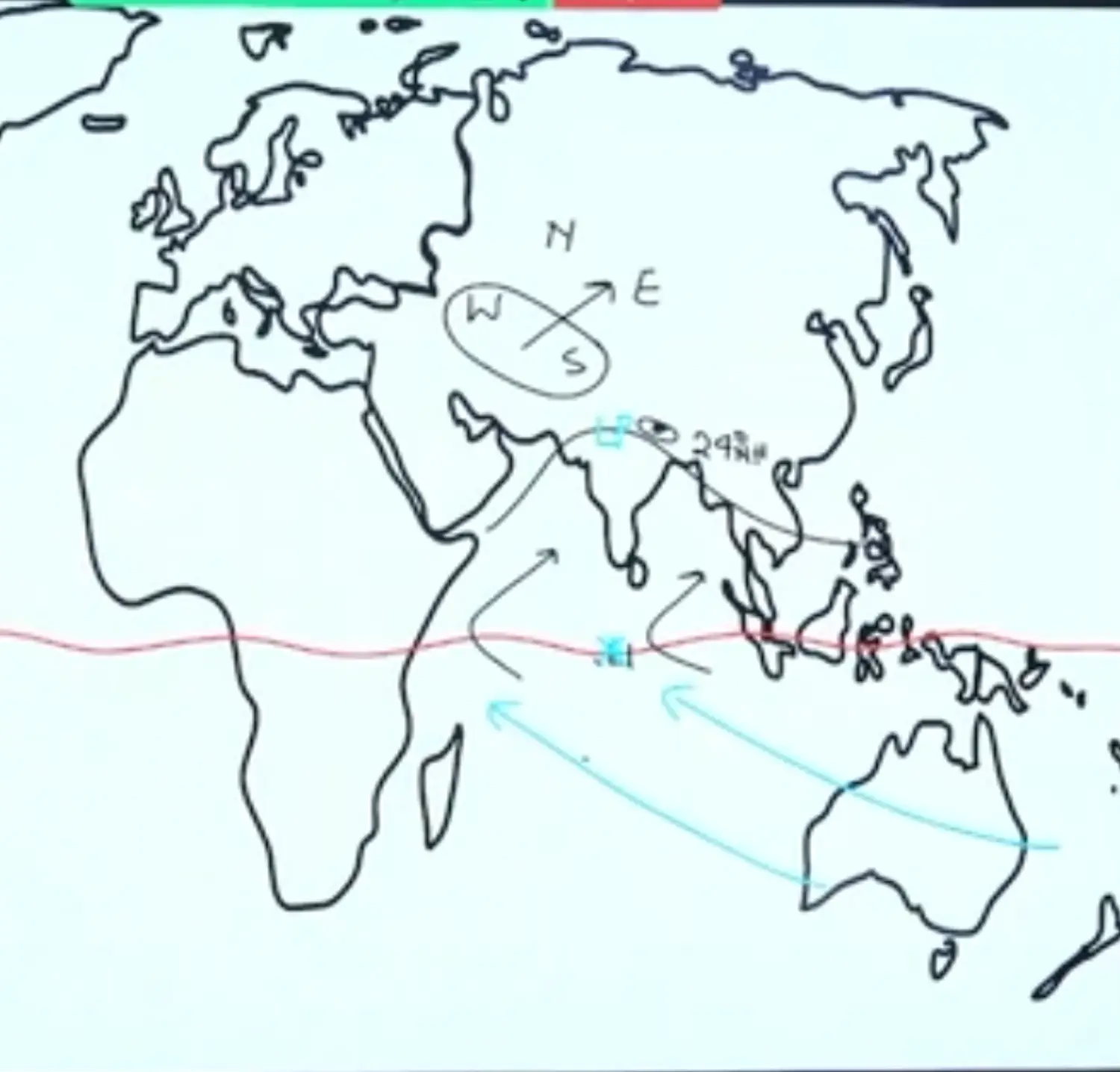
- Cross Equatorial Oceanic Winds (Cross Equatorial South Westerlies) and Continental Winds
Monex Expedition on Monsoon
Joint Experiment of India and USSR ( Present Russia) under Supervision of WMO ( World Meteorological Organisation)
WMO is a Part of Economic and Social Council
From India Professor Koteshwaramma & Other prof was M Yun →
They Propounded that Tibetan Plateau Intensified Indian Monsoon → Cuz they Generate Tropical Easterly Jet Stream which is a Seasonal (Temp) Jet Stream
It is only Formed in Summers due to Heating of Tibetan Plateau → This Jet is also called Koteswaram Jet
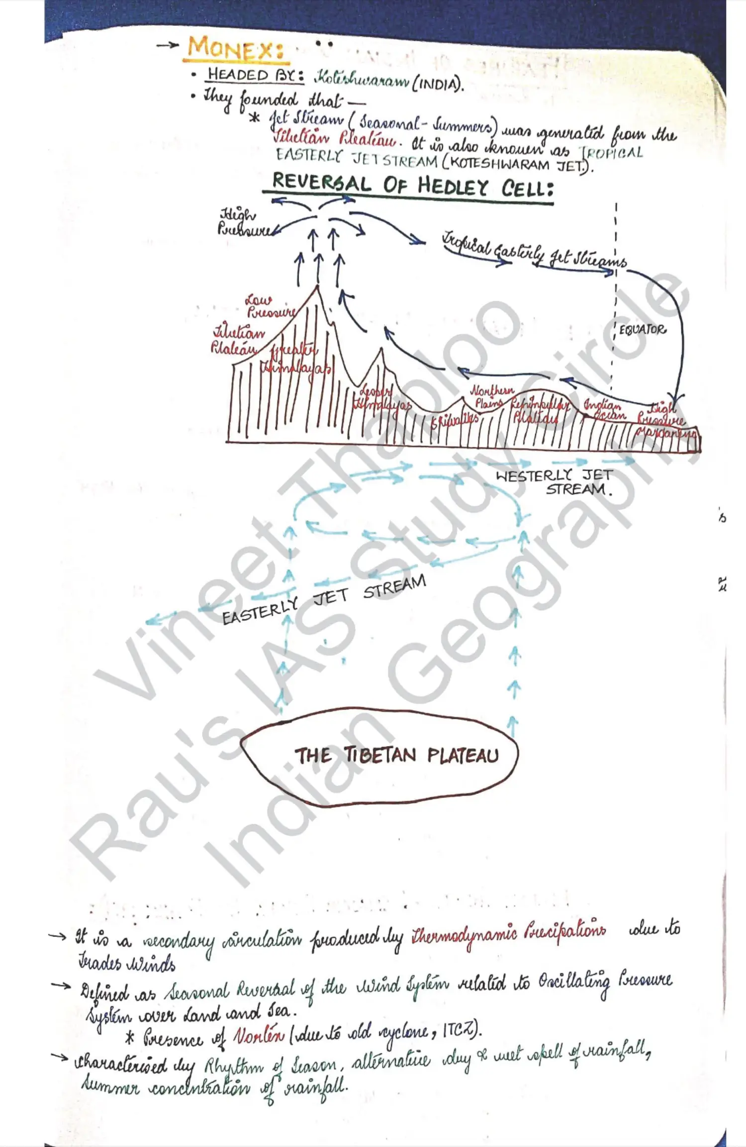
Jet Streams and Tibetan Plateau - Summer Monsoon
Deflection of Subtropical Westerly Jet from Tibetan Plateau to Indian Surface - Running Notes
- Role of Tibetan Plateau is to Intensify Monsoon by Creation of Subtropical Westerly Jet which later becomes Tropical Easterly Jet
- Air Masses are Secondary Circulation embedded within Primary Winds
Diagram 1
Diagram 2 : Cross Sectional Diagram of Meridional or Hadley Cell
Diagram 3
Diagram 4
Role of Tropical Easterly and Tibetan Plateau in Monsoon - Class Dictation
In the Year 1960’s Professor Koteswaram Revolutionised the Monsoon Theory by Introducing
- Role of Tibetan Plateau
- Role of Tropical Easterly Jet
His Theory is Known as Jet Stream Theory, Between 1973 and 78
Monsoon Expedition was Launched by Indo Russian Scientist Group Jointly
The Monext Theory Added Several New Dimensions to the Monsoon Mechanism and our Understanding of Monsoon, Further Grew with the Study of El Nino
Therefore Presently a Synthetic Approach is adopted to Explain Monsoon
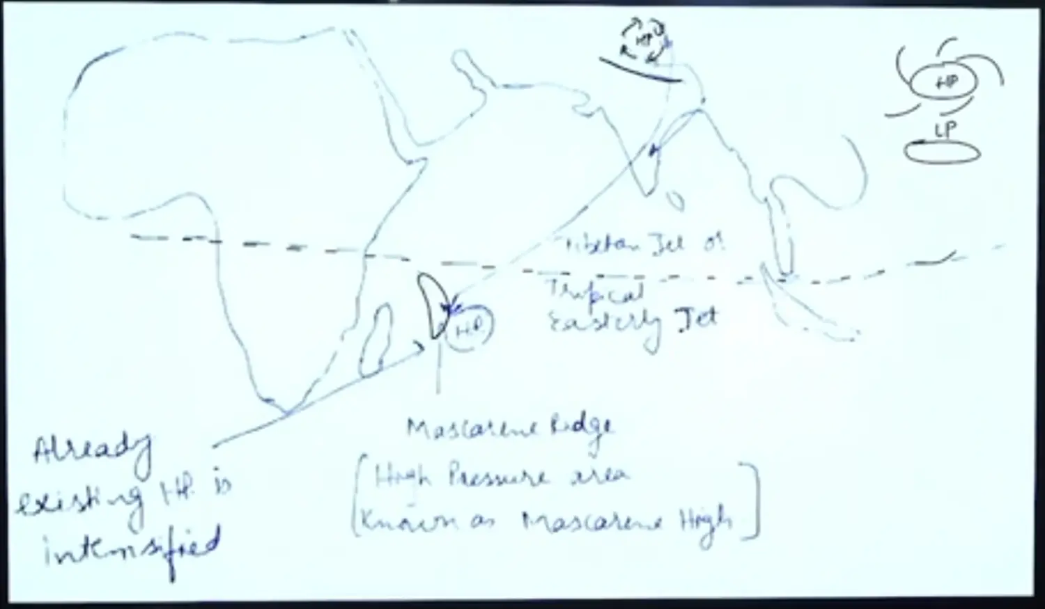
The Heating of Tibetan Plateau because of Its altitude (Avg Height 4 KM) and receives sun rays at lesser distance (More Flux of Insolation)
Tibetan Plateau is Barren with presence of rocks. Rocks have Low Albedo (Absorb More Heat). Hence due to Rocks, It becomes heat sink Zone.
Due to Heating, the Air Tends to Rise upto 12 KM in the Atmosphere, thus resulting in High Pressure and Creation of Anticyclonic Conditions
This Anticyclonic Conditions Results into Divergence or Out Flow of Air
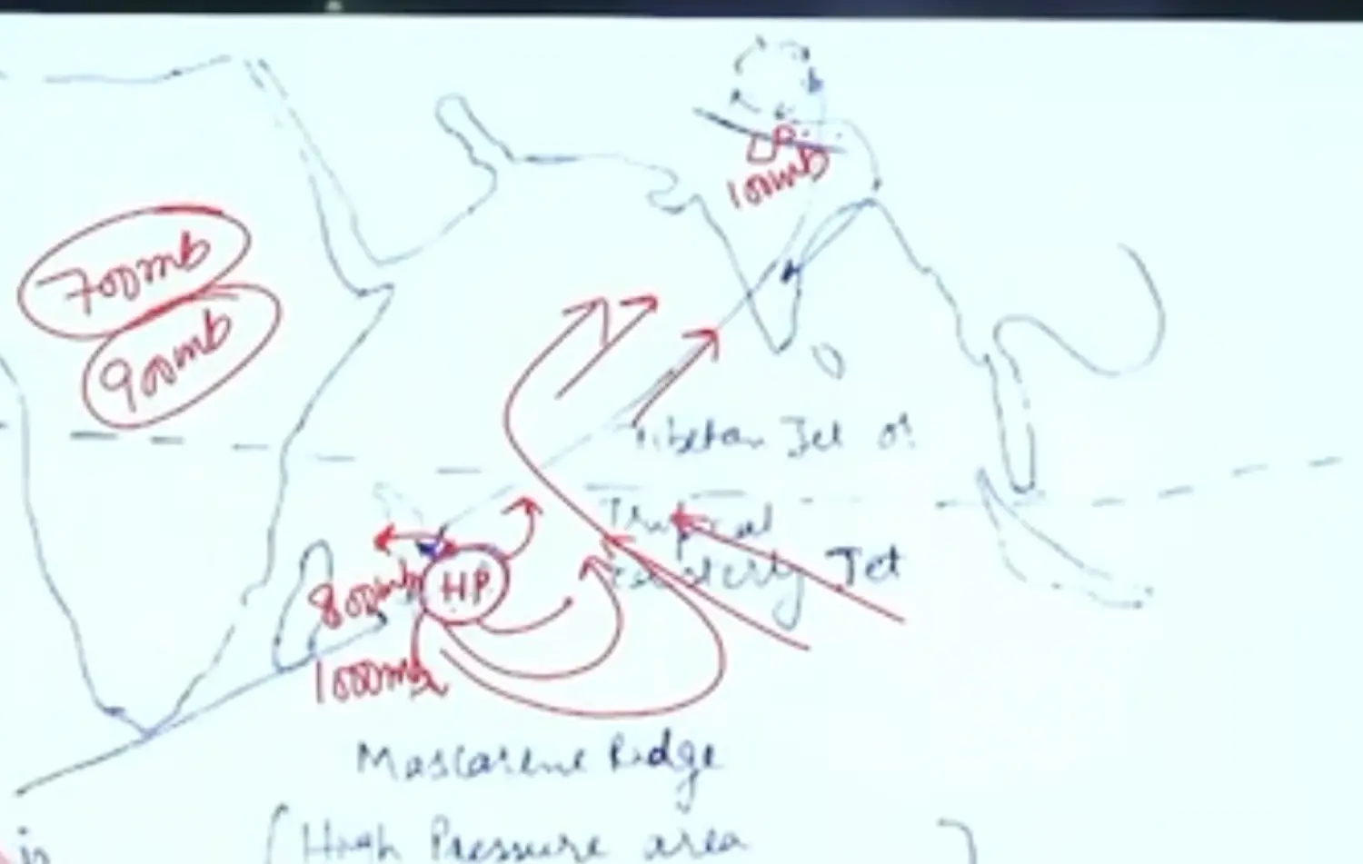
The Subtropical Jet Stream meets with This Anticyclone and Forms of Vortex
And one of the Limb enter the Subtropical Jet and while one of the Limb Drift over North Eastern India and become Tropical Easterly Jet due to Coriolis and Start Crossing Over Karnataka and Begin to Sink over Mascarene Island (East of Madagascar)
It Intensifies Already Intensified HP created over Mascarene Island due to Increased Pressure Gradient between Two Places and Sinking of Jet Stream over HP Area
Bursts of Monsoon
- Introduction
- On First June, Monsoon wind Suddenly invades Malabar Coast where thundering Lightning and Heavy Rain Begins with Cumulonimbus Clouds
- Burst of Monsoon is a Sudden Phenomenon but Advances Gradually
- Prediction of Bursts or Parameters of Bursts
- Appearance of Tropical Easterly Jet
- Existence of Monsoon Trough (Trough is LP)
- Introduction
Winter Monsoon - From PDF (Just Look at the Detail, Mechanism has been Taught)
October Heat
Lot of Humidity → Increased Saturation of Air → No Evapouration → Body Feels Heat
During 23rs of September (Equinox Sun at Equator) to October the Sun Migrates to Southern Hemisphere. The North Indian Plains with Saturated Soil Re Radiates the Absorbed Heats
The Terrestrial Radiation is Maximum, Thus Heat and Moisture Content in Air is too grey producing the Suffocating Environment
Retreat of Monsoon (Retreat and North East Monsoon)
True Retreating Monsoon
- Retreat is Gradual which begins from 2st of september to 30th November. It is caused by the following factors. Southward migration of sun and shifting of ITCZ
- Diminishing Low Pressure System over Tibetan Plateau and Disappearance of Tropical Easterly Jet
- During this time, Himalayas bifurcate the Subtropical Jet into Two Branches. One flows to the south of Himalayas and one North of It
Trough and Ridge of Jet Stream Air - Concept
- Trough - Convergence
- Ridge - Divergence

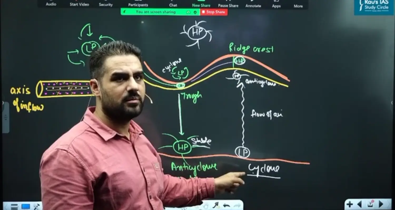
Application of Above Concept to India
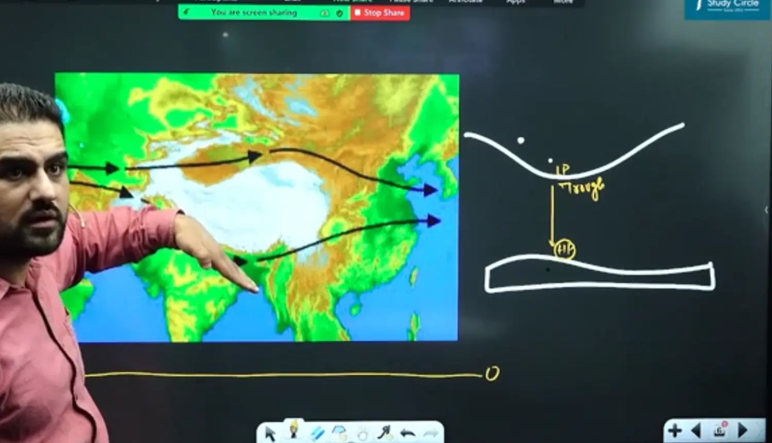
Sub Tropical Trough is Bifurcated by the Height of Himalayas into Two Branches, The Trough of the Jet is Located to the North West of India in Mainly Rajasthan
Thus Below the Trough of the Jet, Anti Cyclonic Flows are Maintained which causes the Retreat.
The Monsoon Retreat, bring 10 to 15 CM Rainfall from Available Moisture in the Soil
Retreat Monsoon and North Eastern Monsoon - Combined
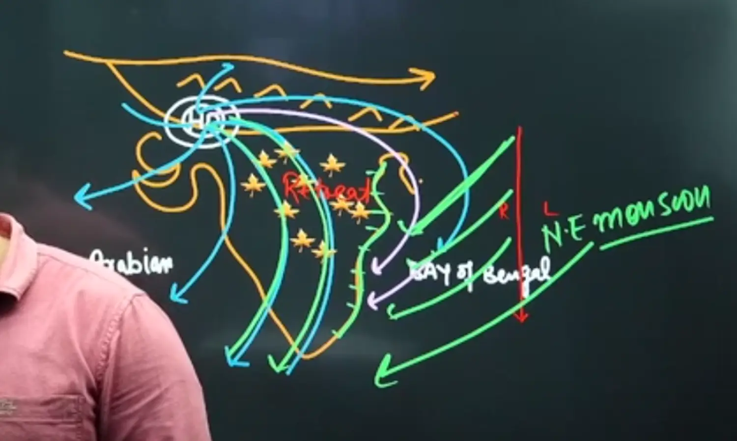
- Retreat Monsoon and North East Monsoon is NOT Same
- Retreat is on Continent
- North East Monsoon is on Ocean or Sea
- Retreat Monsoon and North East Monsoon is NOT Same
North Eastern Monsoon - Extension of Retreating Monsoon
When the Retreat Monsoon Moves Over Bay of Bengal it picks up Sea from Moisture and becomes North Easterlies due to Coriolis Force
North East Monsoon which is a Extension of Retreat Monsoon, This Monsoon is Oblique to the Coromandel Coast which Receives 100 CM Rainfall
At Palani Hills and Nilgiri in South, The Rainfall will be 15 to 20 cm. This continues from 1st December to March ( West Bengals Durga Pooja is Connected to Retreat of Monsoon
Western Disturbance

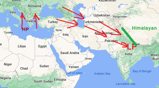
The Saharan Air Mas and European Air Mass (Black Sea, Mediterrenian, Caspian) converge along Mediterranean Sea and Temperate Cyclones are Created
These Temperate Cyclones are Driven to East by Subtropical Westerly Jet as it passes over Black Sea. It Picks up moisture but however remains to the south of Caspian Sea
It Rains 20-30 CM in Afghanistan, because of Low Height of Mountains (Zagreus Mt, Alburus Mt). This Rains is Good for Poppy Cultivation.
These Cyclones entering India are known as Western Disturbances.It Snowfalls in J&K. It Rains Around Punjab, Prayag Raj, Patna and helps in Rabi Cropping.
These Western Disturbances are called Mawat in Western Rajasthan. Over Punjab Himalayas to Assam Himalayas it results into the formation of Glacier and Ice Caps. Here Glaciers will be formed and Perennial Rivers are Highly Enriched
Punjab Himalayas - Between Indus and Sutlej
Between Prayagraj to Patna, Rainfall is received from both Western Disturbances as well as by South West Monsoon
Outline
- Normal Condition - Monsoon Good for India
- La Nina - Intensification of Normal Year Cycle → Indian Monsoon Very Good
- El Nino - Indian Monsoon will be very Weak
- Modoki
- El Nino Modoki - Indian Monsoon Weak
- La Nina Modoki - Indian Monsoon Good
- Southern Oscillation (SO)
- EN SO - Low → Indian Monsoon Weak
- La Nina SO - Low → Indian Monsoon Good
- Walker Cell
- Reverse
- Weakening - Weakening of Indian Monsoon
- Indian Ocean Dipole (Indian Nina)
- Positive Indian Ocean Dipole
- Negative Indian Ocean Dipole
El Nino & La Nina ( Allied Walker Cell Reversal)
Important Point to Note
- Wind Moves from High to Low
- Warm Place - Water or Air - High Pressure
- Cold Place - Water or Air - Low Pressure
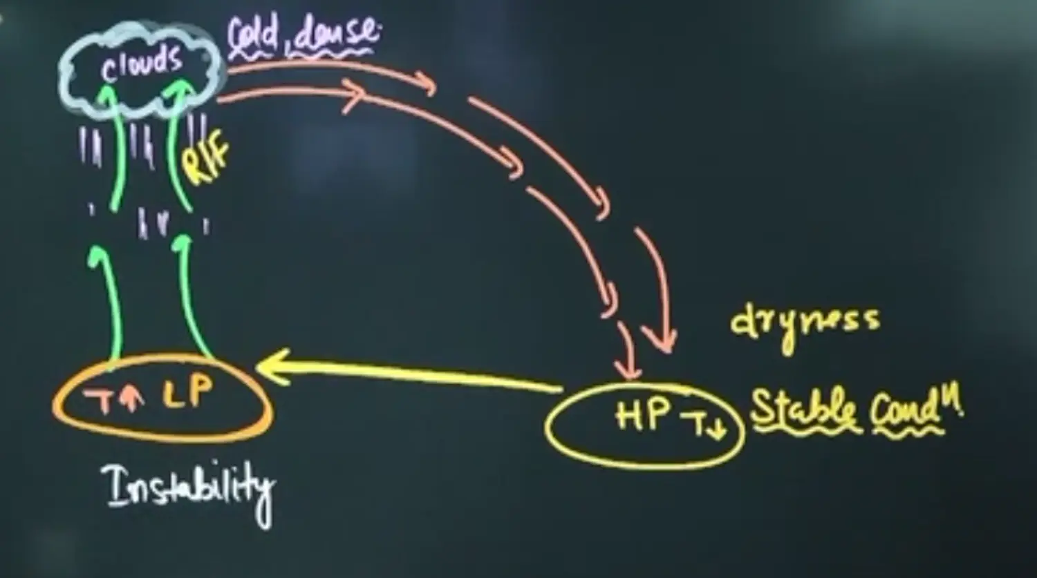
- Sinking Air does not give Rainfall as it Suppresses Clouds → Leading to Dryness and Sometimes Forest Fires in Australia
- Wind Diverges from High Pressure
- The Air Which Rises becomes Cold
| Warm Water | Cold Water | | --- | --- | | Downwelling | Upwelling | | On Shore | Off Shore | | Not Good For Fishing | Good for Fishing | | Seal Level Increase | Seal Level Decrease | | Deeper Thermocline | Shallow Thermoclines | | Low Pressure | High Pressure | | Rising Air - Instability | Sinking Air - Stability |
Normal Concept 👇
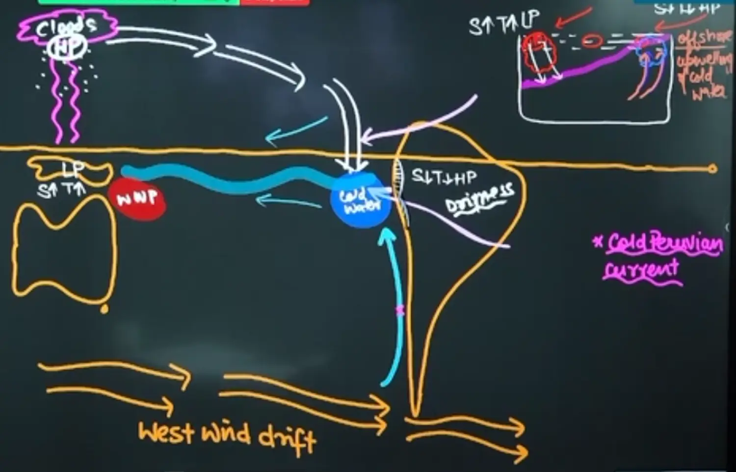
Application of Concept 👇 → in Pacific Ocean
Extension of this to India & Indian Ocean 👇
Mascarene Island is a High Pressure Zone. Hence is called Mascarene High → Hence this is the Story of Normal Year
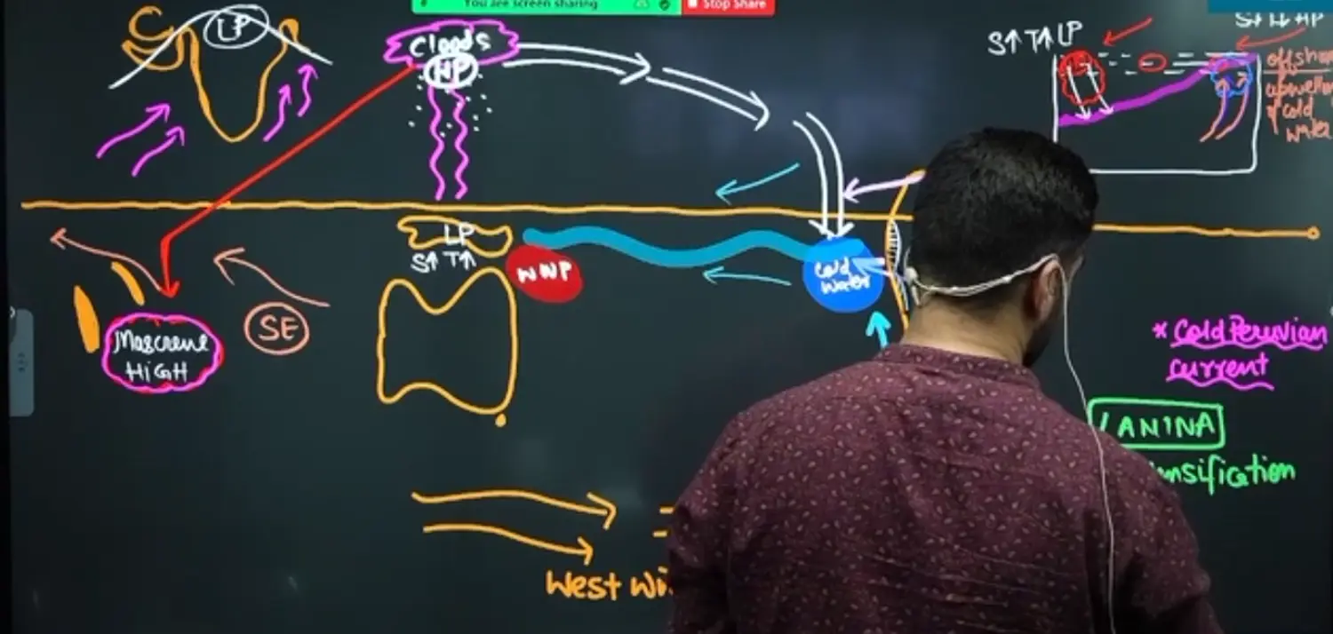
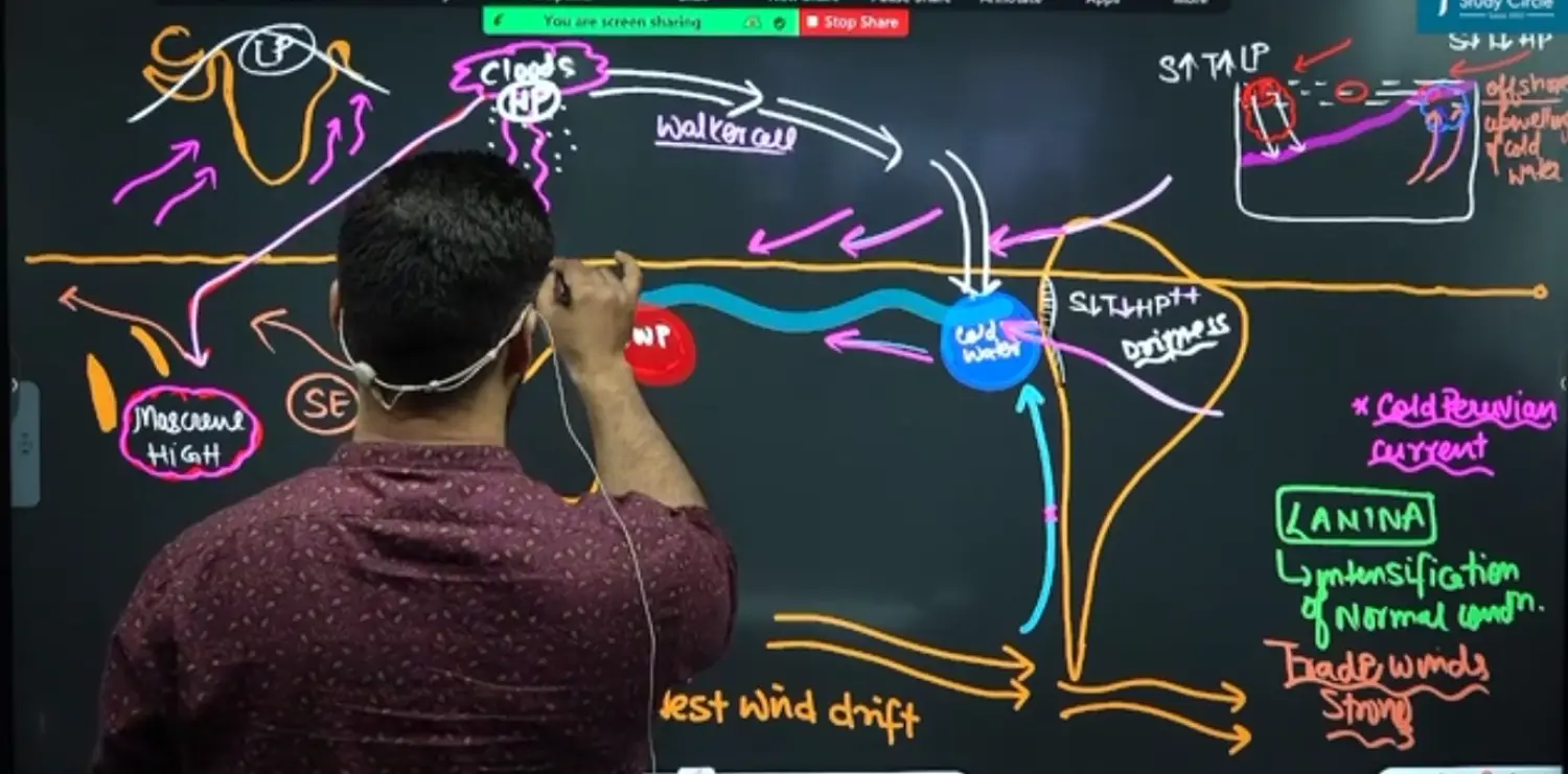
Intensification of Normal Conditions - La Nina (Baby Girl) 👇
Here North East Trade Winds above Equator Intensify the Conditions - Which Results in Further Intensification of the Whole System
Here there is Normal Condition Walker Cell
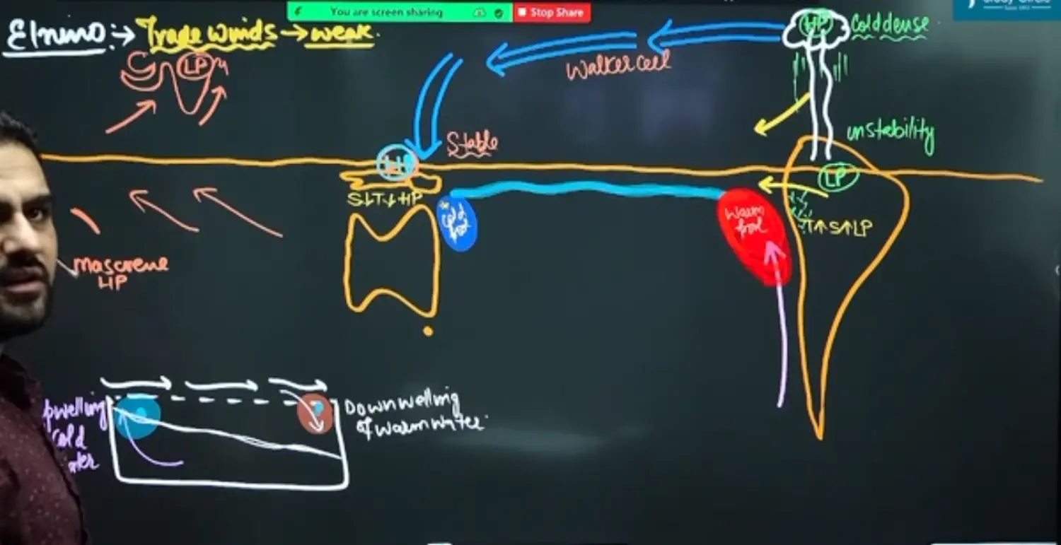
Weakening of Normal Conditions - El Nino (Baby Boy) 👇
Here North East Trade Winds Become Weak → Due to increased Ocean Temperature → May Be Due to
- Nuclear Test in Funafuti Island making Ocean Water Warm
- Due to Sun Spots, Solar Storms etc
- Due to Aphelion and Perihelion
El Nino is the Replacement of Cold Peruvian Current with Warm Water → please Remember it is NOT the Cross Equatorial Current.
It is the extension and spread of Warm Water Pool at the Eastern Coast of South America
Here there is Reversal of Walker Cell
Generally El Nino is associated with Bad Monsoon but sometimes due to Intense Heating of Tibetan Plateau and allied Intensification of Tropical Easterly Jet ; Despite Occurrence of El Nino, There might be Good Rainfall in India
The Case of “Modoki”
La Nina Modoki - It Doesn't Affect Indian Monsoon
The Cold Pool of Water Slightly Shifts in the Following Manner 👇
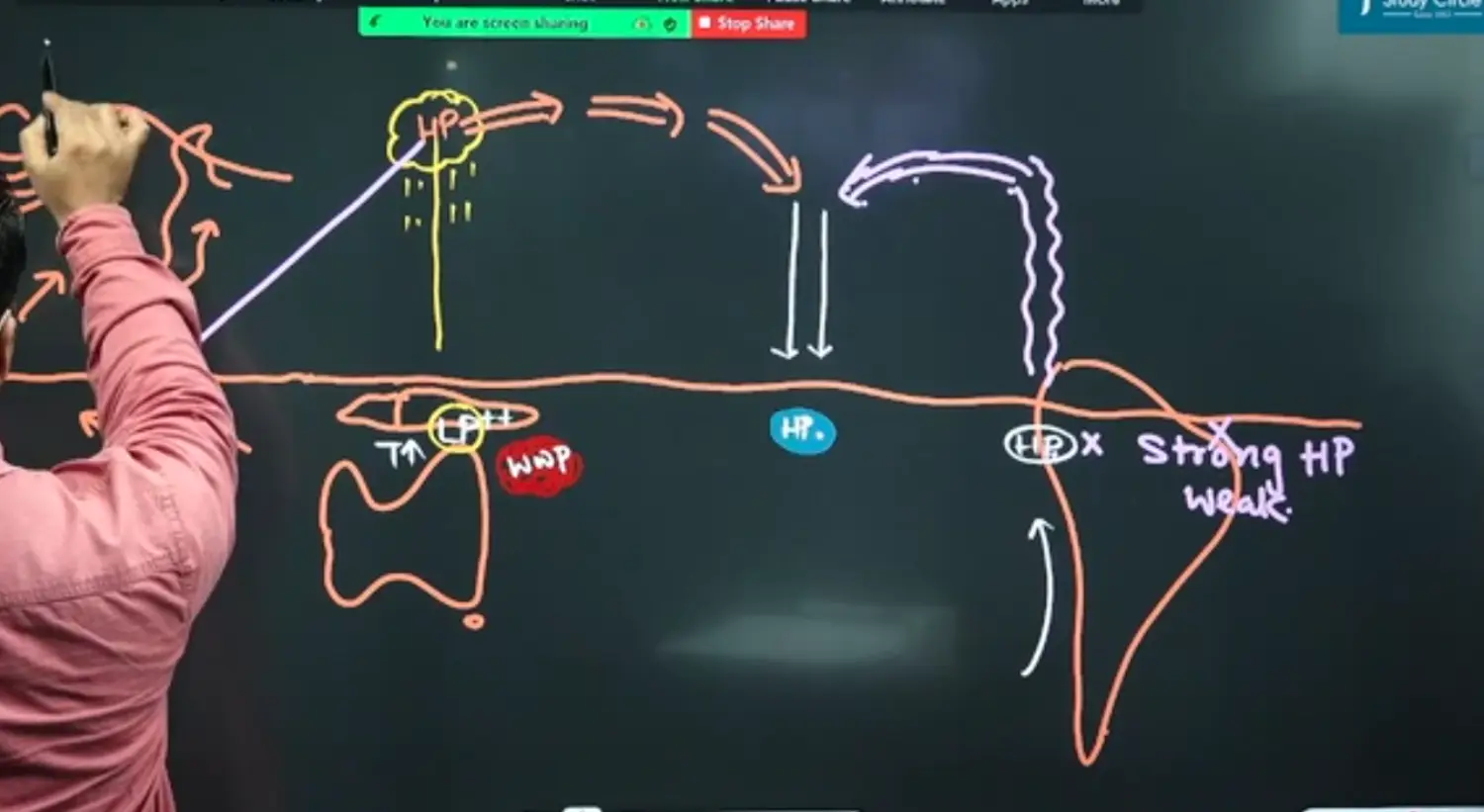
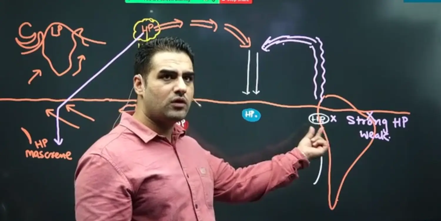
El Nino Modoki - Bad for Indian Monsoon
This is real El Nino Condition 👇
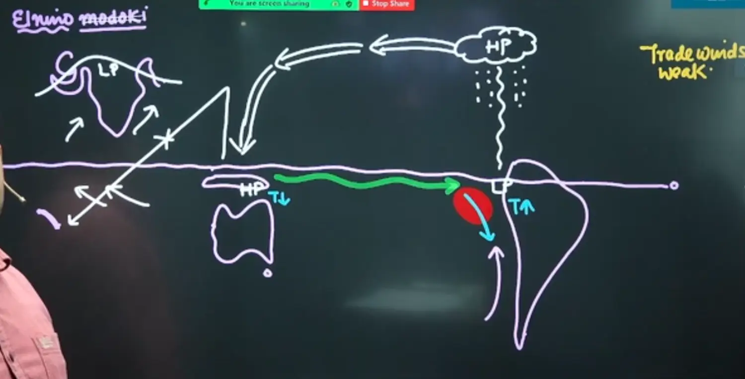
Now El Nino Modoki Is 👇👇👇
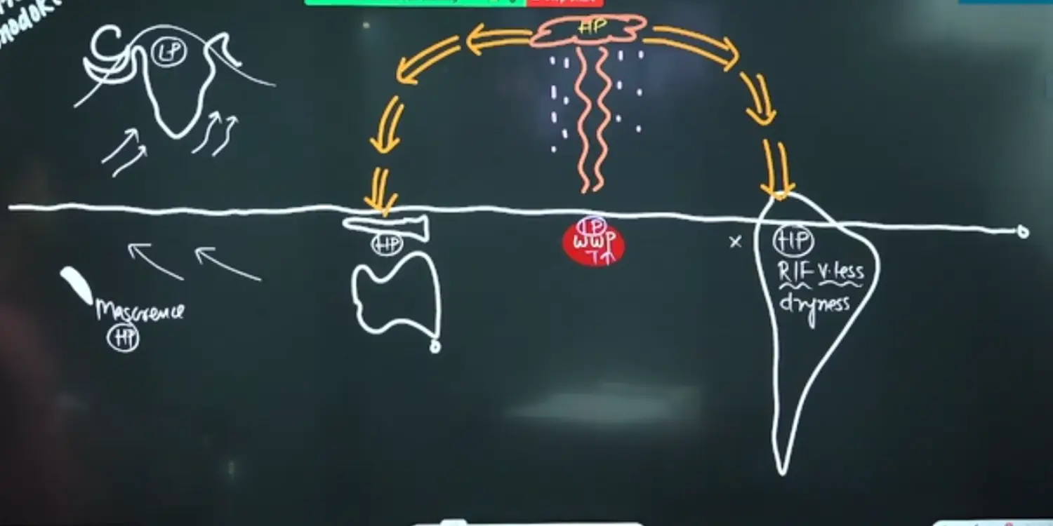
Due to Absence of Rising Air from Australia - Pressure Gradient becomes Weak
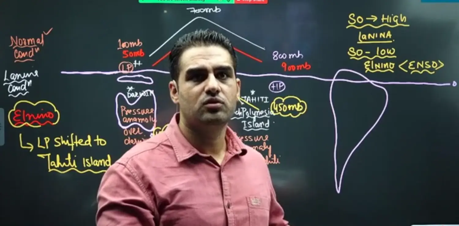
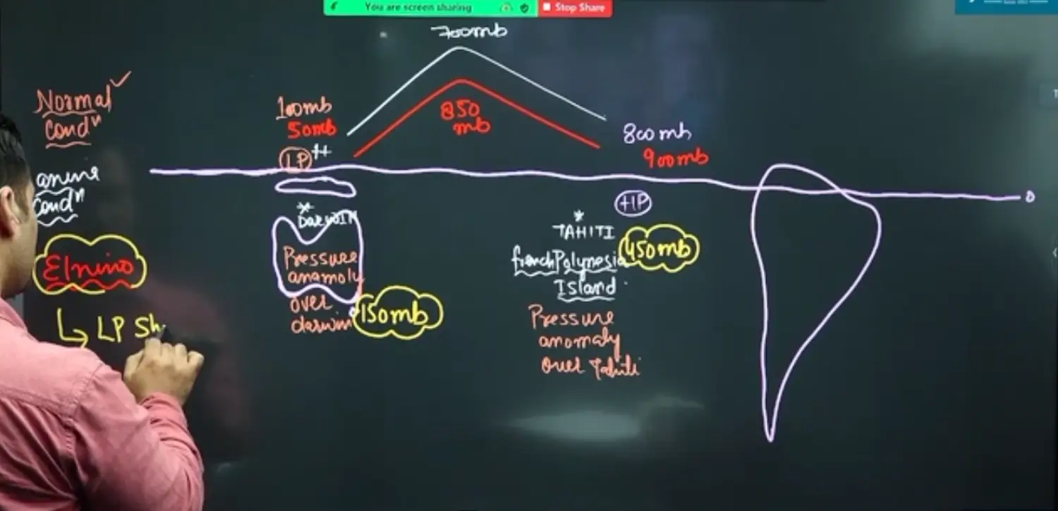
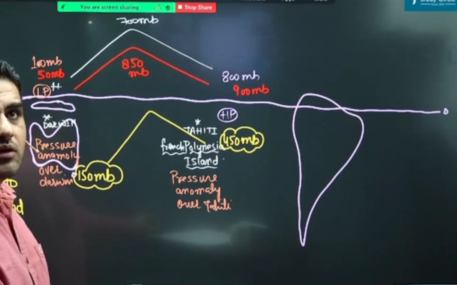
Southern Oscillation
It is Pressure Difference Between Two Points or Two Places
- Place 1 - Port of Darwin, Australian
- Place 2 - Tahiti, Central Pacific
The Three Conditions Are
- Normal Condition
- La Nina Condition - La Nina SO - LaSO → Here Southern Oscillation is High / Intensification → Good for Indian Monsoon
- El Nino Condition - EL Nino SO - EnSO → Here Southern Oscillation is Low / Weakening → Not Good for Indian Monsoon
Explanatory Image
Indian Ocean Dipole (IOD)
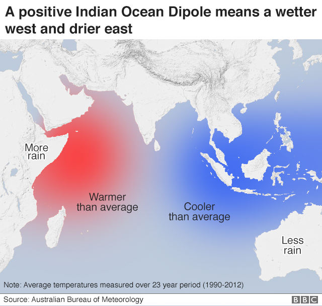
It is called Dipole because two places are into consideration
IOD is also called India NINA as well. It means EL Nino like phenonmenon in Indian Ocean
IOD is a Local Phenonmenon confined to Indian Ocean
It can happen at any time but if it happens during Monsoon then its a issue based on positive or negative
Earlier it was occuring in every 5 to 7 years but now the phenomenon is frequent and hence we can say that the sea surface temperature is increasing
One of the reasons being given is the Nuclear Tests done by USA in Funafuti Island of Marhsall Islands under USA
Another Reason given there is Solar Cycle (Phase of 7 to 13 Years) and Sun Spot Activities. But now Solar Cycle Phenomenon has become a more freuqent Option
Another Reason given is that of Aphelion and Perihilion, but the reasons does not seem to be that strong as this is also dependent on the Clarity of Sky
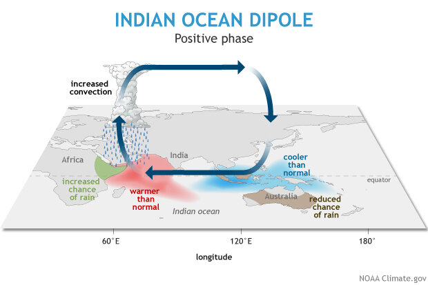
Positive IOD → Good Monsoon
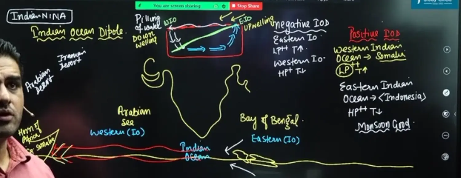
Western Indian Ocean → Somalia → Low Pressure → Temp High → Downwelling Warm Water
Eastern Indian Ocean → Indonesia → High Pressure → Temp Low → Upwelling of Cold Water
Thermocline will be created
Monsoon will be good for India because South East Trade Winds of Arabian Sea Branch will carry moisture from the IOD Movemenets of Winds Sinking in Bay of Bengal
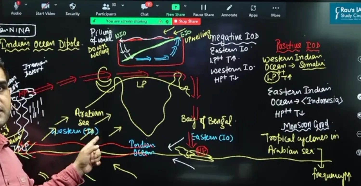
Frequency of Tropical Cyclone in Arabian Sea will Increase
Frequency of Tropial Cyclone in Bay of Bengal will Decrease
For Tropical Cyclone, we need 27 degree celsius temperature and warm water at the depth of atleast 60 Meter
IOD nullifies effect of El Nino
Australlia, Borneo Island will experience Forest Fires because of HP created by sinking of Dry Air of Positive IOD and El Nino
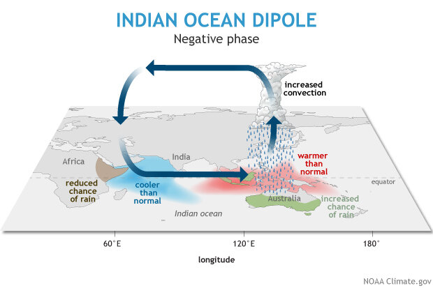
Negative IOD → Bad Monsoon
- Western Indian Ocean → Somalia → High Pressure → Temp Low
- Eastern Indian Ocean → Indonesia → Low Pressure → Temp High
- Monsoon will be bad for India